1.3K
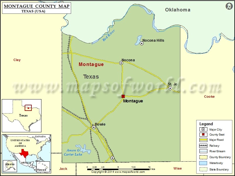
Check this Texas County Map to locate all the state’s counties in Texas Map.
Mountain Peaks in Montague County
| Mountain Peak/Hill | Elevation [Meter] |
|---|---|
| Benton Hill | 324 |
| Blue Mound | 395 |
| Blue Mound | 312 |
| Brushy Mound | 363 |
| Buzzard Roost Knob | 345 |
| Colt Mountain | 295 |
| Cougar Mountain | 348 |
| Dead Ox Mound | 320 |
| Double Mounds | 288 |
| Dye Mound | 388 |
| Flag Mound | 283 |
| Gordon Mountain | 393 |
| Grindstone Mountain | 339 |
| Jack Mound | 348 |
| Jim Ned Lookout | 394 |
| McCracken Mound | 343 |
| Mount View | 393 |
| Newby Mound | 368 |
| Norton Mountain | 336 |
| Queens Peak | 352 |
| Rattlesnake Mountain | 339 |
| Red Mound | 296 |
| Snake Hill | 299 |
| Sugarloaf Mound | 356 |
| Tadlock Hill | 362 |
Airports in Montague County
| Airport Name |
|---|
| Bowie Municipal Airport |
| Flying F Airport |
| Nocona Airport |
| Sky Acres Airport |
| Western Sky Airport |
Cities in Montague County
| City | Population | Latitude | Longitude |
|---|---|---|---|
| Bowie city | 5218 | 33.556668 | -97.84401 |
| Montague | 304 | 33.665271 | -97.720954 |
| Nocona city | 3033 | 33.783556 | -97.73017 |
| Nocona Hills | 675 | 33.852403 | -97.643506 |
| St. Jo city | 1043 | 33.695023 | -97.523071 |
| Sunset | 497 | 33.44795 | -97.766354 |
Golf Courses in Montague County
| Name of Golf Course | Latitude | Longitude |
|---|---|---|
| Bowie Golf Club-Bowie | 33.476711 | -97.86807 |
| Indian Oaks Golf Club-Nocona | 33.783879 | -97.735072 |
| Nocona Hills Golf Course-Nocona | 33.835808 | -97.630899 |
| Prairie Oaks Ranch-Bowie | 33.549757 | -97.846921 |
 Wall Maps