2.5K
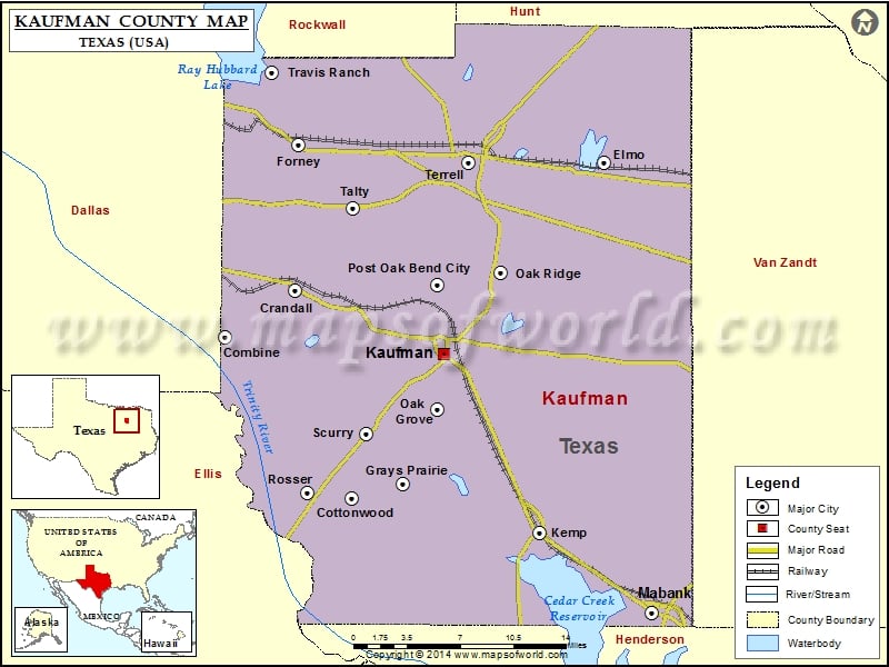
Check this Texas County Map to locate all the state’s counties in Texas Map.
Mountain Peaks in Kaufman County
| Mountain Peak/Hill | Elevation [Meter] |
|---|---|
| Breezy Hill | 165 |
| Sand Hill | 117 |
Airports in Kaufman County
| Airport Name |
|---|
| Airpark East Airport |
| Baum Airport |
| Bennetts Airport |
| Charlton Methodist Hospital Heliport |
| Connies Aviation Airport |
| Erco Field |
| Hall Airport |
| Moore Airport |
| Smith Field |
| Sunset Airport |
| Terrell Community Hospital Heliport |
| Terrell Municipal Airport |
| Twin Acres Airport |
| Wings Over Texas Airport |
Cities in Kaufman County
| City | Population | Latitude | Longitude |
|---|---|---|---|
| Combine city | 1942 | 32.591012 | -96.520249 |
| Cottonwood city | 185 | 32.460877 | -96.39986 |
| Crandall city | 2858 | 32.628083 | -96.453419 |
| Elmo | 768 | 32.731481 | -96.158998 |
| Forney city | 14661 | 32.747149 | -96.452089 |
| Grays Prairie village | 337 | 32.472634 | -96.350725 |
| Kaufman city | 6703 | 32.577515 | -96.312084 |
| Kemp city | 1154 | 32.432421 | -96.22058 |
| Mabank town | 3035 | 32.368225 | -96.114015 |
| Oak Grove town | 603 | 32.532109 | -96.318188 |
| Oak Ridge town | 495 | 32.64289 | -96.257315 |
| Post Oak Bend City town | 595 | 32.632568 | -96.318027 |
| Rosser village | 332 | 32.464998 | -96.442159 |
| Scurry town | 681 | 32.512822 | -96.385437 |
| Talty town | 1535 | 32.69451 | -96.398439 |
| Terrell city | 15816 | 32.730797 | -96.287807 |
| Travis Ranch | 2556 | 32.802546 | -96.475883 |
Golf Courses in Kaufman County
| Name of Golf Course | Latitude | Longitude |
|---|---|---|
| Cedar Creek Country Club-Kemp | 32.378518 | -96.166386 |
| Creekview Golf Club-Crandall | 32.62872 | -96.449629 |
| Indian Oaks Golf Club-Kemp | 32.394115 | -96.368555 |
| King’s Creek Golf Club-Kemp | 32.407805 | -96.249675 |
| Oak Grove Golf Course-Terrell | 32.752959 | -96.30128 |
| Pecan Ridge Golf Club-Scurry | 32.520971 | -96.441832 |
 Wall Maps