1.8K
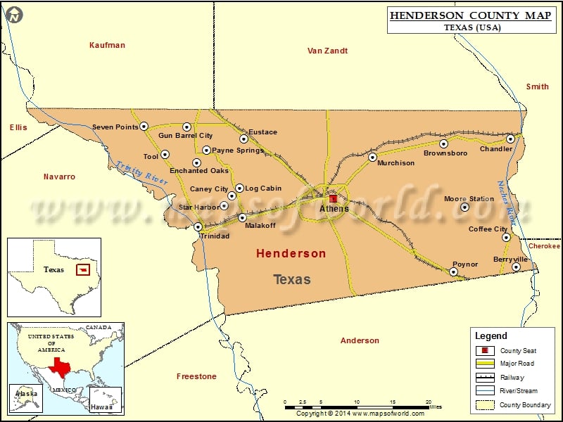
Check this Texas County Map to locate all the state’s counties in Texas Map.
Mountain Peaks in Henderson County
| Mountain Peak/Hill | Elevation [Meter] |
|---|---|
| Cooper Mountain | 192 |
| Jennings Mountain | 212 |
| Melton Rock | 196 |
| Pine Grove Hill | 151 |
| Rock Hill | 214 |
| Tater Hill Mountain | 234 |
More Maps of Henderson County
Airports in Henderson County
| Airport Name |
|---|
| Aero Estates Airport |
| Athens Municipal Airport |
| Circle R Ranch Airport |
| Coon Creek Club Heliport |
| Echo Lake Airport |
| Etmc – Athens Heliport |
| Etmc – Gun Barrel City Heliport |
| Harbor Point Airport |
| Medical Emergency Gbc Heliport |
| Paradise Point Airport |
| Pickle Plantation Airport |
Cities in Henderson County
| City | Population | Latitude | Longitude |
|---|---|---|---|
| Athens city | 12710 | 32.205209 | -95.834857 |
| Berryville town | 975 | 32.087768 | -95.466668 |
| Brownsboro city | 1039 | 32.29842 | -95.613042 |
| Caney City town | 217 | 32.209618 | -96.038146 |
| Chandler city | 2734 | 32.306486 | -95.478115 |
| Coffee City town | 278 | 32.138291 | -95.487094 |
| Enchanted Oaks town | 326 | 32.266601 | -96.108989 |
| Eustace city | 991 | 32.307544 | -96.013802 |
| Gun Barrel City city | 5672 | 32.327678 | -96.128817 |
| Log Cabin city | 714 | 32.223082 | -96.022261 |
| Malakoff city | 2324 | 32.17276 | -96.016246 |
| Moore Station city | 201 | 32.190556 | -95.570392 |
| Murchison city | 594 | 32.275171 | -95.756069 |
| Payne Springs town | 767 | 32.286257 | -96.0909 |
| Poynor town | 305 | 32.079342 | -95.592372 |
| Seven Points city | 1455 | 32.329026 | -96.214248 |
| Star Harbor city | 444 | 32.192781 | -96.054197 |
| Tool city | 2240 | 32.280348 | -96.172532 |
| Trinidad city | 886 | 32.156204 | -96.105355 |
Golf Courses in Henderson County
| Name of Golf Course | Latitude | Longitude |
|---|---|---|
| Athens Country Club-Athens | 32.193359 | -95.861656 |
| Echo Creek Country Club-Murchison | 32.24048 | -95.660715 |
| Pinnacle Country Club-Mabank | 32.221251 | -96.074849 |
| Star Harbor Golf Club-Malakoff | 32.194514 | -96.054011 |
 Wall Maps