2.4K
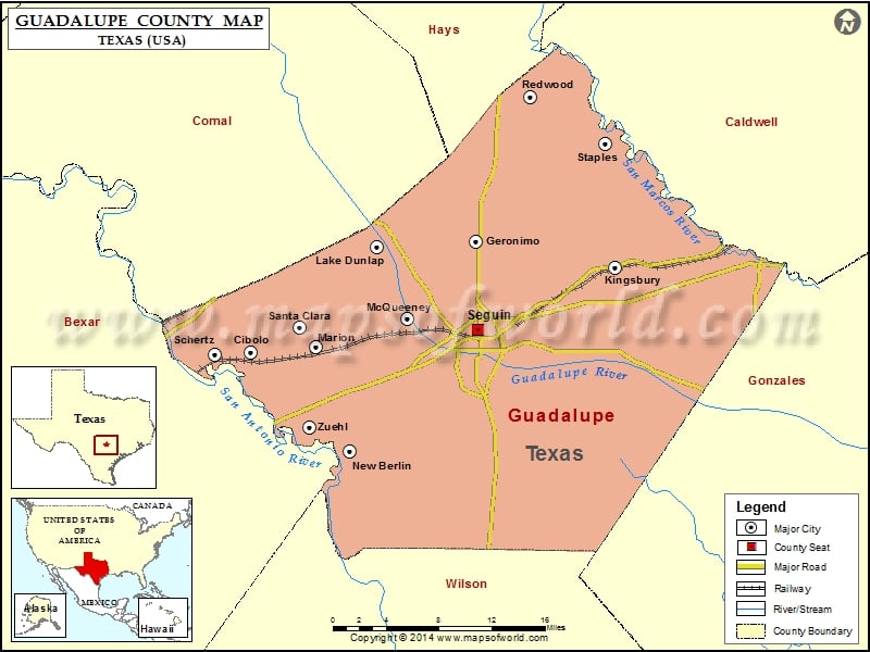
Check this Texas County Map to locate all the state’s counties in Texas Map.
Mountain Peaks in Guadalupe County
| Mountain Peak/Hill | Elevation [Meter] |
|---|---|
| Capote Hills | 181 |
| Capote Knob | 209 |
| Harborth Hill | 214 |
| Kings Hill | 228 |
| Mill Creek Hills | 214 |
Airports in Guadalupe County
| Airport Name |
|---|
| Alison Air Park |
| Cibolo Sea-Willo Airpark |
| Cunningham Airpark |
| Elm Creek Airpark |
| Gary’s Airport |
| Glen Beicker Ranch Airport |
| Guadalupe Hospital Heliport |
| H M Ranch Airport |
| Heritage Airfield |
| Hilltop Ranch Airport |
| Huber Airpark Civic Club Llc Airport |
| Joe Fleming Field |
| Lackorn Airport |
| Moltz Airport |
| New Braunfels Municipal Airport |
| Old Kingsbury Aerodrome |
| Randolph Air Force Base Auxiliary Airport |
| Saint’s Strip Ultralightport |
| Woodstone Corporation Heliport |
| Zuehl Airport |
Cities in Guadalupe County
| City | Population | Latitude | Longitude |
|---|---|---|---|
| Cibolo city | 15349 | 29.577312 | -98.23569 |
| Geronimo | 1032 | 29.672801 | -97.968569 |
| Kingsbury | 782 | 29.648381 | -97.817697 |
| Lake Dunlap | 1934 | 29.668048 | -98.077577 |
| Marion city | 1066 | 29.572568 | -98.142941 |
| McQueeney | 2545 | 29.599433 | -98.04379 |
| New Berlin city | 511 | 29.47216 | -98.106595 |
| Redwood | 4338 | 29.810025 | -97.910301 |
| Santa Clara city | 725 | 29.592058 | -98.160795 |
| Schertz city | 31465 | 29.567607 | -98.257402 |
| Seguin city | 25175 | 29.588812 | -97.966272 |
| Staples city | 267 | 29.766346 | -97.827857 |
| Zuehl | 376 | 29.496406 | -98.151105 |
Golf Courses in Guadalupe County
| Name of Golf Course | Latitude | Longitude |
|---|---|---|
| Birdee’s Golf Center & Driving Range-New Braunfels | 29.640719 | -98.122601 |
| Golf Club of Sequin-Sequin | 29.548708 | -97.981458 |
| Max Starcke Park Golf Club-Sequin | 29.556182 | -97.964119 |
| Northcliffe Country Club-Cibolo | 29.624539 | -98.227162 |
| The Bandit Golf Club-New Braunfels | 29.625497 | -98.064913 |
 Wall Maps