- Ohio Counties - Ohio County Map, Map of Ohio Counties
- Major Cities of Ohio - Toledo, Columbus
- Neighbouring States - Michigan, Pennsylvania, West Virginia, Kentucky, Indiana
- Regional Maps - Map of USA
- Other Ohio Maps - Ohio Map, Where is Ohio, Ohio Physical Map, Ohio Lat Long Map, Ohio Zip Code Map, Ohio Area Code Map, Ohio National Parks Map
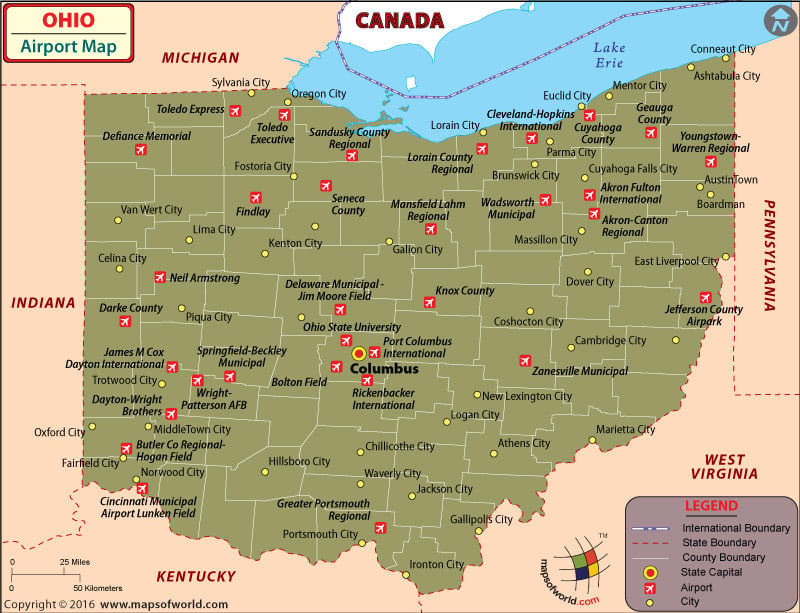
There are 124 General aviation airports in Ohio. The airports in Ohio are well-equipped to handle the abundant traffic that flows into the state annually. Airports in the state are customer-friendly and provide superior services.
Airports in Ohio
The international airports in Ohio include the following:
The Cleveland-Hopkins International Airport in Cleveland, Port Columbus International Airport at Columbus and James M. Cox International Airport at Dayton.
Apart from these, there are also international general aviation airports in Ohio. These include:
Akron-Canton Airport at North Canton and the Rickenbacker International Airport at Columbus.
The Cleveland-Hopkins International Airport is the largest and busiest airport in Ohio. The airport has many shops and restaurants, ATM Machines, a chapel, a foreign currency exchange, business/convention centers, and lounges. The airport also has facilities for people with disabilities which include TTY phones, wheelchair assistance, wheelchair accessible restrooms, accessible elevators and easy disabled parking. There are friendly airport ambassadors who are available to assist people when required. Some airlines serving this airport include:
- Delta Airlines
- American Airlines
- Air Canada
- Southwest Airlines
The Port Columbus International Airport is another prominent airport in Ohio. It offers many amenities and services such as a meditation room, skycap service, massage chairs, a shoeshine shop, a business center equipped with all technological support systems and free wireless internet services. It also has TDD phones, standardized signage and easy parking, for people with disabilities.
The airlines that serve this airport are:
- Air Canada
- United Express
- Southwest Airlines
- American Airlines
- Delta Connection
One can frequently purchase tickets for these airlines at a discount when booking tickets online.
The major airports in Ohio are at Lorain, Cleveland, Toledo, Sandusky, Warren, Akron, Wooster, New Philadelphia, Cambridge, Mansfield, Marion, Findlay, Van Wert, Defiance, Lima, Columbus, Zanesville, Lancaster, Athens, Dayton, Middletown, Hamilton, Cincinnati, Hillsboro, Portsmouth, and Gallipolis.
Maps of Major Airports in Ohio
- Cleveland Hopkins International Airport Map
- Port Columbus International Airport Map
- Rickenbacker International Airport Map
List of Airports in Ohio
| Airport Name | Code | City | Hub | Enplanements (2015) |
|---|---|---|---|---|
| Cleveland-Hopkins International | CLE | Cleveland | M | 3,916,922 |
| Port Columbus International | CMH | Columbus | M | 3,312,496 |
| James M Cox Dayton International | DAY | Dayton | S | 1,041,759 |
| Akron-Canton Regional | CAK | Akron | S | 759,335 |
| Toledo Express | TOL | Toledo | N | 94,044 |
| Rickenbacker International | LCK | Columbus | N | 83,466 |
| Youngstown-Warren Regional | YNG | Youngstown | N | 66,299 |
| Cincinnati Municipal Airport Lunken Field | LUK | Cincinnati | N | 17,354 |
| Cuyahoga County | CGF | Cleveland | None | 230 |
| Mansfield Lahm Regional | MFD | Mansfield | None | 124 |
| Wright-Patterson AFB | FFO | Dayton | None | 65 |
| Butler Co Regional-Hogan Field | HAO | Hamilton | None | 62 |
| Toledo Executive | TDZ | Walbridge | None | 48 |
| Delaware Municipal – Jim Moore Field | DLZ | Delaware | None | 29 |
| Akron Fulton International | AKR | Akron | None | 18 |
| Zanesville Municipal | ZZV | Zanesville | None | 11 |
| Lorain County Regional | LPR | Lorain | None | 8 |
| Marion Municipal | MNN | Marion | None | 8 |
| Ohio State University | OSU | Columbus | None | 8 |
| Bolton Field | TZR | Columbus | None | 7 |
| Dayton-Wright Brothers | MGY | Dayton | None | 6 |
| Defiance Memorial | DFI | Defiance | None | 5 |
| Findlay | FDY | Findlay | None | 5 |
| Wadsworth Municipal | 3G3 | Wadsworth | None | 4 |
| Greater Portsmouth Regional | PMH | Portsmouth | None | 4 |
| Springfield-Beckley Municipal | SGH | Springfield | None | 4 |
| Jefferson County Airpark | 2G2 | Steubenville | None | 3 |
| Darke County | VES | Versailles | None | 3 |
| Seneca County | 16G | Tiffin | None | 2 |
| Knox County | 4I3 | Mount Vernon | None | 1 |
| Geauga County | 7G8 | Middlefield | None | 1 |
| Neil Armstrong | AXV | Wapakoneta | None | 1 |
| Sandusky County Regional | S24 | Fremont | None | 1 |
 Wall Maps