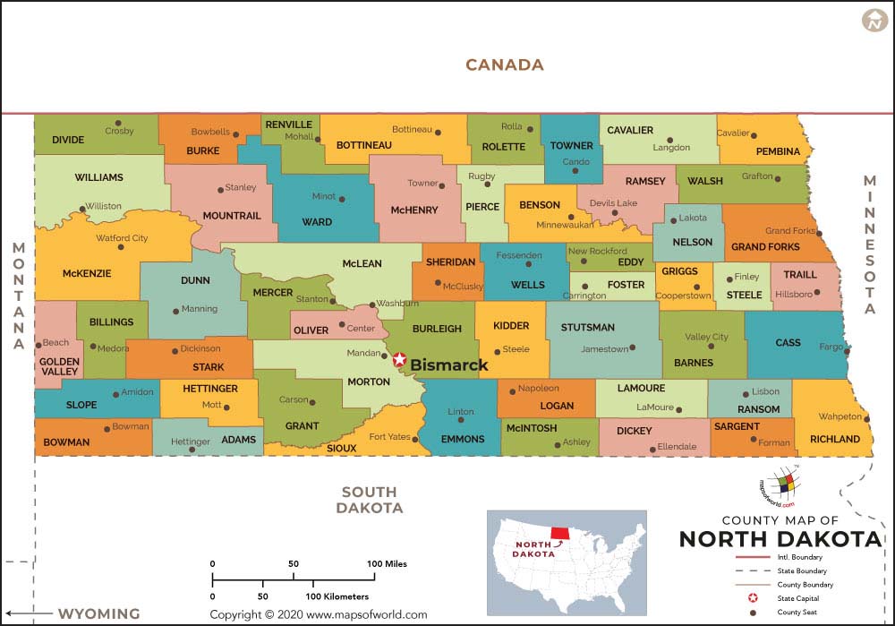
North Dakota County map shows all the various counties that make up the state and also gives a clear indication of their relative geographical positions.
Besides, the map also shows the neighboring states like Montana, Minnesota and South Dakota
Adams County
The estimated population of Adams County is 2,343. It has been named after John Quincy Adams who served as a railroad officer for Milwaukee Road Railroad and was a distant relative of erstwhile US President John Quincy Adams. Hettinger is the seat of this county. The North Dakota county map also provides relevant information on Adams County.
Barnes County
Barnes County has an approximate population of 11,066, and its seat is at Valley City. It was known originally as Burbank County and was named after Governor John A Burbank. It was renamed to honor Judge Alanson H Barnes, who served as an associate justice in the Territorial Court.
Cass County
The estimated population of Cass County is 149,778, and its county seat is in Fargo. It is the quickest growing and most populated county in the state. It is also a part of the ND-MN Metropolitan Statistical Area. The North Dakota County map provides relevant information on Cass.
Dickey County
Dickey County has an approximate population of 5,289, and its seat is at Ellendale. The formation of this county was authorized in 1881 as per the Dakota Territory legislature, and it was named after George H Dickey, a legislative body member.
Eddy County
The approximate population of Eddy County is 2,385, and its seat is in New Rockford. It was created in 1885 by the local, territorial legislature from the northern part of Foster County. It was named after Ezra B Eddy, a Fargo banker who passed away a few weeks ago.
Foster County
The seat of Foster County is at Carrington, and the county has an estimated population of 3,343. As per the US census bureau, its total area is 647 square miles – 635 square miles of land area. Some of its townships are Birdsell, Florance, McKinnon, and Wyard.
Maps of All Counties of North Dakota
- Adams County Map, North Dakota
- Barnes County Map, North Dakota
- Benson County Map, North Dakota
- Billings County Map, North Dakota
- Bottineau County Map, North Dakota
- Bowman County Map, North Dakota
- Burke County Map, North Dakota
- Burleigh County Map, North Dakota
- Cass County Map, North Dakota
- Cavalier County Map, North Dakota
- Dickey County Map, North Dakota
- Divide County Map, North Dakota
- Dunn County Map, North Dakota
- Eddy County Map, North Dakota
- Emmons County Map, North Dakota
- Foster County Map, North Dakota
- Golden Valley County Map, North Dakota
- Grand Forks County Map, North Dakota
- Grant County Map, North Dakota
- Griggs County Map, North Dakota
- Hettinger County Map, North Dakota
- Kidder County Map, North Dakota
- Lamoure County Map, North Dakota
- Logan County Map, North Dakota
- Mchenry County Map, North Dakota
- Mcintosh County Map, North Dakota
- Mckenzie County Map, North Dakota
- Mclean County Map, North Dakota
- Mercer County Map, North Dakota
- Morton County Map, North Dakota
- Mountrail County Map, North Dakota
- Nelson County Map, North Dakota
- Oliver County Map, North Dakota
- Pembina County Map, North Dakota
- Pierce County Map, North Dakota
- Ramsey County Map, North Dakota
- Ransom County Map, North Dakota
- Renville County Map, North Dakota
- Richland County Map, North Dakota
- Rolette County Map, North Dakota
- Sargent County Map, North Dakota
- Sheridan County Map, North Dakota
- Sioux County Map, North Dakota
- Slope County Map, North Dakota
- Stark County Map, North Dakota
- Steele County Map, North Dakota
- Stutsman County Map, North Dakota
- Towner County Map, North Dakota
- Traill County Map, North Dakota
- Walsh County Map, North Dakota
- Ward County Map, North Dakota
- Ward County Map, North Dakota
- Williams County Map, North Dakota
 Wall Maps