1.3K
Mountain Peaks in Madison County
| Mountain Peak/Hill | Elevation [Meter] |
|---|---|
| Browns Mound | 174 |
| Fox Hill | 182 |
| Monks Mound | 157 |
| Neudeckers Mountain | 171 |
More Maps of Madison County
- Madison County Map, Nebraska
- Madison County Map, Alabama
- Madison County Map, Florida
- Madison County Map, New York
- Madison County Map, North Carolina
- Madison County Map, Texas
- Madison County Map, Tennessee
- Madison County Map, Georgia
| Airport Name |
|---|
| Alton Memorial Hospital Heliport |
| Anderson Hospital Heliport |
| Compton Airport |
| Gateway Regional Medical Center Heliport |
| Hammock Field |
| Highland-Winet Airport |
| Lake West Wind Airport |
| Rans Airport |
| Silver Creek Gliderport |
| St Louis Metro East Shafer Field |
| St Louis Regional Airport |
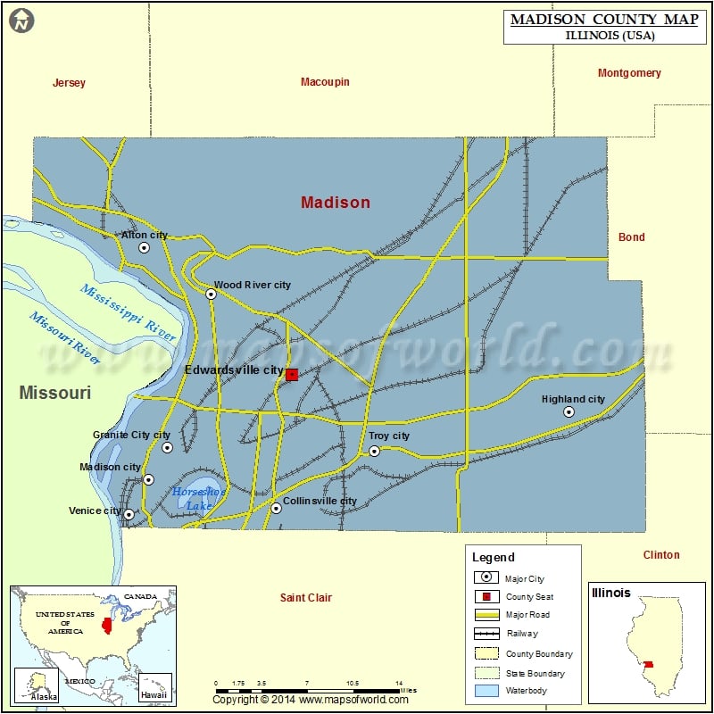
Cities in Madison County
| City | Population | Latitude | Longitude |
|---|---|---|---|
| Alhambra village | 681 | 38.887637 | -89.735887 |
| Alton city | 27865 | 38.903304 | -90.15233 |
| Bethalto village | 9521 | 38.901635 | -90.047161 |
| Collinsville city | 25579 | 38.676773 | -90.005293 |
| East Alton village | 6301 | 38.88382 | -90.107587 |
| Edwardsville city | 24293 | 38.79245 | -89.988285 |
| Glen Carbon village | 12934 | 38.757974 | -89.984046 |
| Godfrey village | 17982 | 38.958245 | -90.215979 |
| Granite City city | 29849 | 38.729818 | -90.126031 |
| Grantfork village | 337 | 38.828766 | -89.667236 |
| Hamel village | 816 | 38.889164 | -89.842604 |
| Hartford village | 1429 | 38.821214 | -90.091012 |
| Highland city | 9919 | 38.761138 | -89.681302 |
| Holiday Shores | 2882 | 38.922637 | -89.936039 |
| Livingston village | 858 | 38.968134 | -89.764265 |
| Madison city | 3891 | 38.702124 | -90.147602 |
| Marine village | 960 | 38.78715 | -89.7782 |
| Maryville village | 7487 | 38.726374 | -89.9643 |
| Mitchell | 1356 | 38.763159 | -90.081307 |
| New Douglas village | 319 | 38.969615 | -89.666307 |
| Pontoon Beach village | 5836 | 38.720785 | -90.059745 |
| Rosewood Heights | 4038 | 38.888489 | -90.071881 |
| Roxana village | 1542 | 38.831537 | -90.046541 |
| South Roxana village | 2053 | 38.813922 | -90.060527 |
| St. Jacob village | 1098 | 38.719589 | -89.76779 |
| Troy city | 9888 | 38.726901 | -89.896751 |
| Venice city | 1890 | 38.671963 | -90.168859 |
| Williamson village | 230 | 38.987231 | -89.764378 |
| Wood River city | 10657 | 38.863313 | -90.077399 |
| Worden village | 1044 | 38.931376 | -89.840376 |
Golf Courses in Madison County
| Name of Golf Course | Latitude | Longitude |
|---|---|---|
| American Legion Post Golf Course-Edwardsville | 38.761116 | -90.008988 |
| Arlington Greens Golf Course-Granite City | 38.70783 | -90.03856 |
| Belk Park Golf Course-Wood River | 38.872776 | -90.04332 |
| Cloverleaf Golf Course Inc-Alton | 38.925135 | -90.104884 |
| Fox Creek Golf Club-Edwardsville | 38.849982 | -89.955501 |
| Gateway National Golf Links-Madison | 38.66304 | -90.142039 |
| Highland Country Club-Highland | 38.747305 | -89.680319 |
| Oak Brook Golf Club-Edwardsville | 38.830821 | -89.838008 |
| Rivers’ Edge Golf Course-Granite City | 38.700949 | -90.178847 |
| Robert P. Wadlow Municipal Golf Course-Alton | 38.917797 | -90.161246 |
| Rock Springs Golf Course-Alton | 38.903523 | -90.155426 |
| Rolling Hills Golf Course-Godfrey | 38.949733 | -90.214842 |
| Spencer T Olin Community Golf Course-Alton | 38.910285 | -90.108249 |
| Stonebridge Golf Club-Maryville | 38.723163 | -89.991175 |
| Sunset Hills Country Club-Edwardsville | 38.774841 | -89.992556 |
| The Legacy Golf Course-Granite City | 38.724267 | -90.086238 |
| The Woodlands Golf Club-Alton | 38.930308 | -90.134275 |
 Wall Maps