Amsterdam City Map written by: Fredjans
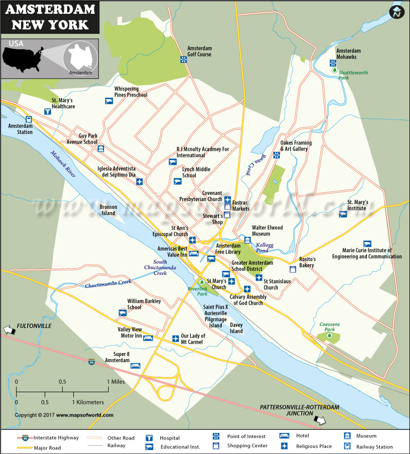
Located in Montgomery County, New York, USA, Amsterdam is a city that covers a total area of 6.3 sq mi. It is located at an elevation of 361 ft. According to the US Census Bureau, the city’s total population is 18,620 while the population density is 3,176.3/sq mi. It borrows its name from Netherlands’ capital, and concerning its specific location, it is set on both sides of Mohawk River.
The southern part of the city has the New York State Thruway which connects Pattersonville-Rotterdam junction and Fultonville. Another major road, New York State Route 30, crosses the Mohawk River from north to connect to the thruway in the south side of the river. This road also intersects New York State Route 67 and New York State Route 5 which are east-west roads.
The city is also served by a railway which runs from south east to north west along the northern side of the river. The railway station (Amsterdam Station) is located in the north west end of the city.
When it comes to hotels, there is the Americas Best Value Inn in the heart of the city. The other hotels, Valley View Motor Inn and Super 8 Amsterdam, are located in the southern part of the city.
The city’s shopping centers are located at the central business district, and include Fastrac Markets, Stewart’s Shop and Rosito’s Bakery.
Regarding educational institutions, there are schools and colleges in almost all the corners of the city. The northern part has Whispering Pines Preschool, R.J. Mcnulty Academy for International and Lynch Middle School. The southern side has William Barkley School while the eastern side has St. Mary’s Institute and Marie Curie Institute of Engineering and Communication. The central area has Amsterdam Free Library and Greater Amsterdam School.
As for the hospitals, there is St. Mary’s Healthcare in the north western area.
On the side of religion, the city has Iglesia Adventista del Septimo Dia in the north western area and Our Lady of Mt Carmel in the southern part. The central region has Calvary Assembly of God Church, St Ann’s Episcopal Church, St. Mary’s Church, St. Staniscluas Church and Covenant Presbyterian Church.
Other places of interest on the Amsterdam Map include: Amsterdam Golf Course (northern end), Coessens Park (South East), Riverlink Park (central region), Amsterdam Mohawks & Shuttleworth Park (North East), Oakes Framing & Art Galley (central region) and Walter Elwood Museum (central region).
In the Mohawk River, there are islands such as Davey, Bronson and Saint Pius X Auriesville Pilgrimage. Apart from the Mohawk River, the city boasts other water features such as Chuctanunda Creek, Bunn Creek and Kellogg Pond.
IW09.03.2017
 Wall Maps
