- Missouri Counties - Missouri County Map, Map of Missouri Counties
- Major Cities of Missouri - Kansas City, St Louis, Branson
- Neighbouring States - Iowa, Illinois, Kentucky, Tennessee, Arkansas, Oklahoma, Kansas, Nebraska
- Regional Maps - Map of USA
- Other Missouri Maps - Missouri Map, Where is Missouri, Missouri Physical Map, Missouri Lat Long Map, Missori Zip Code Map, Missouri Area Code Map
Airports in Missouri
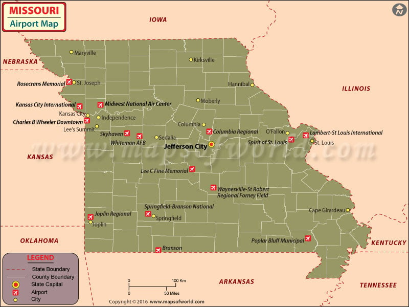
There are 131 airports in Missouri for public use. One can book the tickets of these airlines online by visiting their respective sites. Some airlines also offer special fares and discounts for online booking of their tickets. The international airports in Missouri are the Kansas City International Airport and the Lambert-St. Louis International Airport. The Kansas City International Airport is an important connecting point for many American fliers, with nearly 10 million passengers using its services annually. The amenities available at this airport in Missouri include many eateries in different concourses, business centers, ATMs, news and gifts shops, and baggage claim. The airport is also disabled-friendly and has TTY phones, Braille signage, visual paging monitors, and elevators. The airlines that serve this airport are Air Canada, Continental Airlines, Midwest, United Airlines, Southwest Airlines, US Airways, Delta Airlines, Frontier Airlines, American Airlines, and America West Airlines.shine shops, coffee shops, chapel, smoking booths, post office, a bank, a bar and restaurants, and ice cream stores. The Lambert-St. Louis International Airport sees millions of people use its services annually.
The Lambert-St. Louis International Airport in Missouri also provides assistance to the disabled. Some of the airlines that serve at this airport in Missouri are Ryan Air, Comair, Air Canada, US AirwaysExpress, Continental Express, Allegiant Airlines, Skyway, Southwest, American, Northwest, united Express, US 3000, America West, Go Jet, and Delta.
The other important airports in Missouri are at Kirtsville, trenton, Chillicothe, St. Joseph, Cameron, Marshall, Moberly, Boonville, Columbia, Fefferson City, St. Charles, St. Louis, Rolla, Lebanon, Nevada, Lamar, Jpolin, Springfield, Cape Girardeau, Sikeston, Jopin, Ava, West Plains, Gainesville, Poplar Bluff, New Madrid, Sikeston, Cape Girardeau.
Maps of Major Airports in Missouri
List of Airports in Missouri
| Airport Name | City | Coordinates |
|---|---|---|
| Columbia Regional Airport | Columbia | 38°49′05″N 092°13′11″W |
| Joplin Regional Airport | Joplin | 37°09′06″N 094°29′54″W |
| Kansas City International Airport | Kansas City | 39°17′51″N 94°42′50″W |
| Springfield-Branson National Airport | Springfield | 37.245556, -93.388611 |
| Lambert-St. Louis International Airport | St. Louis | 38°44′50″N 090°21′41″W |
| Cape Girardeau Regional Airport | Cape Gardenia | 37°13′31″N 089°34′15″W |
| Waynesville-St. Robert Regional Airport | Fort Leonard Wood / Waynesville | 37°44′30″N 092°08′27″W |
| Kirksville Regional Airport | Kirksville | 40°05′36″N 092°32′42″W |
| Albany Municipal Airport | Albany | 40°15′44″N 094°20′20″W |
| Ava Bill Martin Memorial Airport | Ava | 36°58′19″N 092°40′55″W |
| Bethany Memorial Airport | Bethany | 40°16′37″N 094°00′27″W |
| Bismarck Memorial Airport | Bismarck | 37°45′32″N 090°37′00″W |
| M. Graham Clark Downtown Airport | Branson / Point Lookout | 36°37′33″N 093°13′44″W |
| Branson West Municipal Airport | Branson West | 36°41′55″N 093°24′08″W |
| Buffalo Municipal Airport | Buffalo | 37°39′15″N 093°05′13″W |
| Mississippi County Airport | Charleston | 36°50′32″N 089°21′35″W |
| Festus Memorial Airport | Festus | 38°11′42″N 090°23′08″W |
| Lexington Municipal Airport | Lexington | 39°12′35″N 093°55′41″W |
| Lincoln Municipal Airport | Lincoln | 38°24′08″N 093°19′56″W |
| Rankin Airport | Maryville | 40°19′54″N 094°50′05″W |
| Monroe City Regional Airport | Monroe City | 39°38′04″N 091°43′37″W |
| Tan-Tar-A Resort Seaplane Base | Osage Beach | 38°08′00″N 092°44′01″W |
| Osceola Municipal Airport | Osceola | 38°01′07″N 093°41′36″W |
| Washington County Airport | Potosi | 37°55′45″N 090°43′53″W |
| Richland Municipal Airport | Richland | 37°52′30″N 092°24′29″W |
| Rolla Downtown Airport | Rolla | 37°56′08″N 091°48′49″W |
| Shelby County Airport | Shelbyville | 39°49′00.14″N 92°03′00.62″W |
| Downtown Airport | Springfield | 37°13′18″N 093°14′52″W |
| Stockton Municipal Airport | Stockton | 37°39′37″N 093°49′01″W |
| Unionville Municipal Airport | Unionville | 40°32′25″N 093°01′32″W |
 Wall Maps