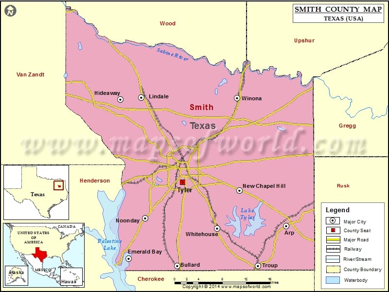
Check this Texas County Map to locate all the state’s counties in Texas Map. Mountain Peaks in Smith County Mountain Peak/Hill Elevation [Meter] Goodman Mountain 192 Mount Sinai 166 Starrville Mountain 196 Todd…
Check this Texas County Map to locate all the state’s counties in Texas Map .
Mountain Peaks in Smith County
Mountain Peak/Hill
Elevation [Meter]
Goodman Mountain
192
Mount Sinai
166
Starrville Mountain
196
Todd Mountain
185
More Maps of Smith County
Airports in Smith County
Airport Name
Basslake Airport
Dps-Tyler Heliport
Fraser Farm Airport
Headwind Heliport
Ina Road Heliport
Kay Ranch Airport
Mother Frances Hospital Heliport
Mother Frances Hospital Heliport
Nuttall Airport
Oaks Airport
Pineridge STOLport
Trap Travelstead Field
Tyler Pounds Regional Airport
Cities in Smith County
City
Population
Latitude
Longitude
Arp city
970
32.227901
-95.053624
Bullard town
2463
32.145116
-95.319474
Emerald Bay
1047
32.160166
-95.438039
Hideaway city
3083
32.488959
-95.45785
Lindale city
4818
32.493226
-95.406653
New Chapel Hill city
594
32.299855
-95.167191
Noonday city
777
32.243999
-95.396927
Troup city
1869
32.145017
-95.122366
Tyler city
96900
32.315402
-95.305009
Whitehouse city
7660
32.221559
-95.221805
Winona town
576
32.492752
-95.172962
Golf Courses in Smith County
Name of Golf Course
Latitude
Longitude
Arrowhead Golf Club-Tyler
32.362532
-95.106436
Cascades Golf Club-Tyler
32.316104
-95.388961
Emerald Bay Club-Bullard
32.157607
-95.435896
Garden Valley Golf Resort-Lindale
32.480511
-95.537056
Hide A Way Lake Golf Course-Hideaway
32.471072
-95.455584
Hilltop Country Club-Troup
32.15326
-95.105444
Hollytree Country Club-Tyler
32.276424
-95.31943
Peach Tree Golf Club-Bullard
32.169395
-95.326153
Pine Springs Golf Course-Tyler
32.428172
-95.265161
The Challenge At Gladewater-Gladewater
32.48534
-95.041969
Willow Brook Country Club-Tyler
32.351562
-95.335587

 Wall Maps