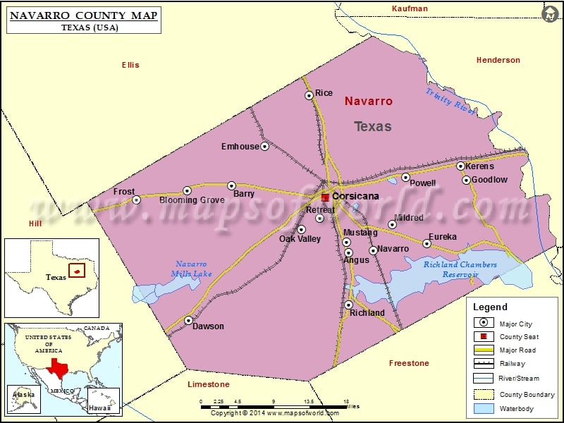
Navarro County Map, Texas
Check this Texas County Map to locate all the state’s counties in Texas Map. Mountain Peaks in Navarro County Mountain Peak/Hill Elevation [Meter] Black Hills 139 Twilight Home 126 Airports in Navarro County…
Check this Texas County Map to locate all the state’s counties in Texas Map .
Mountain Peaks in Navarro County
Mountain Peak/Hill
Elevation [Meter]
Black Hills
139
Twilight Home
126
Airports in Navarro County
Airport Name
Anxiety Aerodrome
Byrt Airport
C David Campbell Field Corsicana Municipal Airport
Coyote Field
Hackberry Airport
Hancock Airport
Jtj Ranch Airport
Knapp Pecan Orchard Airpark
Rainbow Field
Roscoe Mc Connico Airport
Smith Airport
The Homestead Airport
Cities in Navarro County
City
Population
Latitude
Longitude
Angus city
414
31.997623
-96.426965
Barry city
242
32.099902
-96.637764
Blooming Grove town
821
32.092362
-96.717295
Corsicana city
23770
32.082156
-96.468533
Dawson town
807
31.89412
-96.715089
Emhouse town
133
32.160703
-96.577203
Eureka city
307
32.012222
-96.285669
Frost city
643
32.078807
-96.808536
Goodlow city
200
32.109065
-96.215144
Kerens city
1573
32.130807
-96.225125
Mildred town
368
32.041124
-96.348339
Mustang town
21
32.013531
-96.430309
Navarro town
210
32.00079
-96.382516
Oak Valley town
368
32.033101
-96.511618
Powell town
136
32.112925
-96.323695
Retreat town
377
32.050501
-96.478763
Rice city
923
32.238805
-96.497824
Richland town
264
31.923613
-96.428439
Golf Courses in Navarro County
Name of Golf Course
Latitude
Longitude
Corsicana Country Club-Corsicana
32.121089
-96.482846
Oaks Trail Golf Club-Corsicana
32.12012
-96.465012

 Wall Maps