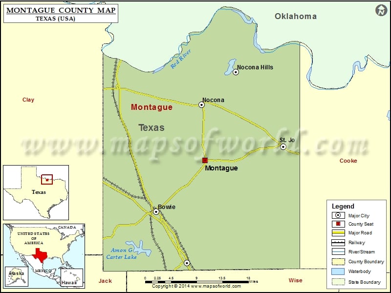
Montague County Map, Texas
Check this Texas County Map to locate all the state’s counties in Texas Map. Mountain Peaks in Montague County Mountain Peak/Hill Elevation [Meter] Benton Hill 324 Blue Mound 395 Blue Mound 312 Brushy…
Check this Texas County Map to locate all the state’s counties in Texas Map .
Mountain Peaks in Montague County
Mountain Peak/Hill
Elevation [Meter]
Benton Hill
324
Blue Mound
395
Blue Mound
312
Brushy Mound
363
Buzzard Roost Knob
345
Colt Mountain
295
Cougar Mountain
348
Dead Ox Mound
320
Double Mounds
288
Dye Mound
388
Flag Mound
283
Gordon Mountain
393
Grindstone Mountain
339
Jack Mound
348
Jim Ned Lookout
394
McCracken Mound
343
Mount View
393
Newby Mound
368
Norton Mountain
336
Queens Peak
352
Rattlesnake Mountain
339
Red Mound
296
Snake Hill
299
Sugarloaf Mound
356
Tadlock Hill
362
Airports in Montague County
Airport Name
Bowie Municipal Airport
Flying F Airport
Nocona Airport
Sky Acres Airport
Western Sky Airport
Cities in Montague County
City
Population
Latitude
Longitude
Bowie city
5218
33.556668
-97.84401
Montague
304
33.665271
-97.720954
Nocona city
3033
33.783556
-97.73017
Nocona Hills
675
33.852403
-97.643506
St. Jo city
1043
33.695023
-97.523071
Sunset
497
33.44795
-97.766354
Golf Courses in Montague County
Name of Golf Course
Latitude
Longitude
Bowie Golf Club-Bowie
33.476711
-97.86807
Indian Oaks Golf Club-Nocona
33.783879
-97.735072
Nocona Hills Golf Course-Nocona
33.835808
-97.630899
Prairie Oaks Ranch-Bowie
33.549757
-97.846921

 Wall Maps