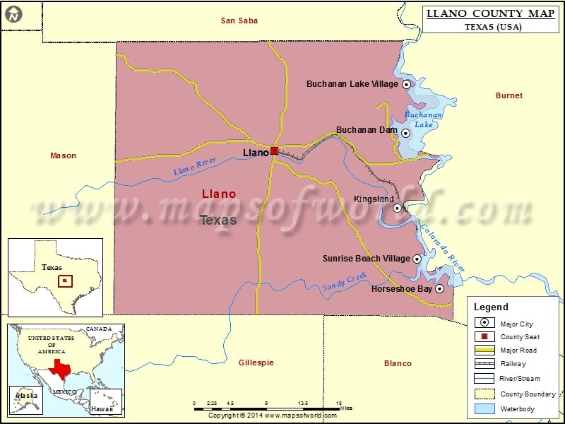
Check this Texas County Map to locate all the state’s counties in Texas Map. Mountain Peaks in Llano County Mountain Peak/Hill Elevation [Meter] Babyhead Mountain 493 Bachelor Peak 393 Barker Hill 482 Bear…
Check this Texas County Map to locate all the state’s counties in Texas Map .
Mountain Peaks in Llano County
Mountain Peak/Hill
Elevation [Meter]
Babyhead Mountain
493
Bachelor Peak
393
Barker Hill
482
Bear Mountain
469
Blount Mountain
461
Bowie Mountain
452
Briscoe Mountain
497
Bullhead Mountain
516
Bunker Hill
457
Cap Mountain
377
Cedar Mountain
544
Cowen Rocks
341
Dancer Peak
523
Deer Mountain
480
Devils Toenail
449
Dunman Mountain
387
Dutch Mountain
483
Enchanted Rock
553
Fool Mountain
459
Fox Mountain
412
Granite Knob
398
Graze Mountain
474
Green Mountain
409
Hardin Hills
321
Hickory Mountain
483
High Rock
511
Hobson Mountain
469
Hog Mountain
414
Horse Mountain
444
House Mountain
554
Kings Mountain
504
Little Murray Mountain
323
Little Sandy Mountain
286
Lockhart Mountain
444
Lone Mountain
474
Lone Oak Mountain
566
Long Mountain
409
Lovers Rock
474
Lucky Mountain
476
Magill Mountain
518
McBrown Mountain
452
Mesquite Hill
314
Miller Mountain
397
Moore Peak
383
Morris Hill
414
Packsaddle Mountain
476
Panther Rock
504
Phillips Rock
430
Pluto Mountain
499
Point Peak
447
Potato Hill
410
Prairie Mountain
561
Putman Mountain
569
Pyramid Rock
533
Quartz Knob
343
Railbrake Mountain
480
Red Mountain
369
Riley Mountains
482
Rough Mountain
444
Sandstone Mountain
421
Sandy Mountain
316
Sharp Mountain
473
Slick Mountain
466
Smoothingiron Mountain
560
Town Peak
388
Walker Peak
470
Watch Mountain
478
Watson Mountain
478
Wolf Mountain
405
Wright Knobs
542
Yearling Head Mountain
513
Airports in Llano County
Airport Name
Bullhead Heliport
Camp Longhorn Airport
Flying D Airport
Flying H Ranch Airport
Horseshoe Bay Resort Airpark
Kingsland Estates Airport
Llano Municipal Airport
Mc David Ranch Airport
Shirley Williams Airport
Sunrise Beach Airport
Cities in Llano County
City
Population
Latitude
Longitude
Buchanan Dam
1519
30.7807
-98.439231
Buchanan Lake Village
692
30.856572
-98.437781
Horseshoe Bay city
3418
30.53636
-98.378245
Kingsland
6030
30.66507
-98.454433
Llano city
3232
30.753432
-98.674921
Sunrise Beach Village city
713
30.586155
-98.418724
Golf Courses in Llano County
Name of Golf Course
Latitude
Longitude
Blue Lake Golf Club-Horseshoe Bay
30.540541
-98.366186
Caprock At Horseshoe Bay Resort-Horseshoe Bay
30.545251
-98.401545
Escondido Golf and Lake Club-Horseshoe Bay
30.534213
-98.379669
Llano Municipal Golf Course-Llano
30.747331
-98.711204
Packsaddle Country Club-Kingsland
30.64147
-98.465629
Slick Rock At Horseshoe Bay Resort-Horseshoe Bay
30.537893
-98.369905

 Wall Maps