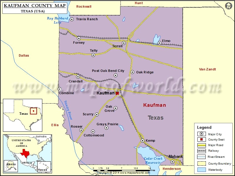
Kaufman County Map, Texas
Check this Texas County Map to locate all the state’s counties in Texas Map. Mountain Peaks in Kaufman County Mountain Peak/Hill Elevation [Meter] Breezy Hill 165 Sand Hill 117 Airports in Kaufman County…
Check this Texas County Map to locate all the state’s counties in Texas Map .
Mountain Peaks in Kaufman County
Mountain Peak/Hill
Elevation [Meter]
Breezy Hill
165
Sand Hill
117
Airports in Kaufman County
Airport Name
Airpark East Airport
Baum Airport
Bennetts Airport
Charlton Methodist Hospital Heliport
Connies Aviation Airport
Erco Field
Hall Airport
Moore Airport
Smith Field
Sunset Airport
Terrell Community Hospital Heliport
Terrell Municipal Airport
Twin Acres Airport
Wings Over Texas Airport
Cities in Kaufman County
City
Population
Latitude
Longitude
Combine city
1942
32.591012
-96.520249
Cottonwood city
185
32.460877
-96.39986
Crandall city
2858
32.628083
-96.453419
Elmo
768
32.731481
-96.158998
Forney city
14661
32.747149
-96.452089
Grays Prairie village
337
32.472634
-96.350725
Kaufman city
6703
32.577515
-96.312084
Kemp city
1154
32.432421
-96.22058
Mabank town
3035
32.368225
-96.114015
Oak Grove town
603
32.532109
-96.318188
Oak Ridge town
495
32.64289
-96.257315
Post Oak Bend City town
595
32.632568
-96.318027
Rosser village
332
32.464998
-96.442159
Scurry town
681
32.512822
-96.385437
Talty town
1535
32.69451
-96.398439
Terrell city
15816
32.730797
-96.287807
Travis Ranch
2556
32.802546
-96.475883
Golf Courses in Kaufman County
Name of Golf Course
Latitude
Longitude
Cedar Creek Country Club-Kemp
32.378518
-96.166386
Creekview Golf Club-Crandall
32.62872
-96.449629
Indian Oaks Golf Club-Kemp
32.394115
-96.368555
King’s Creek Golf Club-Kemp
32.407805
-96.249675
Oak Grove Golf Course-Terrell
32.752959
-96.30128
Pecan Ridge Golf Club-Scurry
32.520971
-96.441832

 Wall Maps