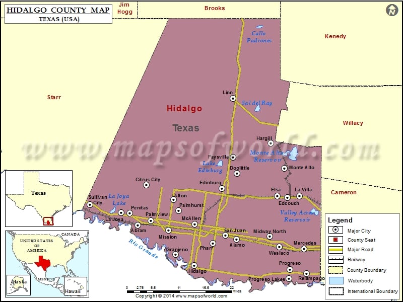
Hidalgo County Map, Texas
Check this Texas County Map to locate all the state’s counties in Texas Map. Mountain Peaks in Hidalgo County Mountain Peak/Hill Elevation [Meter] Harmony Hill 25 Sunrise Hill 26 Airports in Hidalgo County…
Check this Texas County Map to locate all the state’s counties in Texas Map .
Mountain Peaks in Hidalgo County
Mountain Peak/Hill
Elevation [Meter]
Harmony Hill
25
Sunrise Hill
26
Airports in Hidalgo County
Airport Name
Cannon Aviation Airport
Flying ‘K’ Ranch Ultralightport
Gross Private Airport
Knapp Medical Center Heliport
Mc Allen Miller International Airport
Mid Valley Airport
Mid-Valley Dusters Inc Airport
Moore Airpark
Moore Field
Norman & White Airport
Old Reb Airport
Palmview Police Department
Progreso Airport
Putz Airport
Skalitsky Airport
South Texas International At Edinburg Airport
Tgp 409 Heliport
Cities in Hidalgo County
City
Population
Latitude
Longitude
Abram
2067
26.217982
-98.417883
Alamo city
18353
26.179768
-98.11824
Alton city
12341
26.288846
-98.311383
Cesar Chavez
1929
26.310482
-98.114259
Citrus City
2321
26.328071
-98.392314
Cuevitas
40
26.258492
-98.578721
Doffing
5091
26.278779
-98.38558
Donna city
15798
26.146739
-98.055933
Doolittle
2769
26.359771
-98.116769
Edcouch city
3161
26.293723
-97.963089
Edinburg city
77100
26.315584
-98.163713
Elsa city
5660
26.297885
-97.993759
Faysville
439
26.404
-98.12953
Granjeno city
293
26.137396
-98.303125
Hargill
877
26.442289
-98.014559
Havana
407
26.250734
-98.509008
Heidelberg
1725
26.183077
-97.885018
Hidalgo city
11198
26.106193
-98.249167
Indian Hills
2591
26.212231
-97.91837
La Blanca
2488
26.304796
-98.028598
La Homa
11985
26.277075
-98.35777
La Joya city
3985
26.25178
-98.469883
La Villa city
1957
26.297677
-97.926879
Laguna Seca
266
26.279302
-97.926182
Linn
801
26.566198
-98.129745
Llano Grande
3008
26.130806
-97.968777
Lopezville
4333
26.248763
-98.157501
Los Ebanos
335
26.24229
-98.557874
McAllen city
129877
26.218568
-98.245204
Mercedes city
15570
26.153298
-97.913871
Midway North
4752
26.188014
-98.017328
Midway South
2239
26.156676
-98.020853
Mila Doce
6222
26.222915
-97.960055
Mission city
77058
26.203295
-98.32282
Monte Alto
1924
26.374373
-97.972724
Muniz
1370
26.257823
-98.089671
Murillo
7344
26.26467
-98.126134
North Alamo
3235
26.215804
-98.126048
Olivarez
3827
26.228547
-97.993087
Palmhurst city
2607
26.258014
-98.295318
Palmview city
5460
26.23025
-98.37898
Palmview South
5575
26.216025
-98.37705
Penitas city
4403
26.250784
-98.442552
Perezville
5376
26.239542
-98.402326
Pharr city
70400
26.168803
-98.190474
Progreso city
5507
26.096147
-97.956588
Progreso Lakes city
240
26.071255
-97.958804
Relampago
132
26.085088
-97.905872
San Carlos
3130
26.295668
-98.063053
San Juan city
33856
26.190182
-98.152191
Scissors
3186
26.133333
-98.047489
South Alamo
3361
26.151767
-98.107849
Sullivan City city
4002
26.275218
-98.564441
Villa Verde
874
26.130021
-97.995679
Weslaco city
35670
26.15902
-97.987829
West Sharyland
2309
26.272299
-98.339707
Golf Courses in Hidalgo County
Name of Golf Course
Latitude
Longitude
Alamo Country Club-Alamo
26.194803
-98.09957
Ebony Hills Public Golf Course-Edinburg
26.285011
-98.16677
LaFloresta Golf Course-Mercedes
26.212924
-97.914557
Llano Grande Golf Course-Mercedes
26.13783
-97.925849
Los Lagos Golf Club-Edinburg
26.287527
-98.138632
Martin Valley Ranch Golf Course-Mission
26.238658
-98.408772
McAllen Country Club-McAllen
26.18123
-98.229481
Meadow Creek in the Valley-Mission
26.196795
-98.350425
Mid Valley Golf Club-Mercedes
26.13873
-97.901739
Palacio Real at Monte Cristo-Edinburg
26.326526
-98.117263
Palm View Golf Course-McAllen
26.18944
-98.26494
Shary Municipal Golf Course-Mission
26.227344
-98.31568
The Club At Cimarron-Mission
26.215431
-98.337143
Tierra Del Sol-Pharr
26.165244
-98.180906
Tierra Santa Golf Club-Weslaco
26.093775
-97.958594
Tropic Star RV Resort Golf Course-Pharr
26.175974
-98.187058
Village Executive Golf Course-Weslaco
26.127035
-97.959741

 Wall Maps