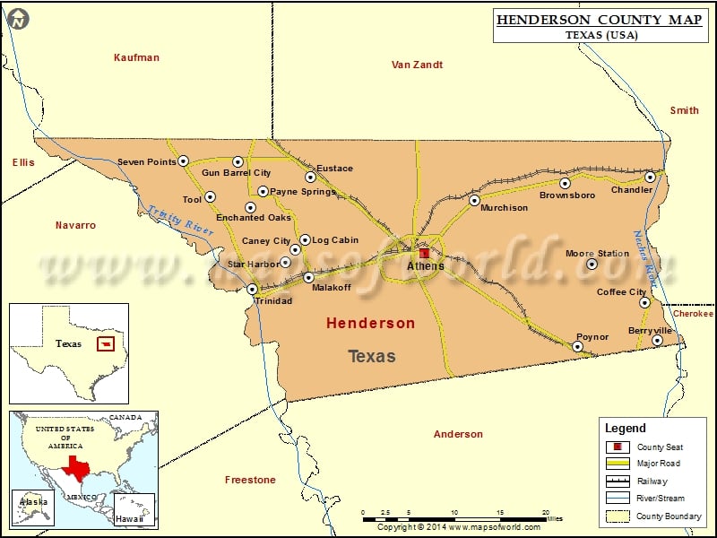
Henderson County Map, Texas
Check this Texas County Map to locate all the state’s counties in Texas Map. Mountain Peaks in Henderson County Mountain Peak/Hill Elevation [Meter] Cooper Mountain 192 Jennings Mountain 212 Melton Rock 196 Pine…
Check this Texas County Map to locate all the state’s counties in Texas Map .
Mountain Peaks in Henderson County
Mountain Peak/Hill
Elevation [Meter]
Cooper Mountain
192
Jennings Mountain
212
Melton Rock
196
Pine Grove Hill
151
Rock Hill
214
Tater Hill Mountain
234
More Maps of Henderson County
Airports in Henderson County
Airport Name
Aero Estates Airport
Athens Municipal Airport
Circle R Ranch Airport
Coon Creek Club Heliport
Echo Lake Airport
Etmc – Athens Heliport
Etmc – Gun Barrel City Heliport
Harbor Point Airport
Medical Emergency Gbc Heliport
Paradise Point Airport
Pickle Plantation Airport
Cities in Henderson County
City
Population
Latitude
Longitude
Athens city
12710
32.205209
-95.834857
Berryville town
975
32.087768
-95.466668
Brownsboro city
1039
32.29842
-95.613042
Caney City town
217
32.209618
-96.038146
Chandler city
2734
32.306486
-95.478115
Coffee City town
278
32.138291
-95.487094
Enchanted Oaks town
326
32.266601
-96.108989
Eustace city
991
32.307544
-96.013802
Gun Barrel City city
5672
32.327678
-96.128817
Log Cabin city
714
32.223082
-96.022261
Malakoff city
2324
32.17276
-96.016246
Moore Station city
201
32.190556
-95.570392
Murchison city
594
32.275171
-95.756069
Payne Springs town
767
32.286257
-96.0909
Poynor town
305
32.079342
-95.592372
Seven Points city
1455
32.329026
-96.214248
Star Harbor city
444
32.192781
-96.054197
Tool city
2240
32.280348
-96.172532
Trinidad city
886
32.156204
-96.105355
Golf Courses in Henderson County
Name of Golf Course
Latitude
Longitude
Athens Country Club-Athens
32.193359
-95.861656
Echo Creek Country Club-Murchison
32.24048
-95.660715
Pinnacle Country Club-Mabank
32.221251
-96.074849
Star Harbor Golf Club-Malakoff
32.194514
-96.054011

 Wall Maps