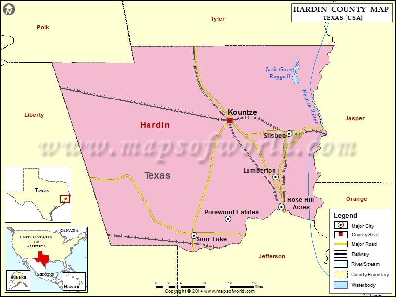
Check this Texas County Map to locate all the state’s counties in Texas Map. Mountain Peaks in Hardin County Mountain Peak/Hill Elevation [Meter] Caney Head 37 More Maps of Hardin County Hardin County…
Check this Texas County Map to locate all the state’s counties in Texas Map.
Mountain Peaks in Hardin County
| Mountain Peak/Hill |
Elevation [Meter] |
| Caney Head |
37 |
More Maps of Hardin County
Airports in Hardin County
| Airport Name |
| Hawthorne Field |
| Station 40 Heliport |
Cities in Hardin County
| City |
Population |
Latitude |
Longitude |
| Kountze city |
2123 |
30.372432 |
-94.315944 |
| Lumberton city |
11943 |
30.256436 |
-94.207134 |
| Pinewood Estates |
1678 |
30.169173 |
-94.320648 |
| Rose Hill Acres city |
441 |
30.193305 |
-94.193085 |
| Silsbee city |
6611 |
30.345622 |
-94.176404 |
| Sour Lake city |
1813 |
30.135659 |
-94.402322 |
Golf Courses in Hardin County
| Name of Golf Course |
Latitude |
Longitude |
| Idylwild Golf Club-Sour Lake |
30.156462 |
-94.317742 |
| Silsbee Country Club-Silsbee |
30.384066 |
-94.296001 |
| Wildwood Golf Course-Village Mills |
30.494377 |
-94.397183 |
National Parks in Hardin County
| Name of Park |
Latitude |
Longitude |
| Big Thicket N PRES |
30.344357 |
-94.267845 |
| Big Thicket N PRES |
30.606163 |
-94.682732 |
| Big Thicket N PRES |
30.539315 |
-94.344574 |
| Big Thicket N PRES |
30.458536 |
-94.386207 |

 Wall Maps