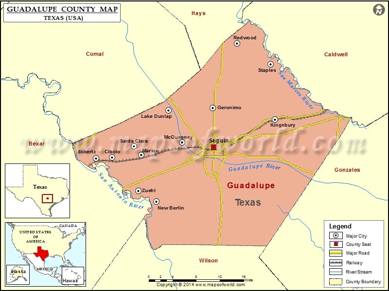
Guadalupe County Map, Texas
Check this Texas County Map to locate all the state’s counties in Texas Map. Mountain Peaks in Guadalupe County Mountain Peak/Hill Elevation [Meter] Capote Hills 181 Capote Knob 209 Harborth Hill 214 Kings…
Check this Texas County Map to locate all the state’s counties in Texas Map .
Mountain Peaks in Guadalupe County
Mountain Peak/Hill
Elevation [Meter]
Capote Hills
181
Capote Knob
209
Harborth Hill
214
Kings Hill
228
Mill Creek Hills
214
Airports in Guadalupe County
Airport Name
Alison Air Park
Cibolo Sea-Willo Airpark
Cunningham Airpark
Elm Creek Airpark
Gary’s Airport
Glen Beicker Ranch Airport
Guadalupe Hospital Heliport
H M Ranch Airport
Heritage Airfield
Hilltop Ranch Airport
Huber Airpark Civic Club Llc Airport
Joe Fleming Field
Lackorn Airport
Moltz Airport
New Braunfels Municipal Airport
Old Kingsbury Aerodrome
Randolph Air Force Base Auxiliary Airport
Saint’s Strip Ultralightport
Woodstone Corporation Heliport
Zuehl Airport
Cities in Guadalupe County
City
Population
Latitude
Longitude
Cibolo city
15349
29.577312
-98.23569
Geronimo
1032
29.672801
-97.968569
Kingsbury
782
29.648381
-97.817697
Lake Dunlap
1934
29.668048
-98.077577
Marion city
1066
29.572568
-98.142941
McQueeney
2545
29.599433
-98.04379
New Berlin city
511
29.47216
-98.106595
Redwood
4338
29.810025
-97.910301
Santa Clara city
725
29.592058
-98.160795
Schertz city
31465
29.567607
-98.257402
Seguin city
25175
29.588812
-97.966272
Staples city
267
29.766346
-97.827857
Zuehl
376
29.496406
-98.151105
Golf Courses in Guadalupe County
Name of Golf Course
Latitude
Longitude
Birdee’s Golf Center & Driving Range-New Braunfels
29.640719
-98.122601
Golf Club of Sequin-Sequin
29.548708
-97.981458
Max Starcke Park Golf Club-Sequin
29.556182
-97.964119
Northcliffe Country Club-Cibolo
29.624539
-98.227162
The Bandit Golf Club-New Braunfels
29.625497
-98.064913

 Wall Maps