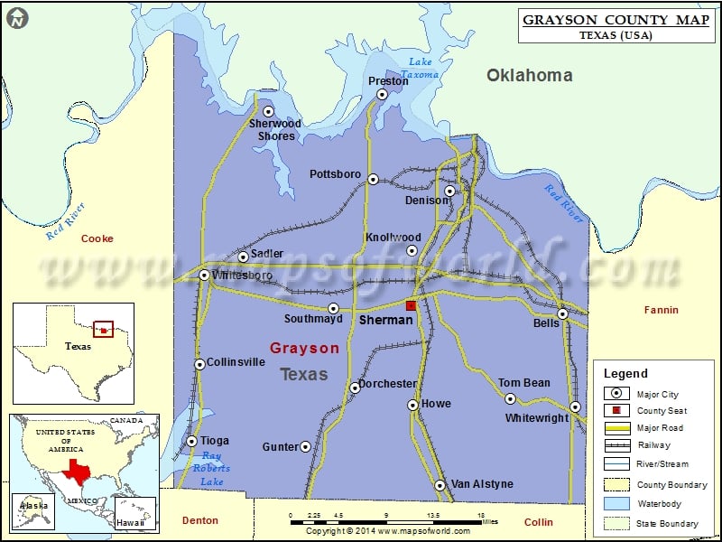
Grayson County Map, Texas
Check this Texas County Map to locate all the state’s counties in Texas Map. Mountain Peaks in Grayson County Mountain Peak/Hill Elevation [Meter] Brushy Mound 264 Airports in Grayson County Airport Name Beaver…
Check this Texas County Map to locate all the state’s counties in Texas Map .
Mountain Peaks in Grayson County
Mountain Peak/Hill
Elevation [Meter]
Brushy Mound
264
Airports in Grayson County
Airport Name
Beaver Creek Airport
Bevoni-Flying B Airport
Bridges Field
Brushy Creek Airport
Butler Airport
Cedar Mills Airport
Department of Public Safety Heliport
Diamond J Airport
Flying H Ranch Airport
Flying S Ranch Airport
Graham Field
Hitex Private Airport
Hoag Memorial Hospital Heliport
J-Bar Ranch Airport
Kahuna Bay Airport
Kidd-Private Airport
Lm Ranch Airport
Mag Drop Airport
Margaritaville Airport
Mc Keon Aviation Airport
Mc Manus Field
Morningstar Ranch Heliport
North Texas Rgnl/Perrin Field
Nuggs Flying M Airport
Pritchard Airport
Rowland R Airfield
Skida Patch Airport
Sudden Stop Airport
Texoma Medical Center Heliport
Tilghman Airport
Txaerosport Aerodrome
U U Ranch Airport
Wilson N Jones Memorial Hospital Heliport
Windwood Farm Airport
Cities in Grayson County
City
Population
Latitude
Longitude
Bells town
1392
33.616569
-96.412768
Collinsville town
1624
33.55921
-96.907585
Denison city
22682
33.75764
-96.565906
Dorchester city
148
33.53196
-96.699236
Gunter city
1498
33.464664
-96.764663
Howe town
2600
33.513427
-96.617598
Knollwood city
226
33.689259
-96.618462
Pottsboro town
2160
33.77158
-96.67072
Preston
2096
33.867086
-96.659521
Sadler city
343
33.68145
-96.848922
Sherman city
38521
33.624284
-96.615594
Sherwood Shores
1190
33.847774
-96.81466
Southmayd city
992
33.622724
-96.725223
Tioga town
803
33.471571
-96.919041
Tom Bean city
1045
33.520039
-96.484346
Van Alstyne city
3046
33.420451
-96.579487
Whitesboro city
3793
33.661311
-96.902073
Whitewright town
1604
33.510814
-96.395578
Golf Courses in Grayson County
Name of Golf Course
Latitude
Longitude
Denison Country Club-Denison
33.787361
-96.604247
Grayson College Golf Course-Denison
33.713828
-96.660011
Northern Challenge Golf Club-Sherman
33.662076
-96.704205
Rock Creek Golf Club-Gordonville
33.838722
-96.838248
Spirit Lake Golf Course-Tioga
33.465986
-96.920497
Stone Creek Country Club-Sherman
33.644896
-96.648564
Tanglewood Resort-Pottsboro
33.81881
-96.694649
The Bridges Golf Club-Gunter
33.430604
-96.704313
Woodlawn Country Club-Sherman
33.69265
-96.557829

 Wall Maps