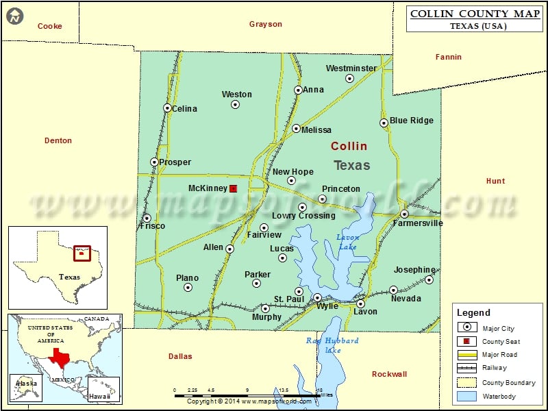
Collin County Map, Texas shows a region with a mix of urban and suburban landscapes, including the cities of Plano, Frisco, and Allen.
Collin County Map, Texas showing county boundaries and other details.
About Colllin County
Collin County is a county located in the northeastern part of the state of Texas , and its county seat is McKinney. The area is known for its strong economy, with a thriving business community in sectors such as technology, healthcare, and finance. The county is also home to several higher education institutions, including Collin College and the University of Texas at Dallas. The Collin County map shows major highways and transportation networks that connect the area to other parts of Texas and the United States. The region offers a high quality of life with excellent schools, parks, and cultural amenities.
Mountain Peaks in Collin County
Mountain Peak/Hill
Elevation [Meter]
Hays Hills
180
Airports in Collin County
Airport Name
AAF Heliport
Aero Country Airport
Aero Crafter Inc Heliport
Air Park Dallas Airport
Baylie Airport
Baylor Regional Medical Center At Plano Heliport
Bishop’s Landing Airport
Celina Field
Collin County Regional At Mc Kinney Airport
Drewery Airport
E D S Heliport
Eds Administration Nr 1 Heliport
Eds Hangar Heliport
Eds Heliport
Eds Superdrome Heliport
Flying T Ranch Airport
Four Winds Airport
Gmf Ranch Heliport
Jsi Airport
Kezer Air Ranch Airport
Kittyhawk Airport
Ladue Ranch Heliport
Lavon North Airport
Lmc Heliport
Mcp Heliport
Mullins Landing Airport
Pecks Heliport
Presbyterian Hospital Of Allen Heliport
Putman Heliport
Short Stop Airport
Square Air Airport
Tallows Field
Texas Health Presbyterian Hospital Plano Heliport
Windmill Hill Airport
Cities in Collin County
City
Population
Latitude
Longitude
Allen city
84246
33.108704
-96.673537
Anna city
8249
33.34777
-96.5525
Blue Ridge city
822
33.298304
-96.397715
Celina city
6028
33.319306
-96.785593
Fairview town
7248
33.140077
-96.612263
Farmersville city
3301
33.160131
-96.361337
Frisco city
116989
33.150755
-96.820134
Josephine city
812
33.061671
-96.317671
Lavon city
2219
33.025311
-96.439523
Lowry Crossing city
1711
33.170857
-96.544379
Lucas city
5166
33.095536
-96.582833
McKinney city
131117
33.198889
-96.667703
Melissa city
4695
33.289593
-96.555271
Murphy city
17708
33.018602
-96.610391
Nevada city
822
33.046267
-96.380956
New Hope town
614
33.21153
-96.563494
Parker city
3811
33.05587
-96.625988
Plano city
259841
33.050215
-96.748641
Princeton city
6807
33.184114
-96.507823
Prosper town
9423
33.239419
-96.802767
St. Paul town
1066
33.044325
-96.549997
Westminster
861
33.3649
-96.459817
Weston city
563
33.326094
-96.664539
Wylie city
41427
33.035324
-96.517149
Golf Courses in Collin County
Name of Golf Course
Latitude
Longitude
Canyon Creek Country Club-Richardson
32.991286
-96.729497
Chase Oaks Golf Club-Plano
33.071569
-96.696087
Eldorado Country Club-McKinney
33.176569
-96.647179
Gentle Creek Golf Club-Prosper
33.247863
-96.754622
Gleneagles Country Club-Plano
33.027922
-96.809638
Heritage Ranch Golf & Country Club-Fairview
33.137865
-96.593174
Hurricane Creek Country Club-Anna
33.372943
-96.592243
Leatherwood Ranch Golf Course-Farmersville
33.156496
-96.350449
Los Rios Country Club-Plano
33.022911
-96.644486
Oak Hollow Golf Course-McKinney
33.227005
-96.612577
Pecan Hollow Golf Course-Plano
33.01305
-96.648317
Plantation Resort Golf Course-Frisco
33.116317
-96.781237
Prestonwood Country Club Hills Course-Plano
33.040141
-96.844093
Ridgeview Ranch Golf Club-Plano
33.111827
-96.744124
Stonebriar Country Club-Frisco
33.092521
-96.841735
Stonebridge Ranch Country Club-McKinney
33.188205
-96.692067
Stonebridge Ranch Country Club-McKinney
33.195795
-96.712147
The Golf Club At McKinney-McKinney
33.167729
-96.636017
The Golf Club At Twin Creeks-Allen
33.104154
-96.71042
The Practice Tee Golf Center-Richardson
32.992196
-96.756104
TPC At Craig Ranch-Mc Kinney
33.14022
-96.719825
WestRidge Golf Course-McKinney
33.195618
-96.735149

 Wall Maps