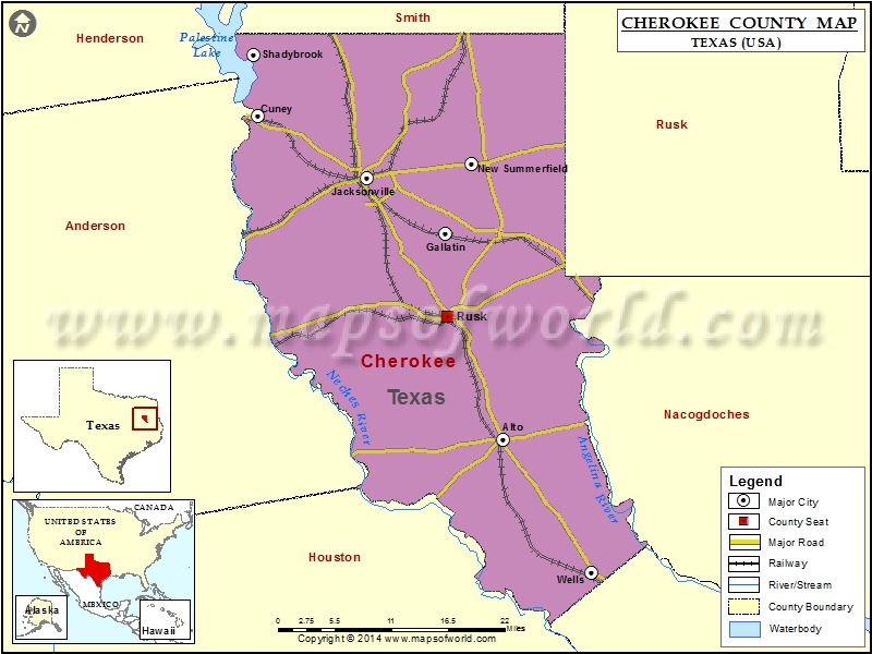
Cherokee County Map, Texas
Check this Texas County Map to locate all the state’s counties in Texas Map. Mountain Peaks in Cherokee County Mountain Peak/Hill Elevation [Meter] Bald Mountain 174 Big Hill 140 Bowman…
Check this Texas County Map to locate all the state’s counties in Texas Map .
Mountain Peaks in Cherokee County
Mountain Peak/Hill
Elevation [Meter]
Bald Mountain
174
Big Hill
140
Bowman Mountain
197
Bradford Mountain
214
Carter Mountain
196
Cary Lake Mountain
137
Casey Mountain
200
Collins Mountain
181
Fowler Hill
131
Ghent Mountain
207
Gibson Mountain
199
Gill Mountain
181
Graveyard Hill
159
Gray Mountain
209
Henry White Mountain
178
Jim Beard Mountain
141
Jones Mountain
199
Luker Mountain
194
Mount Hope
206
Pryor Mountain
210
Reagan Mountain
199
Rock Hill
142
Rocky Point
147
Round Mountain
191
Smith Mountain
184
Snow Mountain
201
Sunshine Mountain
183
Tater Hill
168
White Mountain
184
More Maps of Cherokee County
Airports in Cherokee County
Airport Name
Bolton Airport
Cherokee County Airport
Flying B Ranch Airport
French Field
Harrison Farm Airport
Tarrant Field
Taylor Ranch Airport
Cities in Cherokee County
City
Population
Latitude
Longitude
Alto town
1225
31.650982
-95.070785
Cuney town
140
32.037434
-95.414719
Gallatin city
419
31.896855
-95.152061
Jacksonville city
14544
31.964509
-95.261831
New Summerfield city
1111
31.980746
-95.114982
Rusk city
5551
31.797743
-95.149142
Shadybrook
1967
32.110799
-95.421219
Wells town
790
31.491559
-94.94732
Golf Courses in Cherokee County
Name of Golf Course
Latitude
Longitude
Birmingham Golf Club-Rusk
31.79697
-95.137129
Rolling Hills Golf Course-Rusk
31.720135
-95.099194
The Challenge At Eagle’s Bluff-Bullard
32.11773
-95.446899
The Woods At Jacksonville-Jacksonville
31.972224
-95.207303

 Wall Maps