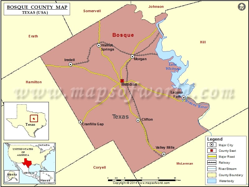
Check this Texas County Map to locate all the state’s counties in Texas Map. Mountain Peaks in Bosque County Mountain Peak/Hill Elevation [Meter] Arrs Mountain 295 Bee Mountain 232 Big…
Check this Texas County Map to locate all the state’s counties in Texas Map .
Mountain Peaks in Bosque County
Mountain Peak/Hill
Elevation [Meter]
Arrs Mountain
295
Bee Mountain
232
Big Bee Mountain
276
Brown Mountain
299
Cedar Mountain
362
Cranfills Mountain
344
Dinner Hill
302
Dunlap Hill
296
Flat Top Mountain
354
Flat Top Mountain
359
Gary Mountain
330
Godager Hill
294
Golden Mountain
307
Ilseng Mountain
342
Jackson Hill
372
Jenson Mountain
355
Johnson Peak
358
Kay Mountain
318
Little Bee Mountain
276
Norman Hill
269
Norse Hill
294
Norway Hill
281
Number Six Mountain
348
Pilot Knob
301
Powelldale Mountains
218
Rattlesnake Mountain
337
Rattlesnake Mountain
324
Rogstad Mountain
343
Round Mountain
298
Spencer Mountain
366
Sugarloaf Mountain
278
Airports in Bosque County
Airport Name
Bald Eagle Pad Heliport
Bryant’s Landing Airport
Cade Field
Clifton Municipal Isenhower Field
Diamond Seven Ranch Airport
Flat Top Ranch Airport
Flying B Ranch Airport
Laguna-Not A-Park Airstrip
Lake Whitney Country Club Airport
Little C Ranch Heliport
Parrish Airstrip
Pocock Airport
Talley Airport
W4 Ranch Airport
Cities in Bosque County
City
Population
Latitude
Longitude
Clifton city
3442
31.782257
-97.582424
Cranfills Gap city
281
31.775272
-97.830275
Iredell city
339
31.986473
-97.871878
Laguna Park
1276
31.864298
-97.386185
Meridian city
1493
31.926005
-97.650019
Morgan city
490
32.015545
-97.606106
Valley Mills city
1203
31.658423
-97.471706
Walnut Springs city
827
32.056228
-97.750729
Golf Courses in Bosque County
Name of Golf Course
Latitude
Longitude
Bosque Valley Golf Club-Meridian
31.91801
-97.642669

 Wall Maps