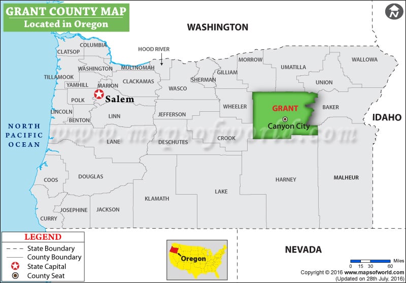
Facts about Grant County
| County | Grant |
| State | Oregon |
| Country | USA |
| Population – 2015 | 7,185 |
More Maps of Grant County
- Grant County Map, Wisconsin
- Grant County Map, South Dakota
- Grant County Map, North Dakota
- Grant County Map, Nebraska
- Grant County Map, Washington
Founded on February 24, 1909, Grant County is located in central Washington. The county seat is Ephrata and its largest city is Moses Lake. The county is named for US President Ulysses S. Grant. It covers an area of 2,791 square miles. The Grand Coulee Dam in the county is the largest electric power-producing dam in the United States.
The Gorge Amphitheatre, Dry Falls, Moses Lake Museum & Art Center (MAC), Grant County Historical Museum, and Summer Falls State Park are popular destinations in the county. Interstate 90, US 2, SR 17, and SR 28 are major corridors in Grant County. Grant County International Airport (MWH) is used as a major jet training and testing facility. Amtrak’s Empire Builder train makes a stop at Ephrata station.
MOW.DT.12.21.16
List of Counties in Oregon |
|||||
|---|---|---|---|---|---|
| County Name | County Seat/Capital | State | 2010 pop. | Area-km | Area-mi |
| Baker | Baker | Oregon | 16,134 | 7,947 | 3,068 |
| Benton | Corvallis | Oregon | 85,579 | 1,751 | 676 |
| Clackamas | Oregon City | Oregon | 3,75,992 | 4,844 | 1,870 |
| Clatsop | Astoria | Oregon | 37,039 | 2,147 | 829 |
| Columbia | Saint Helens | Oregon | 49,351 | 1,703 | 657 |
| Coos | Coquille | Oregon | 63,043 | 4,134 | 1,596 |
| Crook | Prineville | Oregon | 20,978 | 7,716 | 2,979 |
| Curry | Gold Beach | Oregon | 22,364 | 4,215 | 1,627 |
| Deschutes | Bend | Oregon | 1,57,733 | 7,817 | 3,018 |
| Douglas | Roseburg | Oregon | 1,07,667 | 13,043 | 5,036 |
| Gilliam | Condon | Oregon | 1,871 | 3,120 | 1,205 |
| Grant | Canyon City | Oregon | 7,445 | 11,729 | 4,529 |
| Harney | Burns | Oregon | 7,422 | 26,245 | 10,133 |
| Hood River | Hood River | Oregon | 22,346 | 1,352 | 522 |
| Jackson | Medford | Oregon | 2,03,206 | 7,209 | 2,784 |
| Jefferson | Madras | Oregon | 21,720 | 4,612 | 1,781 |
| Josephine | Grants Pass | Oregon | 82,713 | 4,247 | 1,640 |
| Klamath | Klamath Falls | Oregon | 66,380 | 15,387 | 5,941 |
| Lake | Lakeview | Oregon | 7,895 | 21,080 | 8,139 |
| Lane | Eugene | Oregon | 3,51,715 | 11,793 | 4,553 |
| Lincoln | Newport | Oregon | 46,034 | 2,538 | 980 |
| Linn | Albany | Oregon | 1,16,672 | 5,931 | 2,290 |
| Malheur | Vale | Oregon | 31,313 | 25,609 | 9,888 |
| Marion | Salem | Oregon | 3,15,335 | 3,062 | 1,182 |
| Morrow | Heppner | Oregon | 11,173 | 5,262 | 2,032 |
| Multnomah | Portland | Oregon | 7,35,334 | 1,117 | 431 |
| Polk | Dallas | Oregon | 75,403 | 1,919 | 741 |
| Sherman | Moro | Oregon | 1,765 | 2,133 | 824 |
| Tillamook | Tillamook | Oregon | 25,250 | 2,856 | 1,103 |
| Umatilla | Pendleton | Oregon | 75,889 | 8,328 | 3,216 |
| Union | La Grande | Oregon | 25,748 | 5,275 | 2,037 |
| Wallowa | Enterprise | Oregon | 7,008 | 8,149 | 3,146 |
| Wasco | The Dalles | Oregon | 25,213 | 6,168 | 2,382 |
| Washington | Hillsboro | Oregon | 5,29,710 | 1,876 | 724 |
| Wheeler | Fossil | Oregon | 1,441 | 4,441 | 1,715 |
| Yamhill | McMinnville | Oregon | 99,193 | 1,854 | 716 |

 Wall Maps