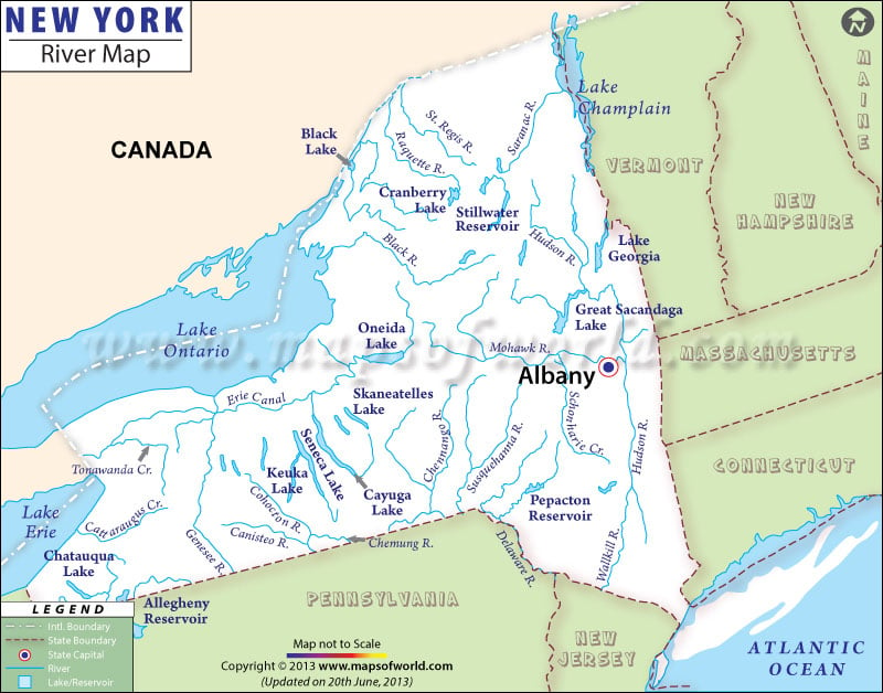
About New York Rivers
The New York rivers map marks the rivers, lakes and streams flowing through the state of New York. The Mohawk, Allegheny, Hudson, and Genesee Rivers are some of the notable rivers of the state.
Hudson River
It originates from Lake Tear of the Clouds and run towards the south across the eastern region of the state without irrigating the Champlain Lake or George Lake. Lake George pours at its north border into Lake Champlain, whose northern boundary stretches into Canada. In the Canadian territory, the river empties into the Richelieu and subsequently the St. Lawrence Rivers.
The Hudson river has a drainage basin of 14,000 sq miles (36,260 km) and has a length of 315 miles. The Mohawk River empties into the Hudson River.
Mohawk River
It is an important river lying in this state. The length of the river is 140 miles (230 km). It is also the biggest tributary of the Hudson River. The Mohawk River runs into the Hudson River in the Capital Territory, one or two miles north to the Albany city. The river got its name from the Mohawk Nation of the Iroquois Union. Mohawk is an important shipping canal in north-central New York.
The Black, Oswego, and Genesee are some of the prominent rivers of the western and central region of New York that drain into Lake Ontario.
Allegheny River
It irrigates the western parts of the state. It penetrates the state from the south in the southeast end of Cattaraugus County, runs in virtually an arc, with its outer bend to the north, and runs beyond the state in the southwestern region of the Cattaraugus County. The river has a number of tributaries in the north and east. Majority of these torrents run in deep gorges edged by vertical, stony hillsides. The length of the river is almost 325 miles and it flows through the states of Pennsylvania and New York.
Lakes in New york
New York rivers map indicates the accurate location of the rivers and natural lakes of the state of NY. The state is home to 6,713 natural lakes, ponds, and reservoirs. The state encompasses 1,745 square miles of total inland water area.
Oneida is the largest lake in New York. Lake Placid, Finger Lake, George Lake, Otsego Lake and Lake Champlain are some of the other prominent lakes in the state.
New York has 9,767 miles of total shoreline, and has 10 fresh water lakes. Lake Champlain of Essex County encompasses a total surface area of 490 square miles. Niagara Falls, beside the Niagara River, flows at an average rate of 1.56 million gallons per second.
Longest Rivers in New York
1. Saint Lawrence River – 744 miles (1,197 km)
2. Susquehanna River – 464 miles (747 km)
3. Allegheny River – 325 miles (523 km)
4. Hudson River – 315 miles (507 km)
5. Delaware River – 301 miles (484 km)
6. Genesee River – 157 miles (253 km)
7. Mohawk River – 149 miles (240 km)
8. Raquette River – 146 miles (235 km)
9. Oswegatchie River – 137 miles (220 km)
10. Black River – 125 miles (201 km)

 Wall Maps