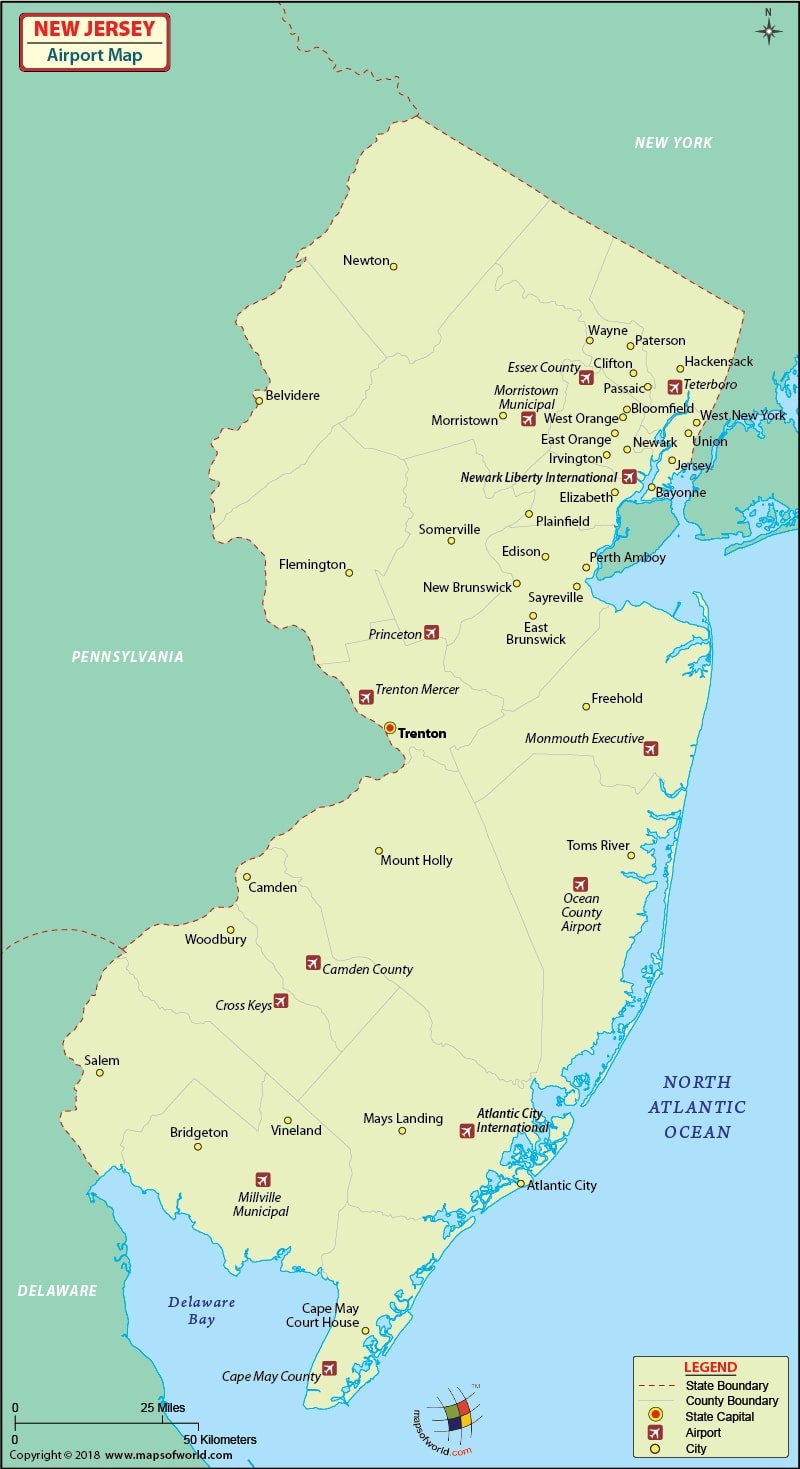
Airports in New Jersey
There are 53 airports in New Jersey, The international airports in New Jersey are, Atlantic City International Airport in Atlantic City and the Newark Liberty International Airport in Newark.
The Atlantic City International Airport in Atlantic City receives more than a million passengers annually. The airport is disability-friendly and gives top priority to customer satisfaction. Therefore, it has a customer service booth. The amenities available at this airport of New Jersey are newspaper and gift shops, snack bars, ATMs, and easy access to car rental agencies within the airport. The airlines that serve this airport are:
Air Canada, Virgin Atlantic, Air France, US Airways Express, Air India, Czech Airlines, Delta Airlines, Midwest, USA 3000, Mexicana, El Al, British Airways, America West, Alaska Airlines, Qantas, Singapore Airlines, TAP Portugal, Jet Blue, Continental Airlines, American Eagle, Air Tran Airways, Comair, Lufthansa, Lot Polish, and SAS.
You can book your airline tickets online with these New Jersey Airports. Some of the airlines offer discounts and special fares for booking their tickets online.
The important airports in New Jersey are in:
Peterson, Newark, Jersey City, Asbury Park, Trenton, Philadelphia, Atlantic City and Cape May.
Here’s a look at the details about some of the most popular airports in New Jersey:
-
Atlantic City International Airport
This is a joint civil-military airport that is situated 10 miles northwest of Atlantic City, New Jersey, in Egg Harbor Township. Accessible via the Exit 9 on the Atlantic City Expressway, the airport has a majority of its land owned by the Federal Aviation Administration and the same is leased to the SJTA (South Jersey Transportation Authority), which owns the terminal building.
-
Princeton Airport
This is a public-use airport in Montgomery Township, Somerset County, New Jersey. It is situated three miles north of Princeton and is privately owned by Princeton Aero Corporation. It houses the Princeton Pilot Shop, Analar Helicopter Charter, Raritan Valley Flying School, Pacific Aircraft and Platinum Helicopters.
-
Lakewood Airport
This is yet another public-use airport which is located about three nautical miles i.e. 6 km southeast of the central business district of Lakewood, in Ocean County, New Jersey. Owned by Lakewood Township, the airport is included in the National Plan of Integrated Airport Systems for the duration 2011-2015.
-
Trinca Airport
Trinca Airport is a public use airport situated in Sussex County, New Jersey. It is owned by Green Township and is situated three nautical miles i.e. 6 km southwest of the central business district of Andover. The airport has a single runway, which is dedicated 6/24 with a turf surface that measures 1,924 by 135 feet.
Maps of Major Airports in New jersey
- Atlantic City International Airport Map
- Princeton Airport Map
- Lakewood Airport Map
- Trinca Airport Map
List of Airports in New Jersey |
|---|
| Airport Name | City | Coordinates |
|---|---|---|
| Atlantic City International Airport | Atlantic City | 39°27′27″N 074°34′38″W |
| Trenton-Mercer Airport | Trenton | 40°16′36″N 074°48′48″W |
| Newark Liberty International Airport | New York metropolitan area | 40°41′33″N 074°10′07″W |
| Morristown Municipal Airport | Morristown | 40°47′58″N 074°24′54″W |
| Teterboro Airport | Teterboro | 40°51′00″N 074°03′39″W |
| Aeroflex-Andover Airport | Andover | 41.00862, -74.738034 |
| Trinca Airport | Andover | 40°57′58″N 074°46′54″W |
| Camden County Airport | Berlin | 39°46′42″N 074°56′52″W |
| Blairstown Airport | Blairstown | 40°58′16″N 074°59′51″W |
| Bucks Airport | Bridgeton | 39°28′23″N 075°11′04″W |
| Cross Keys Airport | Cross Keys | 39°42′20″N 075°01′59″W |
| Hackettstown Airport | Hackettstown | 40°49′18.4″N 074°51′15″W |
| Redwing Airport | Jobstown | 40.026501, -74.692658 |
| Little Ferry Seaplane Base | Little Ferry | 40.842778, -74.03 |
| Flying W Airport | Lumberton | 39.934278, -74.80725 |
| Newton Airport | Newton | 41°01′38″N 074°45′31″W |
| Old Bridge Airport | Old Bridge | 40.329887, -74.346786 |
| Spitfire Aerodrome | Pedricktown | 39°44′08″N 075°23′52″W |
| Alexandria Airport | Pittstown | 40°35′15″N 075°01′09″W |
| Sky Manor Airport | Pittstown | 40°33′59″N 074°58′43″W |
| Red Lion Airport | Vincentown | 39.904152, -74.74955 |
| Kroelinger Airport | Vineland | 39°31′26″N 075°02′47″W |
| Vineland-Downstown Airport | Vineland | 39°32′22″N 074°58′04″W |
| Eagles Nest Airport | West Creek | 39°39′55.4″N 74°18′28.5″W |
| Southern Cross Airport | Williamstown | 39.655556, -75.014444 |

 Wall Maps