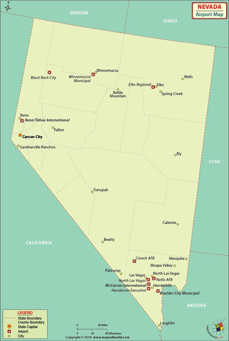
Nevada Airports
There are 54 public-use airports in Nevada. People come to the Silver State from all over the globe, and its airports are well equipped to meet the growing demands of tourism.
The international airports in Nevada are the McCarran International Airport in Las Vegas and the Reno/Tahoe International Airport in Reno.
The McCarran International Airport is a busy airport seeing almost 45 million travelers per year. The airport has many amenities for its customers, such as restaurants, pay phones, assistance for the disabled including free wheelchairs, banking facilities and several news and gift shops, and good parking facilities.
Some of the airlines that serve McCarran are Air Canada, Air Tran, American Airlines, Delta Airlines, Jet Blue Airways, Miami Air, Philippine Airlines, United Airways, Virgin Atlantic, Sky Service Airlines, Omni Air International, Northwest Airlines, Allegiant Air, Air Transat, Aero Mexico, ATA, and Southwest Airlines.
Tickets can be booked online for these airlines, and some offer special fares and discounts through their websites.
The North Las Vegas Airport, which is regional, is the second busiest of all the airports in Nevada. Well built with meeting rooms, conference areas, restaurants, disabled-friendly services, and many shopping and dining areas, the North Las Vegas Airport is used heavily for general aviation.
The primary airports in Nevada are at Winnemucca, Lovelock, Reno, Carson City, Fallon, Hawthorne, Austin, Eureka, Elko, Wells, Battle Mntn, Tonopah, Lathrop Wells and Las Vegas.
Maps of Major Airports in Nevada
List of Airports in Nevada |
|---|
| Airport Name | City | Coordinates |
|---|---|---|
| Boulder City Municipal Airport | Boulder City | 35°56′50″N 114°51′37″W |
| Elko Regional Airport | Elko | 40°49′30″N 115°47′30″W |
| McCarran International Airport | Las Vegas | 36°04′48″N 115°09′08″W |
| Reno/Tahoe International Airport | Reno | 39°29′57″N 119°46′05″W |
| Ely Airport | Ely | 39°17′59″N 114°50′31″W |
| North Las Vegas Airport | Las Vegas / North Las Vegas | 36°12′38″N 115°11′40″W |
| Kidwell Airport | Cal-Nev-Ari | 35°18′20″N 114°52′58″W |
| Parker Carson Airport | Carson City | 39°12′06″N 119°41′00″W |
| Dyer Airport | Dyer | 37°36′35″N 118°00′23″W |
| Empire Airport | Empire | 40°34′43″N 119°21′05″W |
| Tiger Field | Fernley | 39°33′35″N 119°14′29″W |
| Lida Junction Airport | Goldfield | 37°29′31″N 117°11′18″W |
| Kingston Airport | Kingston | 39°12′11″N 117°03′52″W |
| Mina Airport | Mina | 38°22′47″N 118°05′47″W |
| Echo Bay Airport | Overton | 36°18′40″N 114°27′50″W |
| Spanish Springs Airport | Reno / Spanish Springs | 39°39′59″N 119°43′24″W |
| Sky Ranch Airport | Sandy Valley | 35°47′35″N 115°37′35″W |
| Searchlight Airport | Searchlight | 35°26′40″N 114°54′34″W |
| Rosaschi Air Park | Smith | 38°50′22″N 119°20′18″W |

 Wall Maps