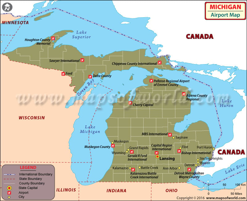
Michigan is a large state and well connected to both global destinations and the rest of USA. Because of this Michigan airports typically experience a high volume of travelers each day. There are 236 airports in Michigan that the public can use and many private ones. Most of the Airports have a lot of traffic and as a result have state-of-the-art technology and friendly service to provide a comfortable flying experience for their customers.
There are many international airports in Michigan, including the Bishop International Airport at Flint, the Gerald R. Ford International Airport at Grand Rapids, the Kalamazoo/ Battle Creek International Airport at Kalamazoo, the Sawyer International Airport at Marquette, the MBS International Airport at Saginaw and the Chippewa County International Airport at Sault Ste. Marie. Apart from these are there are also general aviation international airports such as the Coleman A. Young Airport at Detroit, the Oakland County International Airport at Pontiac, St. Clair County International Airport and the Merillat International Airport.
Maps of Major Airports in Michigan
- Bishop International Airport Map
- Gerald R. Ford International Airport Map
- Sawyer International Airport Map
- Chippewa County International Airport Map
- Oakland County International Airport Map
- St. Clair County International Airport Map
- MBS International Airport Map
List of Airports in Michigan |
|---|
| Airport Name | Airport Code | City | Coordinates |
|---|---|---|---|
| Alpena County Regional Airport | APN | Alpena | 45°04′41″N 083°33′37″W |
| Charlevoix Municipal Airport | CVX | Charlevoix | 45°18′17″N 085°16′31″W |
| Detroit Metropolitan Wayne County Airport | DTW | Detroit / Romulus | 42°12′45″N 083°21′12″W |
| Delta County Airport | ESC | Escanaba | 45°43′22″N 087°05′37″W |
| Bishop International Airport | FNT | Flint | 42°57′56″N 83°44′37″W |
| Gerald R. Ford International Airport | GRR | Grand Rapids | 42°52′51″N 85°31′22″W |
| Houghton County Memorial Airport | CMX | Hancock / Calumet | 47°10′06″N 088°29′21″W |
| Ford Airport | IMT | Iron Mountain / Kingsford | 45°49′06″N 088°06′52″W |
| Kalamazoo/Battle Creek International Airport | AZO | Kalamazoo / Battle Creek | 42°14′06″N 85°33′07″W |
| Capital Region International Airport | LAN | Lansing | 42°46′43.1″N 84°35′10.3″W |
| Sawyer International Airport | MQT | Marquette / Gwinn | 46°21′13″N 087°23′43″W |
| Muskegon County Airport | MKG | Muskegon | 43°10′04″N 086°14′08″W |
| Pellston Regional Airport | PLN | Pellston | 45°34′15″N 84°47′48″W |
| MBS International Airport | MBS | Saginaw | 43°31′58″N 084°04′47″W |
| Chippewa County International Airport | CIU | Sault Ste. Marie | 46°15′03″N 084°28′21″W |
| Cherry Capital Airport | TVC | Traverse City | 44°44′30″N 085°34′56″W |
| Welke Airport | — | Beaver Island | 45°43′16″N 085°31′13″W |
| Manistee County Blacker Airport | MBL | Manistee | 44°16′21″N 086°14′49″W |
| Oakland County International Airport | PTK | Detroit/Pontiac | 42°39′56″N 083°25′13″W |
| Baraga Airport | — | Baraga | 46°47′05.70″N 088°34′40.20″W |
| University Airpark | — | Bath | 42°50′25.120″N 84°28′44.92″W |
| Belleville Airport | — | Belleville | 42°10′36.15″N 83°32′44.77″W |
| Betz Airport | — | Blissfield | 41°51′20.17″N 83°52′14.78″W |
| Brighton Airport | — | Brighton | 42°34′11″N 083°46′43″W |
| Shamrock Field | — | Brooklyn | 42°05′42.15″N 84°14′26.81″W |
| Buzzwick Airport | — | Carleton | 42°01′05″N 083°22′38″W |
| Wend Valley Airport | — | Charlotte | 42°34′45.131″N 84°54′29.97″W |

 Wall Maps