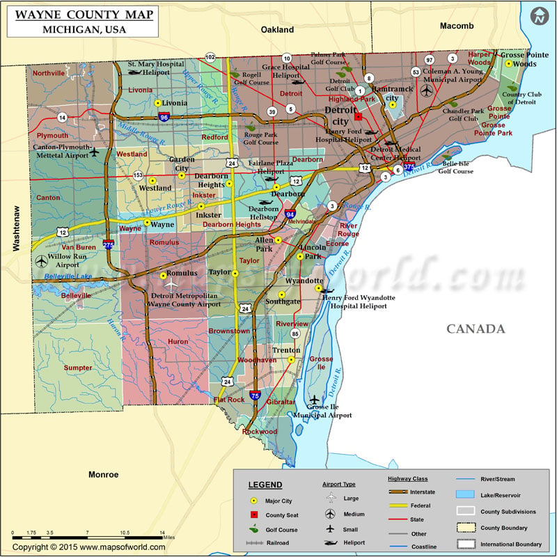
Airports in Wayne County Airport Name A T I Heliport Bob Walberg Field Canton-Plymouth-Mettetal Airport Cobo Hall Heliport Coleman A. Young Municipal Airport Cottonwood Airport Dearborn Helistop Detroit Medical Center…
Airports in Wayne County
Airport Name
A T I Heliport
Bob Walberg Field
Canton-Plymouth-Mettetal Airport
Cobo Hall Heliport
Coleman A. Young Municipal Airport
Cottonwood Airport
Dearborn Helistop
Detroit Medical Center Heliport
Detroit Metropolitan Wayne County Airport
Executive Heliport
Grace Hospital Heliport
Grosse Ile Municipal Airport
Henry Ford Hospital Heliport
Henry Ford Wyandotte Hospital Heliport
L & L Heliport
St. Mary Hospital Heliport
Wdiv-Tv Channel 4 Heliport
Willow Run Airport
More Maps of Wayne County
Cities in Wayne County
City
Population
Latitude
Longitude
Allen Park city
28210
42.259678
-83.210633
Belleville city
3991
42.202183
-83.483944
Dearborn city
98153
42.312688
-83.212937
Dearborn Heights city
57774
42.316407
-83.276857
Detroit city
713777
42.383414
-83.102408
Ecorse city
9512
42.249022
-83.13977
Flat Rock city
9878
42.099178
-83.271583
Garden City city
27692
42.324387
-83.341212
Gibraltar city
4656
42.095998
-83.202867
Grosse Pointe Park city
11555
42.372856
-82.922755
Grosse Pointe Woods city
16135
42.436604
-82.898884
Hamtramck city
22423
42.395387
-83.055951
Harper Woods city
14236
42.438983
-82.929385
Highland Park city
11776
42.405228
-83.097648
Inkster city
25369
42.293484
-83.314825
Lincoln Park city
38144
42.243298
-83.181007
Livonia city
96942
42.397159
-83.373307
Melvindale city
10715
42.280237
-83.178096
Northville city
5970
42.435444
-83.488999
Plymouth city
9132
42.371807
-83.467979
River Rouge city
7903
42.273096
-83.124556
Riverview city
12486
42.172849
-83.19352
Rockwood city
3289
42.07065
-83.242913
Romulus city
23989
42.223693
-83.365978
Southgate city
30047
42.204702
-83.205775
Taylor city
63131
42.226052
-83.268811
Trenton city
18853
42.139402
-83.193041
Wayne city
17593
42.277448
-83.387719
Westland city
84094
42.319222
-83.380546
Woodhaven city
12875
42.132013
-83.237375
Wyandotte city
25883
42.211293
-83.155888

 Wall Maps