Colorado Physical Map
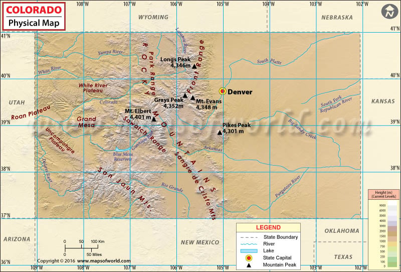
The geography of the state of Colorado includes both rugged mountainous terrain, endless plains, desert lands, arid canyons, and mesas. From west to east, the rectangle-shaped state features desert basins and desert canyons turning into desert plateaus, then alpine mountains, and eventually into the grasslands of the High Plains. Colorado is the only state in the United States that lies entirely above 1000 meters in elevation. The Rocky Mountains in Colorado encompass 54 peaks that are 14,000 feet (4270 m) or higher.
At 14,440 feet (4,401.2 m), the summit of Mount Elbert is the highest point in Colorado and the highest point in the Rockies of North America. The mountainous terrain is timbered with conifers at an elevation of 12,000 feet (3,650 m) in southern Colorado to 10,500 feet (3,200 m) in northern Colorado. To the east of the Rockies in Colorado are the High Plains, a sub-region of the Great Plains within Colorado. These plains have elevations ranging between 3,500 and 7,000 feet (1,100 to 2,100 meters).
To the west lies the eastern slope of the Rockies with notable summits such as Longs Peak, Mount Evans, Pikes Peak, and the Spanish Peaks. The Continental Divide extends along the crest of the Rockies. To the west of the Divide is the Western Slope, which covers 38% of Colorado’s area. Water west of the Divide drains towards the west via the Colorado River into the Pacific Ocean. Western Colorado is composed of mountains, mesas, canyons, and desert lands.
The state also features some high broad basins. In the north, east of the Continental Divide is North Park which is drained by the North Platte River. Just south of the North Park lies Middle Park which is drained by the Colorado River and its tributaries. Further to the south, lies the San Luis Valley which is the headwaters of the Rio Grande. These basins lie along the Rio Grande Rift, a major tectonic feature.

 Wall Maps