
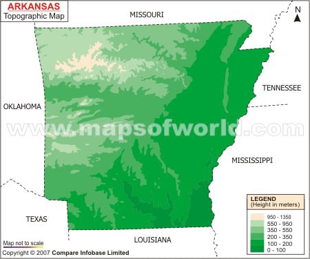
The Ouachita and Boston mountains form the prime upper lands of Arkansas state. The low lands of Arkansas are categorized into Gulf Coastal Plain and Mississippi Alluvial Plains. Known by the name of Ozark Plateau Boston mountains occupy the northwestern front of Arkansas along with parts of Oklahoma, Missouri and Illinois. The topography map of Arkansas highlights Magazine mountain which has an elevation point of 2,753 ft. Lakes and ridges are a significant element of the topography of Arkansas. The 29 km long Chicot lake which is at the southeastern part of Arkansas is the largest natural stream of the place. Whereas Ouachita lake occupying a total area of 163 sq km is the largest artificial lake of Arkansas state. Rivers are also a major part of the Arkansas topography. The Arkansas river valley is one of the prime Topographic traits of Arkansas state which paves the way for Ouachita mountains. River Ouachita is the lowest Topographic zone of Arkansas with 55 ft and lies in the south-central part of the state.
Arkansas Topographic Map
Arkansas Topographic Map shows the land forms, rivers, hills, low mountains and plateaus that surround the state from all directions. Also, the Arkansas state map provides detailed information regarding the entire topography of the place.
Find the Topographic map of Arkansas.