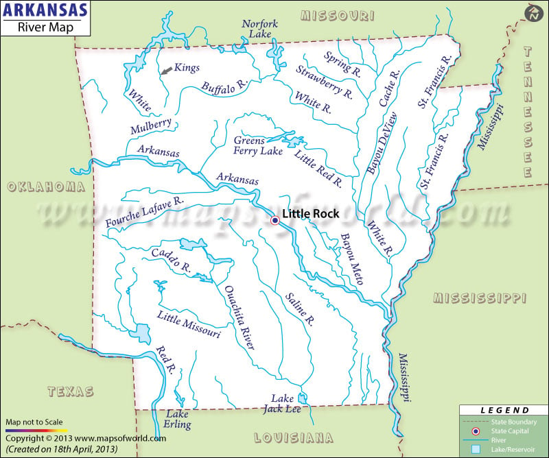
What are the major rivers in Arkansas?
The Arkansas Rivers Map indicates the natural streams that flows through many prominent cities of the state. The 1,450-mile long Arkansas River is known as the major perennial resource of the state. The river pass through northeastern Oklahoma, Kansas, Arkansas and Colorado and finally converges with the Mississippi River. The prime tributaries of the Arkansas River are Big Piney Creek, Mulberry and Petit Jean Rivers, Bayou Foursche LaFave, Cadron Creek, Bayou Metro, Lee Creek, Fall Creek, Shoal Creek, Illinois Bayou Middle Fork, Frog Bayou, Cub Creek, Illinois Bayou North Fork and Hurricane Creek. The map also highlights the other major streams of the state apart from the Arkansas. Some prominent waterways that pass through Arkansas are Kings River, Buffalo River, Little Missouri River, Eleven Point River, White River, Little Red River, Cossatot River, Ouachita River, Caddo River, Spring River, Saline River and the Strawberry River. The state map focuses on important drains and rivers to provide a clear idea about the natural streams. Apart from the natural splendor, the rivers also offer several tourism options like rafting, boating and fishing.
Rivers in Arkansas |
|---|
| S.no. | River Name | Area / Length | Source | Mouth |
|---|---|---|---|---|
| 1 | Kings River | 82.5 miles | ( Boston Mountains) Madison County, Arkansas | White River in Table Rock Lake, Barry County, Missouri |
| 2 | Buffalo River | 240 km | Boston Mountains | Salem Plateau just before joining the White River |
| 3 | White River | 722 mi (1,162 km) | Boston Mountains | Mississippi River |
| 4 | Mulberry River | 110 km (70 mi) | Ozarks, Newton County, Arkansas | Arkansas River |
| 5 | Arkansas River | 1,469 mi (2,364 km) | Confluence of East Fork Arkansas River and Tennessee Creek | Mississippi River |
| 6 | Green Ferry Lake | NA | NA | NA |
| 7 | Little Red River | 102-mile-long (164 km) | Devils Fork, Middle Fork, South Fork ( Greers Ferry Dam in Cleburne County, Arkansas) | Confluence with the White River in White County, Arkansas |
| 8 | Strawberry River | 115 mi (185 km) | Fulton County, Arkansas | Black River |
| 9 | Spring River | 92 km (57 mi) | Mammoth Spring State Park, Howell County, Missouri | Eleven Point River |
| 10 | Cache River | 213 mi (343 km) | White River in Monroe County, Arkansas | Greene County, Arkansas |
| 11 | Bayou Deview River | 83-mile-long (134 km) | Craighead County, Arkansas | Cache River in Monroe County, Arkansas |
| 12 | St. Francis River | 426 mi (686 km) | Elephant Rocks State Park | Mississippi River |
| 13 | Fourche Lafave River | 140 mi (225 km) | Scott County, Arkansas | Bigelow, Arkansas |
| 14 | Bayou Meto | 150 mi (240 km) | Wilson Hill, Faulkner (Origin) | Arkansas River |
| 15 | Caddo River | 82 mi (132 km) | Caddo Mountains | Ouachita River |
| 16 | Saline River | 325 km (202 mi) | Ouachita Mountains | Ouachita River |
| 17 | Ouachita River | 605 mi (974 km) | Ouachita Mountains, Polk County, Arkansas (Location) | Black River |
| 18 | Little Missouri | 147-mile-long (237 km) | Mountains of Polk County, Arkansas | Ouachita River in Ouachita County, Arkansas |
| 19 | Red River | NA | NA | NA |
| 20 | Lake Erling | NA | NA | NA |
| 21 | Lake Jack Lee | NA | NA | NA |
| 22 | Mississippi River | 2,320 mi (3,734 km) | Lake Itasca | Gulf of Mexico |

 Wall Maps