For centuries, Tahoma—one of many names given to the mountain by native tribes—represented a mighty source of power. Centuries on, many believe that Mount Rainier National Park owes its status in large part to the citizens of Seattle and Tacoma, who recognized the majesty of the area. Mount Rainier and its surrounding forests were designated Mount Rainier Forest Reserve in 1893; six years later it was designated a national park. The park hosts an array of terrain, including vast fields of flower parklands. Beyond the meadows are more than 300 lakes, dozens of waterfalls, 25 glaciers, and 50 permanent snowfields.
How to Visit
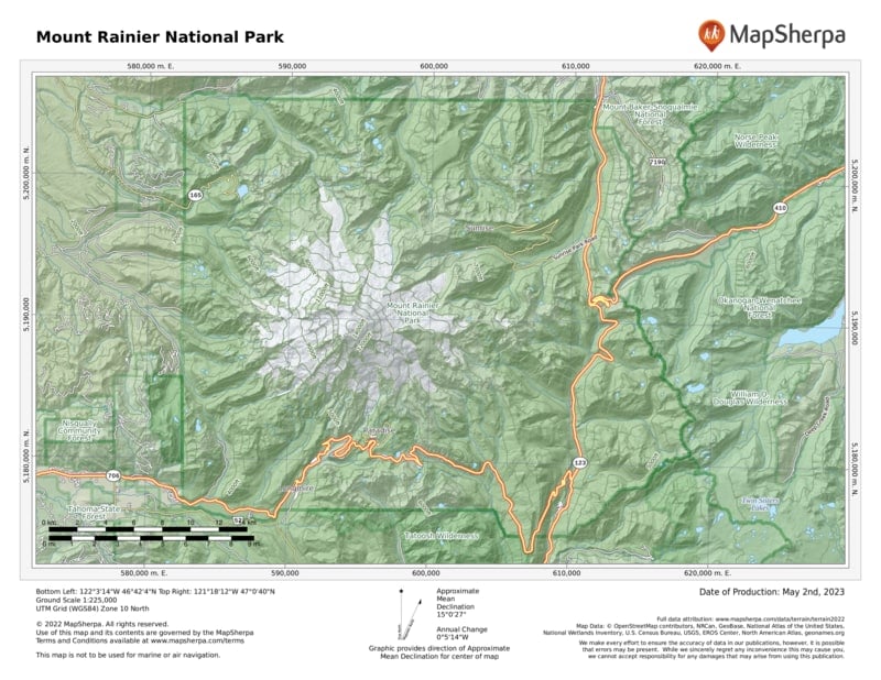
For a summer visit, travelers can see the best of the park in a day provided they get an early start. Begin at the White River Entrance and follow the road to its end, Sunrise Visitor Center. From here, on a clear day, the northeastern face of Mount Rainier sparkles in the first light of day. From Sunrise, head south to the Stevens Canyon Entrance to explore some more. In late afternoon, head to the heavenly meadows of Paradise. Linger here into the evening for the chance to catch the peak bathed in the amber light known as alpenglow. With more time, head to the park’s northwest corner far off the beaten path.
If planning a winter visit, the Paradise area, on Mount Rainier’s southern flank, offers some of the best and most accessible snow recreation in the Pacific Northwest. The National Park Service keeps the road from Longmire to Paradise plowed and open year-round, conditions permitting; the road is closed at night. Most other roads open late June or early July and close by mid-November.
Because the snowpack typically tops 20 feet or more, snowshoers and cross-country skiers are free to ramble anywhere they’d like in the Paradise area. Check the weather and avalanche conditions prior to heading out.
When snow levels drop midwinter, snowshoers also find great options in the Longmire area. The Trail of the Shadows and the section of the Wonderland Trail from Longmire east along the Nisqually River are two easy snowshoe routes.
Useful Information
How to get there
For a summer visit, travelers can see the best of the park in a day provided they get an early start. Begin at the White River Entrance and follow the road to its end, Sunrise Visitor Center. From here, on a clear day, the northeastern face of Mount Rainier sparkles in the first light of day. From Sunrise, head south to the Stevens Canyon Entrance to explore some more. In late afternoon, head to the heavenly meadows of Paradise. Linger here into the evening for the chance to catch the peak bathed in the amber light known as alpenglow. With more time, head to the park’s northwest corner far off the beaten path.
If planning a winter visit, the Paradise area, on Mount Rainier’s southern flank, offers some of the best and most accessible snow recreation in the Pacific Northwest. The National Park Service keeps the road from Longmire to Paradise plowed and open year-round, conditions permitting; the road is closed at night. Most other roads open late June or early July and close by mid-November.
Because the snowpack typically tops 20 feet or more, snowshoers and cross-country skiers are free to ramble anywhere they’d like in the Paradise area. Check the weather and avalanche conditions prior to heading out.
When snow levels drop midwinter, snowshoers also find great options in the Longmire area. The Trail of the Shadows and the section of the Wonderland Trail from Longmire east along the Nisqually River are two easy snowshoe routes.
From Seattle (95 miles northwest), travel via I–5, Wash. 512, and Wash. 7 to the Road of Paradise. From Packwood (10 miles south), take Wash. 123 and Stevens Canyon Road to the Ohanapecosh Entrance. Check the park website or MountRainierNPS on Twitter for current conditions and road status.
When to go
The Nisqually Entrance to Paradise is open year-round. Most other roads open late June or July and close by midNov. Wildflowers in the Paradise and Sunrise areas peak in early Aug., as do the crowds. Backcountry trails are snowclogged until mid-July. Mid-Sept. typically has good weather and less crowds.
Visitor Centers & Museum
Longmire Museum is open year-round; Henry M. Jackson Memorial Visitor Center, open May–late Oct. and weekends the rest of the year; Ohanapecosh Visitor Center and Sunrise Visitor Center, generally open July to mid-Sept.
Headquarters
55210 238 Ave. E. Ashford, WA 98304 nps.gov/mora 360-569-22111
Camping
Two of the park’s four campgrounds, Cougar Rock and Ohanapecosh, allow reservations during peak season and generally fill up. White River Campground is first come, first served. The Forest Service maintains campgrounds near Mount Rainier at La Wis Wis, The Dalles, and American River. NPS and USFS sites may be reserved at recreation.gov (626 sites). Backpackers need backcountry camping permits. For information, 360-569-4453.
Lodging
The facilities in the park, National Park Inn (25 rooms) and Paradise Inn (open May through Oct., 121 rooms), are operated by Mount Rainier Guest Services (mtrainierguestservices.com). For lodging in neighboring communities: visitrainier.com.
US National Parks Map
About the Guide


