For more than 20 years, Jim White pushed farther into the cave, constantly trying to publicize this underground wonderland in remote southeastern New Mexico.
In 1924, he personally guided a special National Geographic Society expedition into the caverns. The resulting report in the magazine used language a bit more formal to express a superlative judgment: “For spacious chambers, for variety and beauty of multitudinous natural decorations, and for general scenic quality, it is king of its kind.”
King, indeed: Carlsbad is one of the most famous caves in the world, and the various languages heard on a walk through its passages testify to its wide-ranging appeal.
The story behind the cave’s spectacular sights begins around 265 million years ago, when sea creatures formed a 400-mile-long U-shaped limestone reef along the shores of a broad bay. After the ocean receded, the reef was buried beneath sedimentary material. Over the past 15 to 20 million years, tectonic forces lifted, and erosion exposed, part of it as the Guadalupe Mountains, under which Carlsbad Cavern lies.
About 6 million years ago, the chambers were formed, not from underground streams as is the case for most caves, but from the dissolving power of naturally created sulfuric acid. Still later, water seeping into the cave and evaporating left behind the minerals that make up the stalactites, stalagmites, and other speleothems (the name for cave formations).
More than 119 other caves are known within the national park boundary, including Lechuguilla Cave, the deepest limestone cave in the United States. Discovered in 1986, this cave is so pristine and scientifically important that it’s open only to researchers.
There’s plenty to see aboveground in Carlsbad Caverns National Park, too. The Chihuahuan Desert is the largest and wettest of the North American deserts. The park is one of the few places where a substantial area of this unique ecosystem is protected. Most of the park is an officially designated Wilderness, with hiking trails crisscrossing the backcountry.
How to Visit
Begin at the park visitor center, which is where you buy tickets for admittance into the caverns. Ride the elevator down into the cave, and take the self-guided Big Room tour. This 1.25-mile, relatively flat walk passes many of the cave’s most famous formations, and there’s a shortcut that cuts the route’s length almost in half.
If you’re in good shape, you can consider traveling to the Big Room by walking the extremely steep, 1.25-mile route through the Natural Entrance—the equivalent of walking up (or down) a 75-story building.
Plan ahead and reserve a spot on the 1.5-hour ranger-led tour of King Palace, which passes through rooms known for their formations.
With an additional day or more, check out other ranger-led tours within Carlsbad Caverns or Slaughter Canyon Cave. You can also enjoy the 9.5-mile Walnut Canyon Desert Drive, a scenic loop through the Chihuahuan Desert. And from early spring through October, don’t miss the evening bat flight (see p. 168).
Information
How to get there
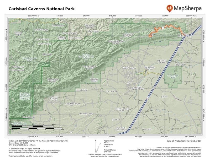
To access the park’s only entrance road, N. Mex. 7, turn north from U.S. 62/180 at Whites City, which is 20 miles southeast of Carlsbad and 145 miles northeast of El Paso, TX.
When to go
The temperature in the cave remains about 56°F year-round. In summer (late May through early Sept.) entrance hours are extended later in the afternoon.
Visitor Center
The park visitor center is located 7 miles west of Whites City, NM, on N. Mex. 7. Open year-round.
Headquarters
3225 National Parks Hwy. Carlsbad, NM 88220 nps.gov/cave 575-785-2232
Camping
There is no developed campground in the park. Backcountry camping requires a same-day free permit, available at the visitor center. Commercial campgrounds can be found in Whites City, NM, and Carlsbad, NM.
Lodging
There is no lodging in the park. Hotels are located in Whites City, NM, and Carlsbad, NM. Carlsbad Chamber of Commerce (carlsbad.org, 760-931-8400).
US National Parks Map
About the Guide


