US Interstate 39 highway Map
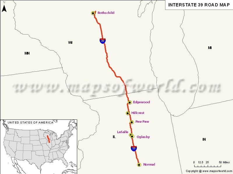
Interstate 39, popularly abbreviated as I-39 is a US highway in the Midwestern United States. It was specially designed to replace the US Highway 51, which in the early 1980s was considered as one of the busiest two-lane highways in the United States. Interstate 39 was built in the 1980s and 1990s. In Illinois, the Interstate 39 has a total length of 140.82 miles i.e. 226.63 Km. Also, in Wisconsin, the highway has a distance of 182 miles i.e. 293 km.
Extent of I-39 Highway
Interstate 39 stretches from Normal, Illinois at Interstate 55 to Wisconsin Highway 20 situated in Rub Mountain, Wisconsin, which is approximately six miles i.e. 9.7 km southwest of Wausau. By December 1987, the construction on section of Interstate 30 between Interstate 80 and IL 251 was complete.States and cities along I-39 Highway
- Texas: Corpus Christi, San Antonio
Restaurants along Interstate-39 Highway
Here is a list of few great restaurants along Interstate-39 Highway:
- Avanti’s Italian Restaurant
- China Star
- Maggie Miley
- Windy City’s Wiener’s
- The Rock Restaurant
Attractions along I-39 Highway
Some of the renowned tourist attractions along I-39 Highway include:
- Ibc Association Hall of Fame
- Eyestone One-Room Schoolhouse
- Dickinson House
- Lock 16 Center
- Lil’s Acres
Route of Interstate Highway No.39 |
| State | Entry Point | Exit Point | Length |
|---|---|---|---|
| Illinois | Normal, IL | Illinois-Wisconsin state line | |
| Wisconsin | Town of Turtle, WI | Rothschild, WI | |
| Total Length | 306.14 mi (492.68 km) |
Last Updated Date: April 15, 2017


