What are the Key Facts of Mississippi?

|
State |
Mississippi |
|
State Capital |
Jackson |
|
Largest City |
Jackson |
|
Coordinates |
33°N 90°W |
|
Nickname(s) |
“The Magnolia State”, “The Hospitality State” |
|
Postal Abbreviation |
MS |
|
Area |
48,430 sq. mi (125,443 sq. km) |
|
Highest Point |
Woodall Mountain, 807 ft (246.0 m) |
|
Number of Counties |
82 |
|
Neighboring States |
Tennessee, Alabama, Arkansas, Louisiana |
|
Population |
2,986,530 (2018) |
|
Date of Entering the Union |
December 10, 1817 |
|
State Anthem |
Go, Mississippi |
|
Governor |
Tate Reeves (Republican) |
|
Lieutenant Governor |
Delbert Hosemann (Republican) |
|
U.S. Senators |
Roger Wicker (Republican), Cindy Hyde-Smith (Republican) |
|
U.S. House Delegation |
Trent Kelly (Republican), Bennie Thompson (Democratic Party), Michael Guest (Republican), Steven Palazzo (Republican) |
|
GDP (Millions of Dollars) |
114834 |
|
Demonym |
Mississippian |
|
Time Zones |
UTC-06:00 (Central), Summer (DST) UTC-05:00 (CDT) |
Where is Mississippi?
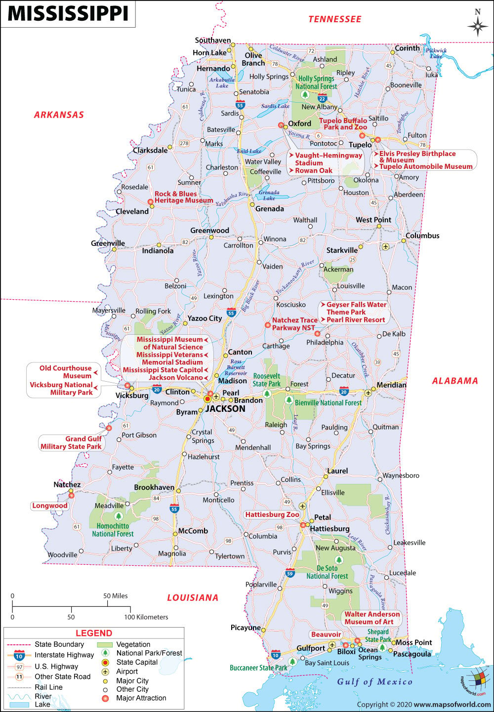
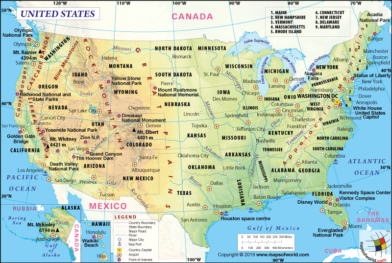
Mississippi (the 20th state admitted to the union on December 10, 1817) is located in the southeast part of the USA. It shares its border with Arkansas to the northeast, Louisiana to the southwest, Alabama to the east, Tennessee to the north, and the Gulf of Mexico to the south. The Mississippi River mainly defines the western boundary.
What is the Geography of Mississippi?
Mississippi is spread across a total area of 48,430 sq. mi (125,443 sq. km), making it the 32nd largest state out of the total 50 states of the US. Out of the total area, the land area is spread across 46,952 sq. mi (121,607 sq. km), and the water area is around 1,521 sq. mi (3,940 sq. km). The state is 340 mi (547.2 km) long and 170 mi (273.6 km) wide.
Mississippi’s mean elevation is 300 ft (91.4 m) above sea level. The Woodall Mountain is the highest elevation point of the state at 806 ft (245.7 m) above sea level. The Gulf of Mexico at sea level (at 0 ft or 0 m) is the lowest elevation point.
The significant mountains of Mississippi are Woodall Mountain, Lebanon Mountain, Tippah Hills, Crum Mountain, Wicker Mountain, Kitchen Mountain, Barnett Knob, Bonds Mountain, Geeville Mountain, and Hamer Hill.
The water bodies occupy 3.1% of the total area in Mississippi. Some of the major rivers in the state are Mississippi River, Tennessee River, Pearl River, Big Black River, Hatchie River, Chickasawhay River, Tombigbee River, Yazoo River, Leaf River, and Yalobusha River. The major lakes in Mississippi are Pickwick Lake, Grenada Lake, Ross Barnett Reservoir, Sardis Lake, Enid Lake, Arkabutla Lake, and Aliceville Lake.
The landform consists of low fertile land between the Mississippi River and Yazoo River. A yellowish-brown loamy deposit called loess is found around the delta border. This deposit is followed by sandy Gulf coastal terraces, prairie, and piney woods. In the northeast as well as Pontotoc Ridge (a black prairie belt), high or sandy hills are situated. Flatlands turn to central highlands as you move from the north towards the center of the land.
What is the Climate of Mississippi?
A humid subtropical climate prevails in Mississippi. It is characterized by temperate winters as well as long and hot summers. Rainfall takes place evenly across the year. Harsh conditions due to the rains are more common. It will either be flood or drought.
The months from May-to-September may be uncomfortable because the southerly winds provide moisture for high humidity. Around 60 days, locally violent and destructive thunderstorms take place. Tornadoes generally take place during springtime. Since 1895, the state’s coastal areas have been hit by eight hurricanes.
The average annual temperature in the north (62 °F or 16.7 °C) varies from that of the coastal area (68 °F or 20 °C). For around 100 days on average every year, the low-temperature drops to -16 °F (-26.7 °C) and high temperatures exceed 90 °F (32.2 °C). Every year, the temperature exceeds 100 °F or 37.8 °C at many places in Mississippi.
Once in 5-years on average, the temperature drops to zero or below. During winter season every year, the temperature becomes freezing in the Gulf Coast. While the north receives an average precipitation level of 50 inches (1,270 mm), the south gets 65 inches (1,651 mm) of precipitation. Almost the entire state (around 95%) receives measurable snowfall or sleet fall every year.
The winters don’t get severe cold. However, summers get extreme heat. Freeing of ground rarely takes place, and outdoor activities can be planned every year. Cold spells generally occur for a short period of time and Mississippi usually gets a long duration of the growing season. The state receives plenty of rainfall, dry spells, and sunshine.
What is the Economy of Mississippi?
The economy of Mississippi is dependent mostly on agriculture and forestry. More than half of the farm-raised catfish is produced in this state. It is also the top producer of pulpwood, cotton, and sweet potatoes. Poultry, aquaculture, livestock, and soybean production also play an important economic role.
Other important industries of the state are advanced manufacturing, health services, education, utilities, transportation, trade (both wholesale and retail), health and social services, real estate, etc. Government (federal, state, and local) manufacturing and services play an essential role in the economy.
The total Gross Domestic Product (GDP) for Mississippi has increased steadily from US$96,843.6 million in 2008 to US$114,834.2 million. The Per Capita, Personal Income of the state, has grown steadily from US$30,479 to US$37,834 during 2008-2018.
The Median Household Income has witnessed regular ups and downs in the last ten years. It was US$36,446 in 2008 but increased sharply to US$41,090 in 2011. However, it nosedived to US$32,338 in 2013. From that level, it recovered steadily to US$43,281 in 2017 and decreased slightly to US$42,781 in 2018.
The total value of exports and imports in 2018 were US$11,630,242,991 and US$16,670,835,668 respectively, resulting in a trade balance of -US$5,040,592,677. In terms of export, import, and trade balance, Mississippi’s rank among the 50 states is 30, 28, and 25, respectively.
The principal exports of Mississippi are Oil and Mineral Fuels, Precision Instruments, Electrical Machinery, Industrial Machinery, Paints and Dyes, Motor Vehicles and Parts, Cotton, Wood Pulp, Plastics, and Iron and Steel. The major import items are Electrical Machinery, Oil and Mineral Fuels, Industrial Machinery, Motor Vehicles and Parts, Precision Instruments, Furniture, Iron and Steel, Knit and Non-Knit Apparel, and Pharmaceuticals.
The rate of unemployment was 5.8% in January 2008. However, it almost doubled in the next 2-years to 10.9% in February 2010. After that, it came down steadily to 4.7% in July 2018. Since then, it has increased slightly to 5.6% in November 2019. In 2018, Mississippi had one of the highest poverty rates among the states of the United States. The total number of people below the poverty line was 571,219 out of a total population of 2,889,851, which means the poverty rate was 19.8%.
What is the Transportation System of Mississippi?
Mississippi’s elaborate transportation system includes roadways, airways, railways, and waterways. There are nine interstate highways and 14 US Routes that pass through the state. While the primary interstate highways are I-10, I-20, I-22, I-55, I-59, and I-69, the auxiliary interstate highways are I-110, I-220, and I-269. The most important US highways are US 11, US 45, US 49, US 51, US 61, US 72, US 78, US 278, US 80, US 82, US 84, US 90, US 98, and US 425. There is also a huge network of state highways across the state, and the Mississippi Department of Transportation maintains them.
The major airports in Mississippi are Jackson–Evers International Airport (in Jackson), Gulfport–Biloxi International Airport (in Gulfport / Biloxi), Golden Triangle Regional Airport (in Columbus), Meridian Regional Airport (in Meridian), Hattiesburg–Laurel Regional Airport (in Hattiesburg / Laurel), Tupelo Regional Airport (in Tupelo), Mid Delta Regional Airport (in Greenville), Tunica Municipal Airport (in Tunica), etc.
Two scheduled passenger train services, provided by Amtrak, are present in the City of New Orleans and Crescent. Rail routes providing freight services in the state are Canadian National Railway’s Illinois Central Railroad, BNSF Railway’s northwest-southeast rail track facility across northern Mississippi, Kansas City Southern Railway, Norfolk Southern Railway, and CSX line along the Gulf Coast.
Waterway facilities are available on some of the major rivers such as Mississippi River, Big Black River, Pascagoula River, Pearl River, Tennessee-Tombigbee Waterway, and Yazoo Rivers.
Why Mississippi is called the “Magnolia State”?
The official nickname of Mississippi is the “Magnolia State”. It got this nickname in honor of the Magnolia Trees, found in abundance in the state. Magnolia is the state’s official flower and tree. “The Magnolia State” has featured in the Mississippi Quarter, issued in October 2002.
Other nicknames of the state are “The Bayou State”, “The Eagle State”, “The Border-eagle State”, “The Mud-cat State”, “The Mud-waddler State”, “The Ground-hog State”, etc.
What are the Popular Tourist Attractions in Mississippi?
Gulf Islands National Seashore, Tupelo Automobile Museum, USS Cairo Museum at Vicksburg National Military Park, B.B. King Museum and Delta Interpretive Center, The Institute for Marine Mammal Studies, Beauvoir, Mississippi Museum of Natural Science, Elvis Presley Birthplace & Museum, Rock & Blues Heritage Museum, Natchez Trace Parkway, Old Courthouse Museum, Old Capitol Museum, Ocean Springs, Mississippi Petrified Forest, Vicksburg National Cemetery
Facts About Mississippi
1) The nicknames of Mississippi are “The Hospitality State” and “The Magnolia State”.
2) Before achieving statehood, it was named as Mississippi Territory. The state was admitted to the Union on December 10, 1817 as the 20th state of the country.
3) In 1870, Mississippi was readmitted to the Union. In 1861, the state had seceded to join the Confederacy following the Civil War.
4) The capital of Mississippi is Jackson. It is also the largest city in the state.
5) The state shares its borders with Alabama, Tennessee, Arkansas, Gulf of Mexico, Mississippi River, and Louisiana.
6) Belzoni is nicknamed as the Catfish Capital of the World.
7) In 1963, the first human lung transplant in the world was performed at the University of Mississippi Medical Center. This medical center is also famous for conducting the first cardiac transplant operation.
8) The Mississippi River is the longest river in the United States. It is also called the Old Man River.
9) The official motto is “By valor and arms”.
10) The official tree is the Magnolia. The scientific name is Magnolia Grandiflora.
11) The official anthem of the state is “Go, Mississippi”. It was written and composed by Houston Davis.
12) The state houses 29 state parks that are prime tourist attractions. Some of the popular parks include Natchez National Historical Park, Jackson Zoological Park, and Vicksburg National Military Park.
13) Jackson, Gulfport, and Biloxi are the three biggest cities in the state.
14) In the beginning, Mississippi was a French settlement and it served as a division of Louisiana. The British Army overpowered the French and subsequently, the area was taken over by the Spanish settlers. It was relinquished to the U.S. in 1783.
15) The official bird is the Mockingbird.
16) The official animal is the Red Fox.
17) The state insect is the Honeybee.
18) The tallest point in the state is the Woodall Mountain and its elevation is 806 feet.
19) The official fish is the Black Bass or Largemouth Bass.
20) The state mammal is the White-Tailed Deer and butterfly is the Spicebush Swallowtail
21) Famous residents of the state of Mississippi include John Grisham, James Earl Jones, Elvis Presley, and Oprah Winfrey.
Related Link:


![]()
