What are the Key Facts of Alaska?

| State | Alaska |
| State Capital | Juneau |
| Largest City | Anchorage |
| Coordinates | 64°N 150°W |
| Nickname(s) | The Last Frontier, Land of the Midnight Sun, Seward’s Icebox |
| Postal Abbreviation | AK |
| Area | 663,268 sq. mi (1,717,856 sq. km) |
| Highest Point | Denali, 20,310 ft (6,190.5 m) |
| Neighboring States | NA (not a part of contiguous US) |
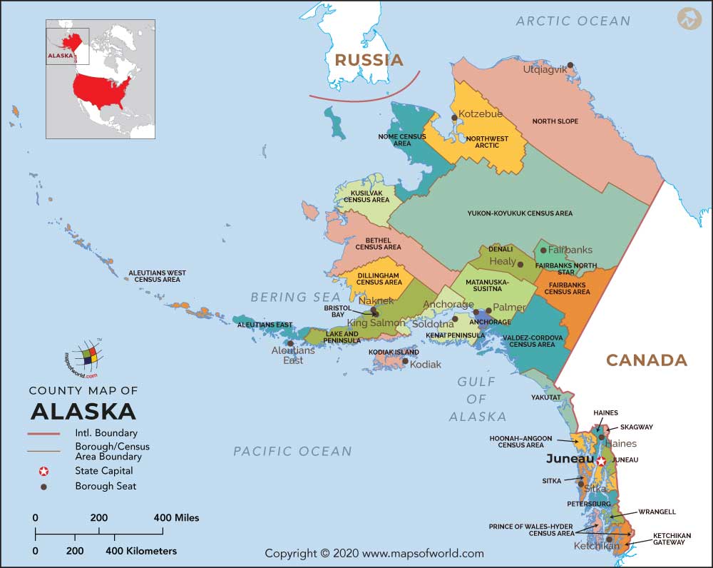
| Number of Counties/ County equivalent | 19 Boroughs, 10 Census Areas |
| Population | 710,249 (2018) |
| Date of Entering the Union | January 3, 1959 |
| State Anthem | Alaska’s Flag |
| Governor | Mike Dunleavy (Republican) |
| Lieutenant Governor | Kevin Meyer (Republican) |
| U.S. Senators | Lisa Murkowski (Republican), Dan Sullivan (Republican) |
| U.S. House Delegation | 1 (Don Young (Republican)) |
| GDP (Millions of Dollars) | 54734 |
| Demonym | Alaskan |
| Time Zones | UTC-09:00 (Alaska) Summer (DST):UTC-08:00 (ADT), UTC-10:00 (Hawaii-Aleutian) Summer (DST): UTC-09:00 (HADT) |
Where is Alaska?
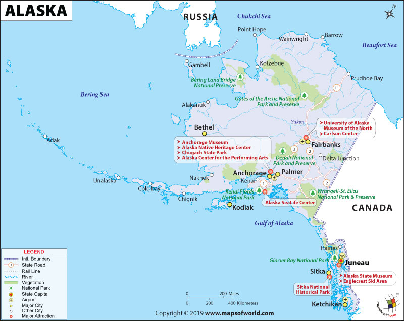
Alaska is located in the extreme northwest of the US West Coast or Pacific Coast, just across Asia’s Bering Strait. While Canada’s British Columbia province is located to the east, the territory of Yukon is situated to the southeast. Attu Island is the farthest western part of the state. Chukchi and Beaufort seas (Arctic Ocean’s southern parts) are to the north of this state. The Pacific Ocean is located to the south and southwest direction of this state.
What is the Geography of Alaska?
Alaska is spread across a total area of 665,384 sq. mi (1,723,337 sq. km), out of which 570,641 sq. mi (1,477,953 sq. km) is land area and 94,743 sq. mi (245,383 sq. km) is water area. Over 14.2% of the total area is composed of water areas. In terms of the area, Alaska is the largest state in the United States and also the 7th largest sub-national division in the world. Around 34,000 miles (55,000 km) of tidal shoreline is present in this state. It doesn’t share its border with another state.
There are six main regions here. They are South Central Alaska (southern coastal region), Southeast Alaska (includes tidewater glaciers and extensive forests), Alaska Interior (characterized by large braided rivers), Southwest Alaska (coastal area bordered by both the Bering Sea and the Pacific Ocean), North Slope (mostly covered by tundra), and Aleutian Islands (includes 14 large volcanic islands and 55 smaller islands).
Some of the principal mountains in this state are Denali, Mount Bona, Mount Foraker, Mount Saint Elias, Mount Blackburn, etc. Major rivers are Yukon River, Kuskokwim River, Porcupine River, and Tanana River.
What is the Climate of Alaska?
There are two types of climatic conditions found in Alaska: the mid-latitude oceanic climate in the south and subarctic oceanic climate in the north. The climatic conditions change drastically as per region and season.
May-to-September is the summer season in this state. May is the driest month of the year, even in the Inside Passage’s temperate rainforest. The average daytime temperature revolves around 70 °F (21 °C) in July and can sometimes also reach 90 °F (32 °C). Generally, the temperature in coastal areas, as well as higher elevations, hardly goes above 65 °F (18 °C). The temperature starts cooling throughout this state during August-September. Cold winter season begins in October and continues till March. While the south-central part gets snow blankets, the temperature in the coastal regions rarely falls below 20 °F (-7 °C) and it remains more or less temperate.
During winter, the temperature can reach below -20 °F (-29 °C), and snow can be seen as early as October. During spring and fall, the days remain warm and nights get cold.
What is the Economy of Alaska?
The total Gross Domestic Product for this state was US$54,734.1 million in 2018, a significant increase from US$49,585.9 million in 2009. This state had a positive balance of trade amounting to US$2,936,911,371, thanks to the total export value of US$4,840,480,086 and total import value of US$1,903,568,715.
The major items exported by this state are seafood, ores, oil and mineral fuels, animal feeds, wood, aircraft, industrial/electrical machinery, etc. The items imported by the state are oil and mineral fuels, industrial/electrical machinery, ores, iron and steel articles, precision instruments, aircraft, motor vehicles and parts, organic chemicals, etc.
Alaska Department of Labor and Workforce Development’s November 15, 2019 press release shows that the seasonally adjusted unemployment rate was 6.2% in October 2019. Over 10.9% of the population in Alaska lived in poverty in 2018.
What is the Transportation System of Alaska?
Alaska has a comparatively fewer transportation system than the other states and union territories of the USA. The main roadway out of this state to Canada is the Alaska Highway. Other main highways are Dalton Highway, Denali Highway, Glenn Highway, Haines Highway, Parks Highway, Richardson Highway (north and south segments), Seward Highway, Steese Highway and Sterling Highway (south and north segments). Alaska has a highly developed airway system, and the most important airports are Ted Stevens Anchorage International Airport, Fairbanks International Airport and Juneau International Airport. Alaska Railroad starts from Seward and continues till the North Pole. Alaska Marine Highway serves the cities in the Alaska Peninsula, Southcentral Alaska, and Southeast Alaska.
Why is Alaska called the “The Last Frontier”, “Land of the Midnight Sun”, “Seward’s Folly”, or “Seward’s Ice Box”?
The Last Frontier
Alaska got its nickname “The Last Frontier” because of its vast distance away from the other 48 states of the USA to its south. The immense rugged landscape and brutal climate of the 49th state to the union, its vast size (1,420 miles or 2,285 km from north to south and 2,500 miles or 4,023 km from east to west), significant isolation, and mostly unexplored areas are the reasons why this state is called “The Last Frontier”.
Land of the Midnight Sun
Alaska is also called the “Land of the Midnight Sun” because the sun doesn’t completely go below the horizon during summer. Even at midnight, the sun remains visible. In certain parts of this state, daylight remains for round the clock (24-hours). The sun doesn’t set in Barrow for as long as 84 days in a year.
Seward’s Folly or Seward’s Ice Box
US Secretary of State William H. Seward negotiated and convinced the US Congress to release the US$7.2 million fund for buying the Alaska territory, and signed the treaty with Russia for the purchase of Alaska. When he was convincing the US Congress for the final Congressional approval for the purchase, there was a long-drawn, bitter battle for the approval of money.
On March 30, 1867, an agreement was reached, and on October 18, 1867, the Imperial Russian Flag was lowered in Sitka, and the United States’ Stars and Stripes were raised. The final payment of US$7,200,000 was made in the form of a check (issued on August 1, 1868), payable to the then Russian Minister to the USA, Edouard de Stoeckl.
The critics of Seward’s agreement has called it by various satirical and derisive names such as “Seward’s Folly”, “Seward’s Ice Box”, “Icebergia”, “Walrussia”, “Polaria” and even “Johnson’s Polar Bear Garden” (mocking the then US President Andrew Johnson’s decision of giving the go-ahead). That’s how Alaska is also called “Seward’s Folly” and “Seward’s Ice Box”.
What are the Popular Tourist Attractions in Alaska?
Denali National Park, Glacier Bay National Park, Gates of the Arctic National Park, Katmai National Park, Kobuk Valley National Park, Lake Clark National Park, Wrangell-St. Elias National Park, Kenai Fjords National Park, Tracy Arm Fjord, Prince William Sound, Alaska Highway, University of Alaska Museum of the North, Mendenhall Glacier, Chugach National Forest, Anchorage Museum at Rasmuson Center, Alaska SeaLife Center, Sitka National Historic Park/Totem Park, Alaska Inside Passage, Klondike Gold Rush National Historical Park, Dalton Highway, Alaska Native Heritage Center, Iditarod National Historic Trail, Seward, Alaska Railroad, etc.
Facts About Alaska
Alaska is the biggest state in the United States. It attained statehood on January 3, 1959 and is the 49th state of the country. The capital of the state is Juneau and the largest city is Anchorage. The demonym of Alaska is Alaskan. The state covers an area of 663,268 sq miles. Know interesting Alaska facts and trivia to enrich your knowledge.
1) In 1741, foreigners first found Alaska when Vitus Jonassen Bering, a voyager from Denmark saw it on a journey from Siberia.
2) In 1784, whale hunters from Russia and fur dealers on Kodiak Island set up the oldest colony in Alaska.
3) William H. Seward, the then United States Secretary of State in 1867, made a bid of $7,200,000 or 2 cents per acre to Russia for purchasing Alaska.
4) Alaska formally turned into the land of the U.S. on October 18, 1867. Most of the U.S. citizens term the acquisition “Seward’s Folly”.
5) The finding of gold by Joe Juneau in 1880 was a precursor of the gold rush period.
6) The Aleutian Islands were raided by Japan in 1943, which initiated the One Thousand Mile War, the first conflict which took place on U.S. territory after the Civil War.
7) On January 3, 1959, Alaska was formally declared as the 49th state of the U.S.
8) The most significant source of income in Alaska is the oil and natural gas sector.
9) Alaska represents nearly 1/4th of the oil production in the U.S.
10) Alaska is so big that the state of Rhode Island can be incorporated into the state 425 times.
11) Prudhoe Bay is the biggest oil field in the Northern United States. It is situated on the northern shores of Alaska.
12) The Trans-Alaska Pipeline is capable of carrying 88,000 barrels of oil/hour to Valdez throughout a distance of 800 miles.
13) The seafood and angling business is the biggest private sector employer in the state.
14) Majority of crab, salmon, herring, and halibut of the United States are fished from Alaska.
15) The expression Alaska native denotes the initial occupiers of Alaska such as Eskimo, Aleut, and Indian communities.
16) The official state flower is the wild forget-me-not. It was approved by the Territorial Legislature in 1917.
17) The official state bird is the Willow Ptarmigan. It was accepted by the Territorial Legislature in 1955.
18) The official state tree is the Sitka spruce. It was acknowledged by the Territorial Legislature in 1962.
19) The official state sport is Dog Mushing. It was approved by the Alaska Legislature in 1972.
20) In 1910, an unidentified designer made the state seal. It comprises a rising sun shining on jungles, lagoon, shipping and angling vessels, and mining and farming operations.
21) The state slogan is North to the Future.
22) The official state gemstone is the jade.
23) The official state mineral is gold. Gold was chosen as the state mineral in 1968.
24) The official state insect is the four-spot skimmer dragonfly.
25) Bennie Benson, a 13-year-old from Cognac, Alaska planned the state flag in 1926.
26) Alaska is nicknamed America’s Last Frontier.
27) After every four years, the residents of Alaska choose a Governor and a Lieutenant Governor by ballots who continue for a term of four years.
28) The Alaska State Legislature consists of a House of Representatives and Senate.
29) Twenty senators are chosen for a term of four years and forty diplomats are elected for a term of two years.
30) Alaska’s Constitution was sanctioned in 1956 and came into existence in 1959, when it became the 49th state of the U.S.
31) Almost 33% of Alaska is situated inside the Arctic Circle.
32) In the beginning, the Alaska Highway was constructed as an army provision way during the Second World War.
33) The state features the lowest density of population in the country.
34) In 1898, the unearthing of gold in the Yukon region started a gold rush. Subsequently, gold was found at Fairbanks and Nome.
35) Alaska is an environmental wonder. If a scale map of the state is put on top of a map of the 48 lower states, the state stretches from shore to shore.
36) The shoreline of the state stretches for more than 6,600 miles.
37) Alaska is the biggest state in the U.S. and is more than two times the area of Texas (View Alaska Map). If gauged from north to south, the length of the state is around 1,400 miles and if it is gauged from east to west, the breadth of the state is 2,700 miles.
38) Attu, Agattu, and Kiska are the only regions in the Northern United States that were captured by Japanese forces during the Second World War.
39) The most precious natural resource of the state is oil. It is home to what is known as the biggest oil field in Northern U.S.
40) There was a volcanic eruption in Mount Augustine in 1986, which was close to Anchorage.
41) The geographical core of Alaska is located 60 miles northwest of Mount McKinley.
42) The biggest national forest in the U.S. is the Tongass National Forest.
43) 17 of the 20 tallest summits in the U.S. are situated in Alaska.
44) Mt. McKinley is the tallest peak in North America with an elevation of 20,320 feet above sea level. It lies in the center of Alaska.
45) The biggest city in the state is Anchorage and the second biggest is Fairbanks.
46) The biggest mountain range in the state is the Alaska Range. It stretches from the Cape of Alaska to the Yukon Province.
47) The highest temperature of 100˚ Fahrenheit was recorded in Alaska at Fort Yukon in 1915. In 1971, the lowest temperature of -80˚ Fahrenheit was recorded at Prospect Creek Camp.
48) The malamute sled dog in Alaska is physically powerful and deeply furred. It was raised as a variety by an Eskimo community known as the Malemiuts.
49) The name Alaska originated from the Eskimo term Alakshak, which stands for cape or vast territories.
50) The official state song is “Alaska’s Flag”.
Related Links:


![]()
