logo


Yuba County Map

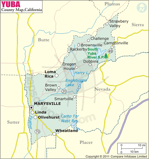
Below is the County Map of Yuba in California showing the boundaries, roads, highways, towns and much more.

Map of Yuba County, California
Yuba County Map
Description:Map of Yuba county showing the major towns, highways and much more. Disclaimer
×

Disclaimer  :  All efforts have been made to make this image accurate. However MapSherpa, Inc, its directors and employees do not own any responsibility for the correctness or authenticity of the same.


Inside the page

Facts about Yuba County

County NameYuba County
FoundedFeb 18, 1850
Area1,670 km2 (644 sq mi)
Land Area1,640 km2 (632 sq mi)
Water Area30 km2 (12 sq mi)
Population72,155 (2010)
CitiesMarysville, Wheatland
County SeatMarysville
Time zonePacific Standard Time (UTC-8)Summer (DST) Pacific Daylight Time (UTC-7)

Cities and Towns in Yuba County


CityPopulation
Beale AFB1,319
Camptonville158
Challenge-Brownsville1,148
Dobbins624
Linda17,773
Loma Rica2,368
Marysville city12,072
Olivehurst13,656
Plumas Lake5,853
Smartsville177
Wheatland city3,456


Mountain Peaks in Yuba County


Mountain Peak/HillElevation [Meter]
Barton Hill1176
Big Hill1145
Buzzard Peak386
Cape Horn837
Chaparral Hill651
Clark Hill712
Daugherty Hill543
Dixon Hill702
Donovan Hill495
Flanly Peak636
Fountain House Hill982
Galena Hill892
Hansonville Hill797
High Prairie581
Holman Hill282
Howard Hill252
Johnson Peak238
Lafferty Peak267
Lamb Hill633
McCartie Hill127
McGinn Hill378
Meade Hill308
Mount Hope1075
Oregon Peak1047
Paynes Peak342
Pike County Peak1095
Pittsburgh Hill1144
Ray Hill326
Red Bluff766
Red Hill420
Rose Hill324
Ruff Hill906
Scott Hill616
Stanfield Hill515
Sugarloaf451
Summit Hill960
Texas Hill579
Ure Mountain672
Walsh Hill380
Youngs Hill854


Airports in Yuba County


Airport Name
Beale Air Force Base
Brownsville Airport
Double Tree Farm Airport
Old Aerodrome
Yuba County Airport

Golf Courses in Yuba County


Name of Golf CourseLatitudeLongitude
Coyote Run Golf Course-Beale Afb39.113278-121.348829
Peach Tree Golf & Country Club-Marysville39.136441-121.545818
Plumas Lake Golf & Country Club-Olivehurst39.033557-121.561124

County Maps of California

Alameda County MapMarin County MapSan Luis Obispo County Map
Alpine County MapMariposa County MapSan Mateo County Map
Amador County MapMendocino County MapSanta Barbara County Map
Butte County MapMerced County MapSanta Clara County Map
Calaveras County MapModoc County MapSanta Cruz County Map
Colusa County MapMono County MapShasta County Map
Contra Costa County MapMonterey County MapSierra County Map
Del Norte County MapNapa County MapSiskiyou County Map
El Doredo County MapNevada County MapSolano County Map
Fresno County MapOrange County MapSonoma County Map
Glenn County MapPlacer County MapStanislaus County Map
Humboldt County MapPlumas County MapSutter County Map
Imperial County MapRiverside County MapTehama County Map
Inyo County MapSacramento County MapTrinity County Map
Kern County MapSan Benito County MapTulare County Map
Kings County MapSan Bernardino County MapTuolumne County Map
Lake County MapSan Diego County MapVentura County Map
Lassen County MapSan Francisco County MapYolo County Map
Los Angeles County MapSan Joaquin County MapYuba County Map
Madera County Map 


Map of Cities in California

Long Beach city MapOakland city MapAnaheim city Map
Santa Ana city MapRiverside city MapStockton city Map
Chula Vista city MapFremont city MapIrvine city Map
San Bernardino city MapModesto city MapOxnard city Map
Los Angeles city Map San Francisco city Map Sacramento city Map
San Jose city Map Bakersfield city Map Fullerton city Map


Last Updated Date: October 27th, 2016