logo


Yolo County Map

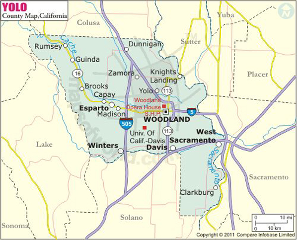
Below is the County Map of Yolo in California showing the boundaries, roads, highways, towns and much more.
Yolo County Map
Description:Map of Yolo county showing the major towns, highways and much more. Disclaimer
×

Disclaimer  :  All efforts have been made to make this image accurate. However MapSherpa, Inc, its directors and employees do not own any responsibility for the correctness or authenticity of the same.


Yolo County in California


Yolo County is located in the Sacramento Valley, a sub-region of Central Valley in Northern California. The county seat is Woodland. Davis is the most populous city and West Sacramento – the area west of the Sacramento River – is the largest settlement by area. The county spans an area of 1,024 square miles. Known as the center of California's tomato industry, the county features relatively more rural agricultural communities.


The Gibson Mansion, the U.S. Bicycling Hall of Fame, Bohart Museum of Entomology, I Street Bridge, Old Sugar Mill in Clarksburg, and UC Davis Botanical Conservatory are significant places to visit in Yolo County. Whole Earth Festival, Davis Transmedia Art Walk, and Picnic Day at UC Davis are major events in the city of Davis. Woodland hosts the Yolo County Fair every August.

Interstate 5, I-80, SR 16, SR 45, and SR 84 are major corridors in Yolo County. Yolobus provides local public transportation in the county. Amtrak station in Davis is served by Amtrak's California Zephyr, Capitol Corridor, and Coast Starlight routes.

MOW.DT.01.04.17


Inside the page

Facts about Yolo County

County NameYolo County
FoundedFeb 18, 1850
Area1,024 sq mi (2,650 km2)
Land Area1,015 sq mi (2,630 km2)
Water Area8.9 sq mi (23 km2)
Population200,849 (2010)
Largest cityDavis (population) West Sacramento (area)
CitiesWoodland, Davis, West Sacramento, Winters
County SeatWoodland
Time zonePacific Standard Time (UTC-8) Summer (DST) Pacific Daylight Time (UTC-7)

Cities in Yolo County


CityPopulation
  • Clarksburg
  • 418
  • Davis city
  • 65,622
  • Dunnigan
  • 1,416
  • Esparto
  • 3,108
  • Guinda
  • 254
  • Knights Landing
  • 995
  • Monument Hills
  • 1,542
  • University of California Davis
  • 5,786
  • West Sacramento city
  • 48,744
  • Winters city
  • 6,624
  • Woodland city
  • 55,468
  • Yolo
  • 450


    Mountain Peaks in Yolo County


    Mountain Peak/HillElevation [Meter]
    Bald Mountain552
    Berryessa Peak927
    Black Mountain717
    Canterbury Mountain743
    China Peak344
    Edgar Peak682
    Glascock Mountain733
    Langs Peak809
    Monument Hill48
    Sugarloaf213
    The Trees808
    Twin Sisters770
    Tyndall Mound10
    Wild Cow Mountain685

    Airports in Yolo County


    Airport Name
    Borges - Clarksburg Airport
    Chp Academy Airport
    G3 Ranch Airport
    Joe Heidrick Heliport
    Lake Berryessa Seaplane Base
    Medlock Field
    University Airport
    Watts Woodland Airport
    Yolo County Davis Woodland Winters Airport


    Golf Courses in Yolo County


    Name of Golf CourseLatitudeLongitude
    Campers Inn Golf Course-Dunnigan38.902841-121.98954
    Davis Municipal Golf Course-Davis38.583766-121.772126
    El Macero Country Club-El Macero38.543795-121.68417
    Mountain Valley Golf Center-Woodland38.659353-121.72852
    Wild Wings Golf Club-Woodland38.673738-121.883552
    Wildhorse Golf Course-Davis38.568652-121.721623
    Yolo Fliers Club-Woodland38.677864-121.868734


    Map of Cities in California

    Long Beach city MapOakland city MapAnaheim city Map
    Santa Ana city MapRiverside city MapStockton city Map
    Chula Vista city MapFremont city MapIrvine city Map
    San Bernardino city MapModesto city MapOxnard city Map
    Los Angeles city Map San Francisco city Map Sacramento city Map
    San Jose city Map Bakersfield city Map Fullerton city Map


    Last Updated Date: January 06th, 2017