Inside the page
Facts about Tuolumne County
County NameTuolumne County
FoundedFeb 18, 1850
Area5,890 km2 (2,274 sq mi)
Land Area5,750 km2 (2,221 sq mi)
Water Area140 km2 (54 sq mi)
Population55,365 (2010)
County SeatSonora
Time zonePacific Standard Time (UTC-8)Summer (DST) Pacific Daylight Time (UTC-7)
About Tuolumne County, California
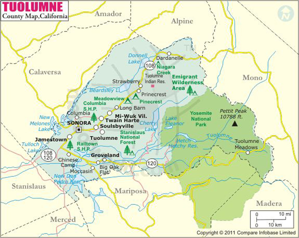
Spanning an area of 2,274 square miles, Tuolumne County is located in the Sierra Nevada's Gold Country region in Northern California. The seat and only incorporated city of the county is Sonora. The northern portion of Yosemite National Park spills into the eastern Tuolumne County. Mother Nature's most exalted grandeur, Yosemite Valley is like a vast edifice of stone and space.
sublime wonderlands
The pristine, scenic expanse of the county in the Sierra Nevada foothills lies about two and half hours east of the San Francisco Bay Area. The Stanislaus National Forest, Yosemite National Park and other wilderness areas offer natural vistas and activities including hiking, skiing, horseback riding, fishing, rafting, snowmobiling, and boating. Scores of endless adventures await in this land of purple mountain majesty. Gold Rush-era towns & saloons, wineries, and historical museums make the county a year-round destination.
Pine Mountain Lake, Mono Vista, Jamestown, and Columbia are picturesque census-designated places in Tuolumne County. Railtown 1897 State Historic Park, Table Mountain, Hetch Hetchy, and Yosemite Valley are notable attractions in the county. State Highways 108 and 120 enter from San Francisco and East Bay Area, while SR 49 comes in from the north. The State Route 120 allows direct access to Yosemite National Park. Airports in Pine Mountain Lake and Columbia are used mostly for general aviation.
MOW.DT.01.14.17
Mountain Peaks in Tuolumne County
Mountain Peak/Hill | Elevation [Meter] |
Acker Peak | 3,310 |
Ackerson Mountain | 1,588 |
Amelia Earhart Peak | 3,648 |
Andrews Peak | 2,602 |
Ascension Mountain | 1,600 |
Bald Mountain | 2,208 |
Bald Mountain | 1,016 |
Bald Mountain | 1,771 |
Bald Peak | 2,954 |
Bartlett Peak | 2,531 |
Bath Mountain | 3,195 |
Bear Mountain | 1,610 |
Bell Hill | 708 |
Bell Mountain | 2,425 |
Ben Brow Hill | 324 |
Bigelow Peak | 3,213 |
Black Hawk Mountain | 3,138 |
Blank Peak | 322 |
Blewetts Point | 977 |
Bourland Mountain | 2,346 |
Buckhorn Mountain | 1,005 |
Bull Run Rock | 2,393 |
Burst Rock | 2,781 |
Camiaca Peak | 3,574 |
Castle Rock | 2,857 |
Cathedral Peak | 3,308 |
Chittenden Peak | 2,920 |
Colby Mountain | 2,938 |
Cold Mountain | 3,138 |
Cone Hill | 807 |
Cooper Peak | 2,913 |
Craig Peak | 3,362 |
Crandall Peak | 1,664 |
Doghead Peak | 3,338 |
Dome Rock | 2,235 |
Domingo Peak | 756 |
Double Dome Rock | 2,401 |
Double Rock | 2,958 |
Duckwall Mountain | 1,775 |
Eagle Peak | 2,856 |
Elbow Hill | 2,827 |
Elizabeth Peak | 1,486 |
Excelsior Mountain | 3,791 |
Fairview Dome | 2,958 |
Finger Peaks | 3,422 |
Forsyth Peak | 3,299 |
Gillett Mountain | 2,527 |
Grand Mountain | 2,877 |
Granite Dome | 3,149 |
Grapevine Point | 1,108 |
Grey Butte | 3,452 |
Hammils Mountain | 318 |
Haystack Peak | 3,044 |
Hells Mountain | 2,115 |
Hetch Hetchy Dome | 1,882 |
Hog Mountain | 756 |
Hooper Peak | 2,902 |
Hungry Hill | 463 |
Hunter Point | 1,077 |
Jenkins Hill | 362 |
Joes Point | 1,281 |
Johnson Peak | 3,369 |
Jones Hill | 947 |
Kendrick Peak | 3,145 |
Kennebec Hill | 721 |
Kennedy Peak | 3,234 |
Keyes Peak | 3,231 |
Kolana Rock | 1,760 |
Le Conte Point | 1,936 |
Leavitt Peak | 3,516 |
Lembert Dome | 2,871 |
Liberty Hill | 2,302 |
Lucky Point | 358 |
Mahan Peak | 2,735 |
Mammoth Peak | 3,685 |
Marble Mountain | 1,665 |
Matterhorn Peak | 3,653 |
McKee Hill | 1,942 |
Mercur Peak | 2,428 |
Michie Peak | 3,126 |
Moccasin Peak | 894 |
Molo Mountain | 3,302 |
Mount Conness | 3,825 |
Mount Dana | 3,976 |
Mount Eaton | 951 |
Mount Gibbs | 3,893 |
Mount Gibson | 2,547 |
Mount Knight | 1,459 |
Mount Lewis | 1,661 |
Mount Maclure | 3,869 |
Mount Provo | 1,480 |
Murphy Peak | 1,365 |
Nance Peak | 2,578 |
Negro Hill | 807 |
Night Cap Peak | 3,209 |
North Mountain | 1,747 |
Page Mountain | 641 |
Penole Peak | 290 |
Peoria Mountain | 544 |
Pettit Peak | 3,277 |
Pikes Peak | 2,205 |
Pinecrest Peak | 2,574 |
Piute Mountain | 3,180 |
Pothole Dome | 2,672 |
Potter Point | 3,253 |
Price Peak | 3,251 |
Puppy Dome | 2,671 |
Quarry Peak | 3,385 |
Quartz Mountain | 502 |
Rafferty Peak | 3,382 |
Ragged Peak | 3,312 |
Rancheria Mountain | 2,732 |
Red Peak | 3,050 |
Regulation Peak | 3,222 |
Relief Peak | 3,261 |
Repeater Hill | 1,672 |
Richardson Peak | 3,002 |
Rushing Mountain | 460 |
Sachse Monument | 2,804 |
Sapps Hill | 2,225 |
Sawmill Mountain | 1,600 |
Schofield Peak | 3,025 |
Sheep Peak | 3,601 |
Shepherd Crest | 3,576 |
Shumake Knoll | 1,799 |
Slide Mountain | 3,168 |
Slide Mountain | 3,375 |
Smith Peak | 2,356 |
Snow Peak | 3,324 |
Stanton Peak | 3,552 |
Strawberry Peak | 1,840 |
Sugarloaf | 1,180 |
Taylor Hill | 509 |
Telegraph Hill | 1,128 |
The Three Chimneys | 2,952 |
Thompson Peak | 1,607 |
Thunder Hill | 1,824 |
Tiltill Mountain | 2,733 |
Tip Top Peak | 1,018 |
Tower Peak | 3,571 |
Tulloch Mountain | 282 |
Tuolumne Peak | 3,309 |
Twin Peaks | 3,718 |
Unicorn Peak | 3,286 |
Union Hill | 659 |
Virginia Peak | 3,646 |
Volunteer Peak | 3,200 |
Wells Peak | 3,366 |
West Peak | 3,207 |
Wet Meadow Hill | 1,206 |
Wheeler Peak | 2,736 |
Whorl Mountain | 3,642 |
Wildcat Point | 2,879 |
Airports in Tuolumne County
Airport Name |
Bald Mountain Heliport |
Columbia Airport |
Columbia Heliport |
Hermitage Airport |
Kistler Ranch Airport |
Peoria Airport |
Pine Mountain Lake Airport |
Cities in Tuolumne County
City | Population | Latitude | Longitude |
Cedar Ridge | 1,132 | 38.066108 | -120.273744 |
Chinese Camp | 126 | 37.870244 | -120.44429 |
Cold Springs | 181 | 38.161335 | -120.053527 |
Columbia | 2,297 | 38.033331 | -120.409654 |
East Sonora | 2,266 | 37.977675 | -120.341104 |
Groveland | 601 | 37.832535 | -120.239375 |
Jamestown | 3,433 | 37.957349 | -120.411076 |
Long Barn | 155 | 38.095685 | -120.128543 |
Mi-Wuk Village | 941 | 38.056976 | -120.178977 |
Mono Vista | 3,127 | 38.012316 | -120.269776 |
Phoenix Lake | 4,269 | 38.007428 | -120.308978 |
Pine Mountain Lake | 2,796 | 37.859874 | -120.184357 |
Sierra Village | 456 | 38.07676 | -120.162348 |
Sonora city | 4,903 | 37.981685 | -120.382303 |
Soulsbyville | 2,215 | 37.991764 | -120.261661 |
Strawberry | 86 | 38.198663 | -120.010525 |
Tuolumne City | 1,779 | 37.961512 | -120.242745 |
Tuttletown | 668 | 38.000344 | -120.450291 |
Twain Harte | 2,226 | 38.038399 | -120.233947 |
Golf Courses in Tuolumne County
Name of Golf Course | Latitude | Longitude |
Mountain Springs Golf Club-Sonora | 37.94653 | -120.360197 |
Phoenix Lake Golf Course-Sonora | 38.011693 | -120.304922 |
Pine Mountain Lake Country Club-Groveland | 37.854372 | -120.221834 |
Twain Harte Golf Club-Twain Harte | 38.039313 | -120.230266 |
National Parks in Tuolumne County
Name of Park | Latitude | Longitude |
Yosemite NP | 37.848203 | -119.556299 |
Last Updated Date: January 17th, 2017