logo


Stanislaus County Map

Below is the County Map of Stanislaus in California showing the boundaries, roads, highways, towns and much more.

Map of Stanislaus County, California
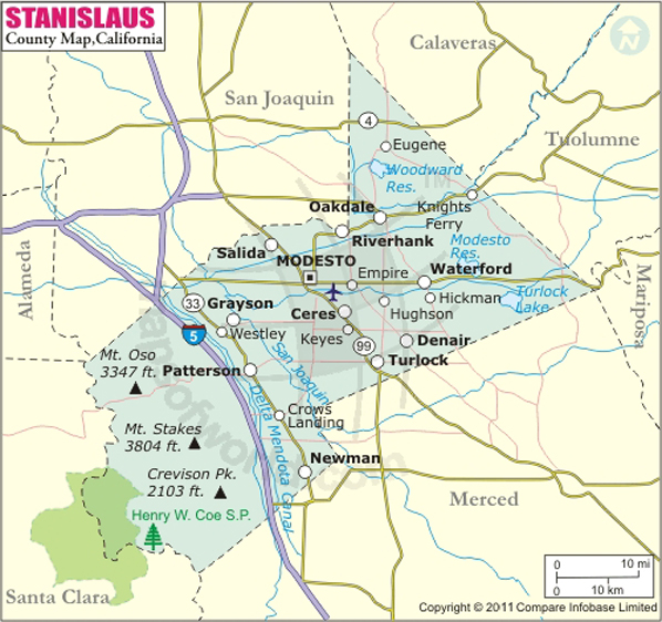
Stanislaus County Map
Description:Stanislaus County Map showing the County boundaries, county seat, major cities, highways, roads, rail network, rivers, airports, etc. Disclaimer
×

Disclaimer  :  All efforts have been made to make this image accurate. However MapSherpa, Inc, its directors and employees do not own any responsibility for the correctness or authenticity of the same.


Inside the page


Stanislaus County in California


Stanislaus County located in the Central Valley of Northern California. Carved out of Tuolumne County in 1854, the county covers a total area of 1,515 square miles. The county seat and the largest city is Modesto since 1871. The Stanislaus River, San Joaquin River, and Tuolumne River are major waterways in the Central Valley.

The San Joaquin River National Wildlife Refuge features woodlands, wetlands, and grasslands which allow ample opportunities for nature viewing. Turlock Lake State Recreation Area is popular for water sports including fishing and camping at Woodward Reservoir Regional Park or Modesto Reservoir is another favorite pastime of county residents. The city of Modesto is 90 miles north of Fresno and 92 miles east of San Francisco. The Strand Theatre, Gallo Center for the Arts, Modesto Centre Plaza, and Gallo Family Winery are prominent attractions in Modesto.


Much of the settlements in the county are either bedroom communities for the Bay area or small farming communities depending on local economy. Turlock, Ceres, Riverbank, and Oakdale are major cities in Stanislaus County. Major highways include Interstate 5, State Route 4, SR 33, and SR 99.

MOW.DT.01.10.17

Facts about Stanislaus County

County NameStanislaus County
Founded1854
Area1,515 sq mi (3,920 km2)
Land Area1,495 sq mi (3,870 km2)
Water Area20 sq mi (50 km2)
Population514,453 (2010)
Largest cityModesto (population and area)
County SeatModesto
Time zonePacific Standard Time (UTC-8) Summer (DST) Pacific Daylight Time (UTC-7)


Cities and Towns in Stanislaus County


CityPopulation (Cencus 2010)
Airport1,964
Bret Harte5,152
Bystrom4,008
Ceres city45,417
Cowan318
Crows Landing355
Del Rio1,270
Denair4,404
Diablo Grande826
East Oakdale2,762
Empire4,189
Grayson952
Hickman641
Hughson city6,640
Keyes5,601
Modesto city201,165
Monterey Park Tract133
Newman city10,224
Oakdale city20,675
Parklawn1,337
Patterson city20,413
Riverbank city22,678
Riverdale Park1,128
Rouse2,005
Salida13,722
Shackelford3,371
Turlock city68,549
Valley Home228
Waterford city8,456
West Modesto5,682
Westley603


Airports in Stanislaus County


Airport Name
Emanuel Medical Center Heliport
First Interstate Bank Operations Center Heliport
Flying Bull Airport
Mapes Ranch Airport
Modesto City Co-Harry Sham Field
Nasa Crows Landing Airport
Oakdale Airport
Patterson Airport
Peterson Airport
Turlock Airpark
Yandell Ranch Airport

Golf Courses in Stanislaus County


Name of Golf CourseLatitudeLongitude
Creekside Golf Course-Modesto37.649294-120.939291
Del Rio Country Club-Modesto37.74264-121.004423
Diablo Grande-Patterson37.401841-121.266733
Dryden Park Golf Course-Modesto37.618025-121.002377
Modesto Municipal Golf Course-Modesto37.627629-120.999344
Oakdale Golf & Country Club-Oakdale37.778151-120.816892
River Oaks Golf Course-Ceres37.609954-120.932103
St Stanislaus Golf Course-Modesto37.565469-120.993491


Mountain Peaks in Stanislaus County


Mountain Peak/HillElevation [Meter]
Black Hill543
Black Hill140
Black Mountain687
Bone Spring Hill764
Copper Mountain807
Crevison Peak626
Crow Hill213
Eli Hill624
Hamner Hill717
Indian Hill126
Mikes Peak788
Mount Boardman1,093
Mount Oso1,025
Mustang Peak686
Orestimba Peak628


Map of Cities in California

Long Beach city MapOakland city MapAnaheim city Map
Santa Ana city MapRiverside city MapStockton city Map
Chula Vista city MapFremont city MapIrvine city Map
San Bernardino city MapModesto city MapOxnard city Map
Los Angeles city Map San Francisco city Map Sacramento city Map
San Jose city Map Bakersfield city Map Fullerton city Map


Last Updated Date: September 20th, 2021