logo


Solano County Map

Below is the County Map of Solano in California showing the boundaries, roads, highways, towns and much more.

Map of Solano County, California
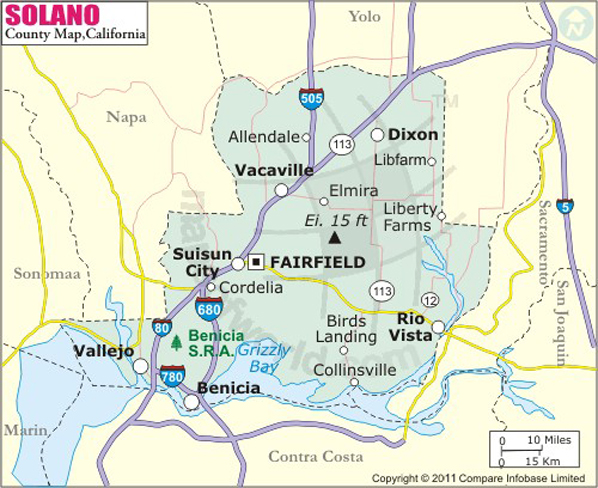
Solano County Map
Description:Map of Solano county showing the major towns, highways and much more. Disclaimer
×

Disclaimer  :  All efforts have been made to make this image accurate. However MapSherpa, Inc, its directors and employees do not own any responsibility for the correctness or authenticity of the same.


Solano County in California

Solano County is located in Northern California's North Bay region in San Francisco Bay Area. The county is spread over an area of 906 square miles. Out of nine counties in San Francisco Bay Area, it is the easternmost county of the North Bay. The county seat is Fairfield and the most populous city is Vallejo.

Known for its diverse population, the city of Vallejo sits on the northeastern shore of San Pablo Bay. The city of Fairfield lies roughly halfway between San Francisco and Sacramento, about 40 miles from both cities. Vacaville, Suisun and Benicia are other mid-sized cities in Solano County. The Western Railway Museum, Six Flags Discovery Kingdom, Benicia Capitol State Historic Park, Benicia State Recreation Area, Travis Air Force Base Heritage Center, and Lagoon Valley Park are top attractions in Solano County.

SolTrans and Vallejo Transit are some of the local transit agencies providing services to adjacent counties. Interstate 80 passes through Vallejo and Fairfield, while I-80 and I-505 converge in Vacaville. State Route 12, SR 113, and SR 29 are other highways in Solano County. Nearest commercial airports in San Francisco and Sacramento serve the county.

MOW.DT.01.12.17


Inside the page

Facts about Solano County

County NameSolano County
FoundedFeb 18, 1850
Area906 sq mi (2,350 km2)
Land Area822 sq mi (2,130 km2)
Water Area84 sq mi (220 km2)
Population413,344 (2010)
Largest cityVallejo (population) Fairfield (area)
CitiesFairfield, Vallejo, Vacaville, Benicia, Suisun City, Dixon, Rio Vista, Birds Landing, Rockville
County SeatFairfield
Time zonePacific Standard Time (UTC-8) Summer (DST) Pacific Daylight Time (UTC-7)

Cities and Towns in Solano County


CityPopulation
Allendale1,506
Benicia city26,997
Dixon city18,351
Elmira188
Fairfield city105,321
Green Valley1,625
Hartley2,510
Rio Vista city7,360
Suisun city28,111
Vacaville city92,428
Vallejo city115,942


Mountain Peaks in Solano County


Mountain Peak/HillElevation [Meter]
Cement Hill271
Drakes Point175
Dunns Peak241
Kirby Hill105
Luco Hill84
Putnam Peak349
Steiger Hill195
Suisun Hill61
Sulphur Springs Mountain331
Twin Sisters659
Vallejo Heights68

Airports in Solano County


Airport Name
Blake Sky Park Airport
Maine Prairie Airport
Nut Tree Airport
Rio Vista Municipal Airport
Travis Air Force Base
Travis Air Force Base Aero Club
Vaca Valley Hospital Heliport

Golf Courses in Solano County


Name of Golf CourseLatitudeLongitude
Blue Rock Springs Golf Club-Vallejo38.125218-122.191522
Cypress Lakes Golf Course-Vacaville38.322682-121.915501
Green Tree Golf Club-Vacaville38.381807-121.933878
Green Valley Country Club-Fairfield38.256504-122.167889
Hiddenbrooke Golf Club-Vallejo38.154525-122.181088
Joe Mortara Municipal Golf Course-Vallejo38.135148-122.229513
Mare Island Golf Club-Vallejo38.082979-122.26437
Paradise Valley Golf Course-Fairfield38.295701-122.025208
Rancho Solano Golf Course-Fairfield38.290779-122.071544
Rio Vista Golf Club-Rio Vista38.180717-121.717488


County Maps of California

Alameda County MapMarin County MapSan Luis Obispo County Map
Alpine County MapMariposa County MapSan Mateo County Map
Amador County MapMendocino County MapSanta Barbara County Map
Butte County MapMerced County MapSanta Clara County Map
Calaveras County MapModoc County MapSanta Cruz County Map
Colusa County MapMono County MapShasta County Map
Contra Costa County MapMonterey County MapSierra County Map
Del Norte County MapNapa County MapSiskiyou County Map
El Doredo County MapNevada County MapSolano County Map
Fresno County MapOrange County MapSonoma County Map
Glenn County MapPlacer County MapStanislaus County Map
Humboldt County MapPlumas County MapSutter County Map
Imperial County MapRiverside County MapTehama County Map
Inyo County MapSacramento County MapTrinity County Map
Kern County MapSan Benito County MapTulare County Map
Kings County MapSan Bernardino County MapTuolumne County Map
Lake County MapSan Diego County MapVentura County Map
Lassen County MapSan Francisco County MapYolo County Map
Los Angeles County MapSan Joaquin County MapYuba County Map
Madera County Map 


Map of Cities in California

Long Beach city MapOakland city MapAnaheim city Map
Santa Ana city MapRiverside city MapStockton city Map
Chula Vista city MapFremont city MapIrvine city Map
San Bernardino city MapModesto city MapOxnard city Map
Los Angeles city Map San Francisco city Map Sacramento city Map
San Jose city Map Bakersfield city Map Fullerton city Map


Last Updated Date: September 20th, 2021