logo


Sierra County Map

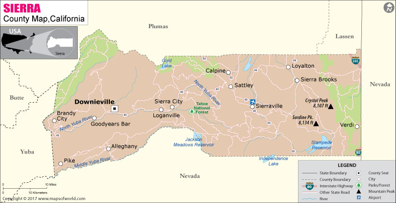
Below is the County Map of Sierra in California showing the boundaries, roads, highways, towns and much more.

Map of Sierra County, California
Sierra County Map
Description:Map of Sierra county showing the major towns, highways and much more. Disclaimer
×

Disclaimer  :  All efforts have been made to make this image accurate. However MapSherpa, Inc, its directors and employees do not own any responsibility for the correctness or authenticity of the same.


Inside the page

Facts about Sierra County

County NameSierra County
Founded1852
Area2,490 km2 (962 sq mi)
Land Area2,470 km2 (953 sq mi)
Water Area20 km2 (9 sq mi)
Population3,240 (2010)
Largest cityLoyalton
CitiesLoyalton
County SeatDownieville
Time zonePacific Standard Time (UTC-8)Summer (DST) Pacific Daylight Time (UTC-7)

Sierra County is located in Northern California's Sierra Nevada region adjacent to the state border with Nevada. Incorporated in 1852, it is the second least populous county in California. The county encompasses an area of 962 square miles. Downieville is the county seat and the only incorporated city is Loyalton.

Outdoor recreation and sites of the California Gold Rush are the main draw for suburbanites looking to spend a quiet weekend in the countryside. The "Downieville Downhill" trail has a 1,300-meter drop over its 17 miles length and is a popular route for mountain biking. Sierra Buttes North, Babbitt Peak, and Verdi Peak are notable summits in the region.

Stampede Reservoir, with 25 miles of shoreline, is an ideal spot for hiking, camping, and fishing. The rugged Plumas National Forest, with plenty of recreational offerings, extends into northwestern portion of the county and the Tahoe National Forest in the eastern Sierra County. State Route 49 is a major east-west corridor in the county, while SR 89 traverses north to south. Both state highways run contiguous between Sierraville and Sattley. Interstate 80 runs along the southeastern-most corner of the county.

MOW.DT.01.16.17


Mountain Peaks in Sierra County


Mountain Peak/HillElevation [Meter]
Alaska Peak1,225
American Hill1,558
Babbitt Peak2,664
Bald Mountain1,765
Bald Mountain1,681
Bald Top1,639
Beacon Point2,284
Beartrap Mountain2,172
Bunker Hill2,115
Burma Summit2,459
Cloud Splitter1,950
Crystal Peak2,461
Deadman Peak2,261
Deadwood Peak1,967
Democrat Peak2,061
Devils Post Pile1,813
Elephants Head1,991
Fillmore Hill1,591
Fir Cap1,972
Granite Mountain1,955
Granite Peak2,474
Graveyard Hill1,444
Grizzly Peak1,401
Harding Point1,806
Haskell Peak2,453
High Commission1,236
Indian Hill1,071
Keystone Mountain2,005
Ladybug Peak2,520
Land Peak2,442
Little Table Rock1,683
Millis Peak2,152
Mount Alma1,970
Mount Etna2,136
Mount Fillmore2,344
Mount Ina Coolbrith2,454
Needle Point2,129
Plug Point1,807
Poverty Hill1,673
Quartz Point1,631
Randolph Hill1,701
Rattlesnake Peak2,168
Red Dog1,360
Rice Hill1,638
Rocky Peak1,595
Saddleback Mountain2,018
Saint Charles Hill1,647
Sardine Peak2,468
Sardine Point2,287
Schroeder Mountain2,116
Sierra Buttes2,383
Skyhigh1,966
Snowden Hill1,221
Stafford Mountain2,105
Sugarloaf1,694
Sugarloaf1,747
Table Mountain1,737
Table Rock2,107
Tennessee Mountain1,928
The Mounds1,518
Treasure Mountain2,152
Verdi Peak2,566
Webber Peak2,466


Airports in Sierra County


Airport Name
Sierraville Dearwater Airport
Totem Pole Ranch Airport

Cities in Sierra County


CityPopulationLatitudeLongitude
Alleghany 5839.46666-120.841124
Calpine 20539.663294-120.443543
Downieville 28239.570066-120.821259
Goodyears Bar 6839.545769-120.888101
Loyalton city76939.676855-120.244811
Pike 13439.427966-120.999823
Sattley 4939.626504-120.435617
Sierra Brooks 47839.642593-120.215389
Sierra City 22139.574015-120.629656
Sierraville 20039.575044-120.363786
Verdi 16239.523693-120.016286


County Maps of California

Alameda County MapMarin County MapSan Luis Obispo County Map
Alpine County MapMariposa County MapSan Mateo County Map
Amador County MapMendocino County MapSanta Barbara County Map
Butte County MapMerced County MapSanta Clara County Map
Calaveras County MapModoc County MapSanta Cruz County Map
Colusa County MapMono County MapShasta County Map
Contra Costa County MapMonterey County MapSierra County Map
Del Norte County MapNapa County MapSiskiyou County Map
El Doredo County MapNevada County MapSolano County Map
Fresno County MapOrange County MapSonoma County Map
Glenn County MapPlacer County MapStanislaus County Map
Humboldt County MapPlumas County MapSutter County Map
Imperial County MapRiverside County MapTehama County Map
Inyo County MapSacramento County MapTrinity County Map
Kern County MapSan Benito County MapTulare County Map
Kings County MapSan Bernardino County MapTuolumne County Map
Lake County MapSan Diego County MapVentura County Map
Lassen County MapSan Francisco County MapYolo County Map
Los Angeles County MapSan Joaquin County MapYuba County Map
Madera County Map 


Last Updated Date: December 5th, 2017