logo


San Mateo County Map

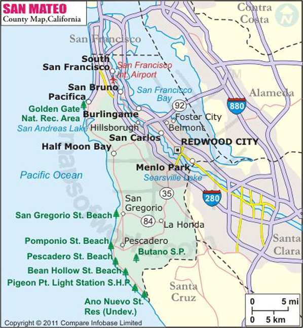
Below is the County Map of San Mateo in California showing the boundaries, roads, highways, towns and much more.

Map of San Mateo County, California
San Mateo County Map
Description:Map of San Mateo County showing the County boundaries, county seat, major cities, highways, roads, rail network, rivers & airports. Disclaimer
×

Disclaimer  :  All efforts have been made to make this image accurate. However MapSherpa, Inc, its directors and employees do not own any responsibility for the correctness or authenticity of the same.


San Mateo County, California


Founded in 1856, San Mateo County is located along the Central Pacific Coast in Northern California's San Francisco Bay Area region. With an area of 747 square miles, the county extends over most of the San Francisco Peninsula while encompassing redwood forests, coastal scrubs, and estuarines. It is the third smallest county in California by area. The county seat is Redwood City, while Daly City is the most populous.

The city of San Mateo lies halfway between San Francisco and San Jose in the high-tech enclave of Silicon Valley. San Francisco International Airport and San Jose Mineta International Airport are about 90 minutes away from San Mateo. SamTrans provides local bus transportation and Caltrain provides commuter rail service from Millbrae station. Interstate 280, State Route 1, and U.S. Route 101 are primary transportation corridors in San Mateo County.

Redwood City is a diverse cosmopolitan center with hillside neighborhoods in the Bay Area. Rancho Corral de Tierra, Purisima Creek Redwoods Open Space Preserve, Portola Redwoods State Park, and Butano State Park are prominent getaways in San Francisco Bay Area region.

MOW.DT.01.10.17


Cities and Towns in San Mateo County


CityPopulation
Atherton town6,914
Belmont city25,835
Brisbane city4,282
Broadmoor4,176
Burlingame city28,806
Colma town1,792
Daly city101,123
East Palo Alto city28,155
El Granada5,467
Emerald Lake Hills4,278
Foster city30,567
Half Moon Bay city11,324
Highlands-Baywood Park4,027
Hillsborough town10,825
La Honda928
Ladera1,426
Loma Mar113
Menlo Park city32,026
Millbrae city21,532
Montara2,909
Moss Beach3,103
North Fair Oaks14,687
Pacifica city37,234
Pescadero643
Portola Valley town4,353
Redwood city76,815
San Bruno city41,114
San Carlos city28,406
San Mateo city97,207
South San Francisco city63,632
West Menlo Park3,659
Woodside town5,287


Airports in San Mateo County


Airport Name
Half Moon Bay Airport
Palo Alto Airport of Santa Clara County
San Carlos Airport
San Francisco International Airport

Mountain Peaks in San Mateo County


Mountain Peak/HillElevation [Meter]
Bald Knob637
Belmont Hill171
Black Mountain198
Borel Hill769
Brittan Knoll65
Burns Chalks325
Cattle Hill247
Eagle Hill32
Goat Hill354
Haskins Hill356
Kelly Hill555
Kings Mountain638
Lane Hill374
Langley Hill677
Mindego Hill653
Montara Knob495
Morena Sierra731
Mount Ellen201
Mount Melville672
North Peak575
Ox Hill539
Peak Mountain551
Point San Bruno46
Rays Peak287
Round Hill28
San Bruno Mountain371
San Pedro Mountain323
Scarpet Peak589
Skeggs Point703
South Peak555
Sugarloaf Hill177
Teague Hill612
Windy Hill585


Golf Courses in San Mateo County


Name of Golf CourseLatitudeLongitude
Burlingame Country Club-Hillsborough37.568214-122.369115
California Golf Club of San Francisco-South San Francisco37.652947-122.436366
Crystal Springs Golf Course-Burlingame37.553868-122.378926
Emerald Hills Golf Course-Redwood City37.455629-122.265478
Green Hills Country Club-Millbrae37.605188-122.407033
Half Moon Bay Golf Links-Half Moon Bay37.425244-122.426848
Kings Mountain Golf Course-Woodside37.428416-122.270147
Lake Merced Golf Club-Daly City37.694878-122.471133
Mariners Point Golf Links-Foster City37.57085-122.284146
Menlo Country Club-Woodside37.442695-122.235669
Peninsula Golf & Country Club-San Mateo37.541816-122.320732
Poplar Creek Golf Course-San Mateo37.587719-122.32527
Sharon Heights Golf & Country Club-Menlo Park37.420658-122.216145
Sharp Park Golf Course-Pacifica37.625189-122.488477
The Olympic Club-Daly City37.679834-122.490645


Map of Cities in California

Long Beach city MapOakland city MapAnaheim city Map
Santa Ana city MapRiverside city MapStockton city Map
Chula Vista city MapFremont city MapIrvine city Map
San Bernardino city MapModesto city MapOxnard city Map
Los Angeles city Map San Francisco city Map Sacramento city Map
San Jose city Map Bakersfield city Map Fullerton city Map


Last Updated Date: September 20th, 2021