logo


San Joaquin County Map

Below is County Map of San Joaquin in California showing the boundaries, roads, highways, towns and much more.

Map of San Joaquin County in California
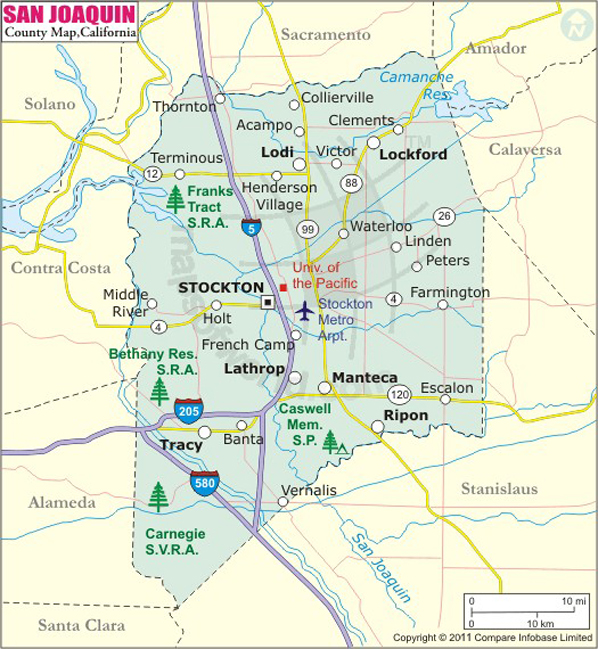
San Joaquin County Map
Description:San Joaquin County Map showing the County boundaries, County seat, major cities, highways, roads, rail network, airports and point of interest. Disclaimer
×

Disclaimer  :  All efforts have been made to make this image accurate. However MapSherpa, Inc, its directors and employees do not own any responsibility for the correctness or authenticity of the same.


Inside the page

Facts about San Joaquin County

County NameSan Joaquin County
FoundedFeb 18, 1850
Area1,426 sq mi (3,690 km2)
Land Area1,391 sq mi (3,600 km2)
Water Area35 sq mi (90 km2)
Population685,306 (2010)
Largest cityStockton (population and area)
County SeatStockton
Time zonePacific Standard Time (UTC-8)Summer (DST) Pacific Daylight Time (UTC-7)

With an area of 1,426 square miles, San Joaquin County is located in the Central Valley of Northern California. Its county seat and the largest city is Stockton. Named after Robert F. Stockton , it was the first community in California without a Spanish or Native American origin in its name.


Manteca, Escalon, Tracy, Lodi, and Ripon are notable cities in San Joaquin County. Stockton Metropolitan Airport (SCK) is served by direct flights to and from Las Vegas, San Diego, and Phoenix. Major highways in San Joaquin County include Interstate 5, State Route 99, SR 4, and SR 12. Amtrak's San Joaquins train stops at the Robert J. Cabral Station in Stockton. Port of Stockton on the San Joaquin River is a major inland deep-water port in California.

The University of the Pacific and San Joaquin Delta College are notable institutions in the county. Stockton Symphony is the third oldest orchestra in California. The famous Haggin Museum exhibits 19th and 20th-century artworks and local historical collections. Outdoor murals, downtown art galleries, and annual festivals such as Stockton Asparagus Festival and Stockton Beer Week make the city a popular destination to visit.

MOW.DT.01.09.17


Cities in San Joaquin County


CityPopulation
  • Acampo
  • 341
  • August
  • 8,390
  • Collierville
  • 1,934
  • Country Club
  • 9379
  • Dogtown
  • 2,506
  • Escalon city
  • 7,132
  • Farmington
  • 207
  • French Camp
  • 3,376
  • Garden Acres
  • 10,648
  • Kennedy
  • 3,254
  • Lathrop city
  • 18,023
  • Lincoln Village
  • 4,381
  • Linden
  • 1,784
  • Lockeford
  • 3,233
  • Lodi city
  • 62,134
  • Manteca city
  • 67,096
  • Morada
  • 3,828
  • Mountain House
  • 9,675
  • Peters
  • 672
  • Ripon city
  • 14,297
  • Stockton city
  • 291,707
  • Taft Mosswood
  • 1,530
  • Terminous
  • 381
  • Thornton
  • 1,131
  • Tracy city
  • 82,922
  • Victor
  • 293
  • Waterloo
  • 572
  • Woodbridge
  • 3,984


    Airports in San Joaquin County


    Airport Name
    33 Strip
    A G Spanos Companies Hq Heliport
    Cortopassi Airport
    Faber Vineyards Airport
    Ferdun Ranch Airport
    Fowler's Airport
    Harley Airport
    J-B Airport
    Jones Heliport
    Kingdon Airpark
    Lodi Airpark
    Lodi Airport
    Lodi Memorial Hospital Heliport
    Lost Isle Seaplane Base
    New Jerusalem Airport
    San Joaquin General Hospital Heliport
    Stockton Metropolitan Airport
    Tracy Municipal Airport
    Vetters Sky Ranch Airport
    Wallom Field

    Mountain Peaks in San Joaquin County


    Mountain Peak/HillElevation [Meter]
    Bald Mountain867
    Black Butte331
    Cedar Knob614
    Eagle Mountain921


    Golf Courses in San Joaquin County


    Name of Golf CourseLatitudeLongitude
    Brookside Country Club-Stockton37.979185-121.360097
    Elkhorn Country Club-Stockton38.052036-121.327778
    Escalon Golf Course-Escalon37.808631-120.997209
    Forest Lake Golf Course-Acampo38.216351-121.288714
    French Camp RV Park and Golf Course-Manteca37.860938-121.221594
    J.B. Golf Course-Farmington37.9299-121.009279
    Jack Tone Golf-Ripon37.726957-121.144567
    Lockeford Springs Golf Course-Lodi38.130884-121.166004
    Lyons Golf Course-Stockton37.948903-121.337823
    Manteca Park Golf Course-Manteca37.801007-121.235153
    Micke Grove Golf Links-Lodi38.076186-121.269234
    Oakmoore Golf Course-Stockton37.991685-121.266755
    Old River Golf Course-Banta37.797778-121.412227
    Spring Creek Golf & Country Club-Ripon37.745153-121.109418
    Stockton Golf & Country Club-Stockton37.961951-121.353658
    Swenson Park Golf Club-Stockton38.009502-121.339482
    The Reserve At Spanos Park-Stockton38.057929-121.39109
    Tracy Golf & Country Club-Tracy37.633532-121.397411
    Van Buskirk Municipal Golf Course-Stockton37.920849-121.310573
    Venetian Gardens Golf Course-Stockton37.991281-121.325994
    Woodbridge Golf & Country Club-Woodbridge38.162941-121.304735


    Map of Cities in California

    Long Beach city MapOakland city MapAnaheim city Map
    Santa Ana city MapRiverside city MapStockton city Map
    Chula Vista city MapFremont city MapIrvine city Map
    San Bernardino city MapModesto city MapOxnard city Map
    Los Angeles city Map San Francisco city Map Sacramento city Map
    San Jose city Map Bakersfield city Map Fullerton city Map


    Last Updated Date: September 20th, 2021