logo


Sacramento County Map

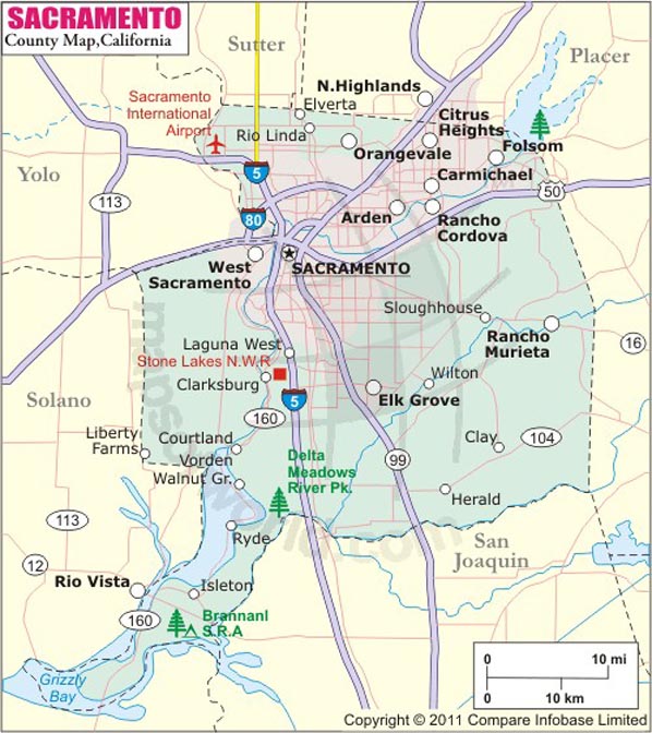
Below is County Map of Sacramento in California showing the boundaries, roads, highways, towns and much more.

Map of Sacramento County, California
Sacramento County Map
Description:Map of Sacramento county showing the major towns, highways and much more. Disclaimer
×

Disclaimer  :  All efforts have been made to make this image accurate. However MapSherpa, Inc, its directors and employees do not own any responsibility for the correctness or authenticity of the same.


Sacramento County in California


Covering about 994 square miles, Sacramento County is located in the northern section of the Central Valley in Northern California. Known as “City of Trees,” Sacramento is the county seat and the sixth largest city in California. The city is also the state capital since 1854. The city is located at the meeting point of the Sacramento River and the American River.


The county's geographical features are highlighted by the low delta lands in the west and the foothills of the Sierra Nevada Mountains in the east. The Sacramento River marks the county's western border. Interstate 5 and I-80 intersect in Sacramento. US 50, SR 16, and SR 84 are secondary corridors in the county. Sacramento International Airport (SMF) is a major airport with passenger flights including Southwest Airlines. The Sacramento Valley Station is served by Amtrak's California Zephyr, Coast Starlight, Capitol Corridor, and San Joaquin routes.

The Old Sacramento State Historic Park, California State Railroad Museum, Crocker Art Museum, California State Capitol Museum, Sutter's Fort, Folsom Lake, and Discovery Park are must-visit attractions in Sacramento County.

MOW.DT.01.04.16


Inside the page

Facts about Sacramento County

County NameSacramento County
FoundedFeb 18, 1850
Area994 sq mi (2,570 km2)
Land Area965 sq mi (2,500 km2)
Water Area29 sq mi (80 km2)
Population1,418,788 (2010)
Largest citySacramento (population and area)
County SeatSacramento
Time zonePacific Standard Time (UTC 8) Summer (DST) Pacific Daylight Time (UTC 7)

Cities in Sacramento County


CityCountyPopulation
  • Antelope
  • Sacramento45,770
  • Arden-Arcade
  • Sacramento92,186
  • Carmichael
  • Sacramento61,762
  • Citrus Heights city
  • Sacramento83,301
  • Clay
  • Sacramento1,195
  • Courtland
  • Sacramento355
  • Elk Grove city
  • Sacramento153,015
  • Elverta
  • Sacramento5,492
  • Fair Oaks
  • Sacramento30,912
  • Florin
  • Sacramento47,513
  • Folsom city
  • Sacramento72,203
  • Foothill Farms
  • Sacramento33,121
  • Franklin
  • Sacramento155
  • Freeport
  • Sacramento38
  • Fruitridge Pocket
  • Sacramento5,800
  • Galt city
  • Sacramento23,647
  • Gold River
  • Sacramento7,912
  • Herald
  • Sacramento1,184
  • Hood
  • Sacramento271
  • Isleton city
  • Sacramento804
  • La Riviera
  • Sacramento10,802
  • Lemon Hill
  • Sacramento13,729
  • Mather
  • Sacramento4,451
  • McClellan Park
  • Sacramento743
  • North Highlands
  • Sacramento42,694
  • Orangevale
  • Sacramento33,960
  • Parkway
  • Sacramento14,670
  • Rancho Cordova city
  • Sacramento64,776
  • Rancho Murieta
  • Sacramento5,488
  • Rio Linda
  • Sacramento15,106
  • Rosemont
  • Sacramento22,681
  • Vineyard
  • Sacramento24,836
  • Walnut Grove
  • Sacramento1,542
  • Wilton
  • Sacramento5,363


    Mountain Peaks in Sacramento County


    Mountain Peak/HillElevation [Meter]
    Whisky Hill10

    Airports in Sacramento County


    Airport Name
    Boeckmann Ranch Airport
    Bottimore Ranch Airport
    Elk Grove Airport
    Flying B Ranch Airport
    Flying R Airport
    Franklin Field
    Lake Park Helistop
    Lucchetti Ranch Airport
    Mc Clellan Airfield
    Mercy San Juan Hospital Heliport
    Mosier Airport
    Mustang Airport
    Rancho Murieta Airport
    Rio Linda Airport
    Sacramento Executive Airport
    Sacramento International Airport
    Sacramento Mather Airport
    Sky Way Estates Airport
    Spezia Airport
    Sunrise One Heliport
    Uc Davis Medical Center Life Flight Base Heliport
    Uc Davis Medical Center Tower Ii Heliport
    Van Vleck Airport


    Golf Courses in Sacramento County


    Name of Golf CourseLatitudeLongitude
    Ancil Hoffman Golf Course-Carmichael38.610649-121.309188
    Antelope Green Golf Course-Antelope38.71449-121.398288
    Bartley Cavanaugh Golf Course-Sacramento38.456573-121.500456
    Bing Maloney Golf Course-Sacramento38.502603-121.505603
    Bradshaw Ranch Golf Course-Sacramento38.490906-121.335047
    Campus Commons Golf Center-Sacramento38.575483-121.417839
    Champions Golf Links-Sacramento38.48177-121.369957
    Cherry Island Golf Course-Elverta38.714138-121.408271
    Cordova Golf Course-Sacramento38.532264-121.346652
    Del Paso Country Club-Sacramento38.618774-121.387109
    Dry Creek Ranch Golf Course-Galt38.248269-121.287651
    Emerald Lakes Golf Center & Driving Range-Elk Grove38.372105-121.357014
    Empire Ranch Golf Club-Folsom38.68493-121.112487
    Foothills Golf Center-Sacramento38.693393-121.324102
    Haggin Oaks Golf Course-Sacramento38.632296-121.401323
    Mather Golf Course-Mather38.554526-121.261275
    North Ridge Country Club-Fair Oaks38.663586-121.284423
    Rancho Murieta Country Club-Rancho Murieta38.494925-121.089596
    Sunrise Golf Course-Citrus Heights38.682615-121.271404
    Swallows Nest Country Club-Sacramento38.608631-121.530361
    Teal Bend Golf Course-Sacramento38.700809-121.623563
    Valley Hi Country Club-Elk Grove38.411783-121.449299
    WildHawk Golf Club-Sacramento38.478094-121.31592
    William Land Golf Course-Sacramento38.536169-121.498448


    Map of Cities in California

    Long Beach city MapOakland city MapAnaheim city Map
    Santa Ana city MapRiverside city MapStockton city Map
    Chula Vista city MapFremont city MapIrvine city Map
    San Bernardino city MapModesto city MapOxnard city Map
    Los Angeles city Map San Francisco city Map Sacramento city Map
    San Jose city Map Bakersfield city Map Fullerton city Map


    Last Updated Date: September 20th, 2021