logo


Plumas County Map

Below is County Map of Plumas in California showing the boundaries, roads, highways, towns and much more.

Map of Plumas County, California
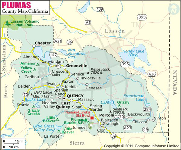
Plumas County Map
Description:Map of Plumas county showing the major towns, highways and much more. Disclaimer
×

Disclaimer  :  All efforts have been made to make this image accurate. However MapSherpa, Inc, its directors and employees do not own any responsibility for the correctness or authenticity of the same.


Inside the page

Facts about Plumas County

County NamePlumas County
Founded1854
Area2,613 sq mi (6,770 km2)
Land Area2,553 sq mi (6,610 km2)
Water Area60 sq mi (200 km2)
Population20,007 (2010)
CitiesPortola
County SeatQuincy
Time zonePacific Standard Time (UTC-8)Summer (DST) Pacific Daylight Time (UTC-7)

About Plumas County, CA


Plumas County located in the far northern end of the Sierra Nevada range in Northern California. The name of the county is the Spanish word for the Feather River. The county seat is Quincy and the only incorporated city is Portola. The largest settlement in the county is East Quincy. Plumas county comprises an area of 2,613 square miles. Its rugged landscape marks the transition between the northern Sierra Nevadas and the southern Cascade range. Some land of Lassen Volcanic National Park covers the northwest corner of the county.

The 1,200,000 acres of Plumas National Forest offer a wide range of recreational opportunities including hiking, camping, swimming, mountain biking, and fishing. The protected area is home to more than 100 lakes such as Lake Almanor, Lake Davis, Frenchman Lake, Little Grass Valley Reservoir. Born out of the early 20th-century mining and logging, the small town of Portola houses the Western Pacific Railroad Museum, one of the largest railroad museums in North America. The Plumas County Museum in Quincy exhibits Maidu Indian and Gold Rush artifacts.

The Feather River National Scenic Byway runs along the Middle and North Forks of the Feather River. It allows spectacular views of steep canyon walls, high mountain valleys, grasslands, and oak woodlands. State Route 70 and SR 89 pass through the county.

MOW.DT.01.17.17

Cities and Towns in Plumas County


CityPopulation
Beckwourth432
Chester2,144
Chilcoot-Vinton454
Crescent Mills196
Cromberg261
Delleker705
East Quincy2,489
Graeagle737
Greenhorn236
Greenville1,129
Hamilton Branch537
Iron Horse297
Lake Almanor Country Club419
Lake Almanor Peninsula356
Lake Almanor West270
Mabie161
Meadow Valley464
Plumas Eureka339
Portola city2,104
Quincy1,728


Mountain Peaks in Plumas County


Mountain Peak/HillElevation [Meter]
Argentine Rock2,190
Arlington Heights2,089
Babcock Peak2,138
Bald Eagle Mountain2,179
Bald Rock2,181
Bean Hill1,372
Beckwourth Peak2,200
Ben Lomond1,945
Big Hill1,736
Big Peak1,686
Blue Nose Mountain2,217
Bonte Peak2,344
Brush Hill1,862
Brush Hill1,848
Bucks Mountain2,068
Bucks Summit1,663
Cairn Butte2,224
Camel Peak1,737
Castle Rocks1,961
Chambers Peak1,838
Chambers Peak1,858
Cherry Hill1,756
Chimney Rock1,830
Claremont2,106
Clarks Peak2,168
Cold Spring Hill1,906
Cottonwood Mountain1,949
Crescent Hill1,985
Crocker Mountain2,269
Diamond Springs Hill1,398
Dixie Mountain2,537
Dogwood Peak1,856
Duffey Dome1,684
Eagle Rocks2,149
East Claremont2,091
Eisenheimer Peak2,287
Eureka Peak2,183
Evans Peak1,624
Finger Board2,093
Fowler Peak1,843
Franklin Hill1,743
Frenchman Hill1,805
Gibraltar2,210
Glazer Point1,645
Goat Mountain1,737
Gopher Hill1,193
Grass Valley Bald Mountain1,908
Grizzly Dome1,501
Grizzly Peak2,325
Grizzly Summit1,778
Humboldt Peak2,147
Humbug Summit2,007
Hunodim Peak1,621
Jennie Mountain1,882
Johnson Hill1,366
Johnson Hill2,000
Kelly Mountain2,088
Kennedy Butte1,046
Kessler Peak1,925
Kettle Rock2,377
Kusim Hill1,127
La Porte Bald Mountain1,794
Lava Peak1,747
Lexington Hill1,757
Little Marble Cone1,421
Little Peak1,662
Little Volcano1,765
Lone Spring Mountain1,983
Lower Taylor2,137
Manzanita Mountain1,790
McElroy Hill1,686
Moonlight Peak2,069
Mount Ararat1,781
Mount Elwell2,361
Mount Harkness2,452
Mount Hope2,007
Mount Hough2,201
Mount Ingalls2,542
Mount Jackson2,000
Mount Jura1,892
Mount Pleasant2,150
Mount Washington2,236
Mud Creek Butte1,910
North Stover Mountain1,825
Old Ski Hill1,468
Papoose Peak2,047
Penman Peak2,193
Pilot Peak2,271
Radio Hill1,199
Rattlesnake Hill1,882
Rattlesnake Peak2,260
Reconnaissance Peak2,285
Red Hill1,928
Red Mountain1,935
Red Rock2,307
Rocky Point1,518
Round Mountain1,948
Rush Creek Hill1,930
Sifford Mountain2,250
Ski Hill1,566
Small Butte1,821
Smith Peak2,330
Soapstone Hill1,670
Spanish Peak2,126
Spring Valley Mountain2,081
Star Butte2,040
Stover Mountain1,865
Sugar Loaf1,946
Sugar Loaf Mountain1,080
Sugarloaf1,975
Swain Mountain2,111
Table Mountain1,864
Table Rock1,851
Tankusim Hill1,101
Tanners Rock2,197
Taylor Rock2,220
The Big Hill1,471
The Buttes1,643
The Island1,268
Thompson Peak2,362
Threemile Rock1,946
Tower Rock2,342
Turn Table1,492
Wapunbem Hill1,079
Washington Hill2,079
Wheeler Peak2,220
Whiskey Hill1,418
White Cap1,965
Wild Cattle Mountain1,872
Yankee Hill1,446


Airports in Plumas County


Airport Name
Gansner Field
Indian Valley Hospital Heliport
Nervino Airport
Plumas District Hospital Heliport
Quincy Helitack Base Heliport
Rodgers Flat Heliport
Rogers Field
US Forest Service Chester Heliport

Golf Courses in Plumas County


Name of Golf CourseLatitudeLongitude
Bailey Creek Golf Course-Lake Almanor40.291386-121.140473
Dragon At Gold Mountain-Clio39.743928-120.582232
Feather River Park Resort-Blairsden39.809133-120.703549
Graeagle Meadows Golf Course-Graeagle39.7643-120.616409
Grizzly Ranch Golf Club-Portola39.844548-120.423312
Lake Almanor Country Club-Westwood40.248064-121.150854
Lake Almanor West Golf Course-Chester40.244403-121.214148
Mount Huff Golf Course-Crescent Mills40.090599-120.914365
Plumas Pines Golf Resort-Blairsden39.798425-120.670064
Whitehawk Ranch Golf Club-Clio39.718999-120.537549

National Parks in Plumas County


Name of ParkLatitudeLongitude 
Lassen Volcanic NP40.494117-121.40578


County Maps of California

Alameda County MapMarin County MapSan Luis Obispo County Map
Alpine County MapMariposa County MapSan Mateo County Map
Amador County MapMendocino County MapSanta Barbara County Map
Butte County MapMerced County MapSanta Clara County Map
Calaveras County MapModoc County MapSanta Cruz County Map
Colusa County MapMono County MapShasta County Map
Contra Costa County MapMonterey County MapSierra County Map
Del Norte County MapNapa County MapSiskiyou County Map
El Doredo County MapNevada County MapSolano County Map
Fresno County MapOrange County MapSonoma County Map
Glenn County MapPlacer County MapStanislaus County Map
Humboldt County MapPlumas County MapSutter County Map
Imperial County MapRiverside County MapTehama County Map
Inyo County MapSacramento County MapTrinity County Map
Kern County MapSan Benito County MapTulare County Map
Kings County MapSan Bernardino County MapTuolumne County Map
Lake County MapSan Diego County MapVentura County Map
Lassen County MapSan Francisco County MapYolo County Map
Los Angeles County MapSan Joaquin County MapYuba County Map
Madera County Map 


Map of Cities in California

Long Beach city MapOakland city MapAnaheim city Map
Santa Ana city MapRiverside city MapStockton city Map
Chula Vista city MapFremont city MapIrvine city Map
San Bernardino city MapModesto city MapOxnard city Map
Los Angeles city Map San Francisco city Map Sacramento city Map
San Jose city Map Bakersfield city Map Fullerton city Map


Last Updated Date: September 20th, 2021