logo


Placer County Map

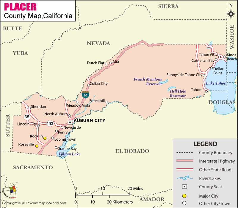
Below is County Map of Placer in California showing the boundaries, roads, highways, towns and much more.

Map of Placer County, California
Placer County Map
Description:Map of Placer county showing the major towns, highways and much more. Disclaimer
×

Disclaimer  :  All efforts have been made to make this image accurate. However MapSherpa, Inc, its directors and employees do not own any responsibility for the correctness or authenticity of the same.


About Placer County, CA


Founded in 1851, Placer County is located near the state's eastern border with Nevada in the Gold Country region in Northern California. The county seat is Auburn and the most populous city is Roseville. The county is a part of both the Sacramento Valley and Sierra Nevada regions. With an area of 1,502 square miles, it stretches from the suburbs of Sacramento in the west to Lake Tahoe in the east. Lake Tahoe, the largest alpine lake in North America, covers 40.96% of its surface area in Placer County.

The city of Auburn, like most places in the county, has a well-recorded history during the California Gold Rush. The county features breath-taking alpine scenery, rich heritage, and year-round recreation. Eldorado National Forest (in south) and Tahoe National Forest (in east) are major wilderness areas. Northstar California Resort, Lake Clementine, Bernhard Museum Complex, Folsom Lake State Recreation Area, and Maidu Museum & Historic Site are popular places to visit in Placer County.


Sacramento International Airport (SMF) is the closest commercial airport from the county. Placer County Transit (PCT) provides local bus service along the I-80 corridor and commuter service to Downtown Sacramento. Amtrak's Capitol Corridor route serves Roseville and Auburn. Interstate 80 is the main transportation artery of the county. Secondary highways include State Route 89, SR 28, and SR 65.

MOW.DT.01.13.17

Inside the page

Facts about Placer County

County NamePlacer County
Founded1851
Area1,502 sq mi (3,890 km2)
Land Area1,407 sq mi (3,640 km2)
Water Area95 sq mi (250 km2)
Population348,432 (2010)
Largest cityRoseville (population and area)
County SeatAuburn
Time zonePacific Standard Time (UTC-8) Summer (DST) Pacific Daylight Time (UTC-7)

Cities and Towns in Placer County


CityPopulation
Alta610
Auburn city13,330
Carnelian Bay524
Colfax city1,963
Dollar Point1,215
Foresthill1,483
Granite Bay20,402
Kings Beach3,796
Lincoln city42,819
Loomis town6,430
Meadow Vista3,217
Newcastle1,224
North Auburn13,022
Penryn831
Rocklin city56,974
Roseville city118,788
Sheridan1,238
Sunnyside-Tahoe City1,557
Tahoe Vista1,433
Tahoma1,191


Mountain Peaks in Placer County


Mountain Peak/HillElevation [Meter]
American Hill1566
Anderson Peak2646
Bald Hill405
Bald Mountain2060
Bald Rock Mountain513
Barker Peak2489
Big Chief2234
Big Hill483
Big John Hill685
Billys Peak2623
Black Mountain2131
Bogus Point1104
Brockway Summit2197
Bullshead1927
Bunker Hill2300
Camels Hump803
Canada Hill2048
Cherry Point2048
Cisco Butte2015
Cold Spring Hill1123
Colfax Hill870
Cottage Home Hill1246
Coyote Hill737
Crows Nest2404
Devil Peak1611
Devils Peak2296
Devils Peak2290
Donner Peak2435
Duncan Hill390
Duncan Peak2160
Eagle Rock1916
Ellis Peak2648
First Sugarloaf936
Frost Hill1195
Gold Star Peak2359
Granite Chief2749
Guide Peak2329
Hayden Hill1159
Hayford Hill980
Helester Point1479
Hotchkiss Hill710
Howell Hill793
Indian Knoll843
Jackass Point1942
Jerrett Peak2287
Kings Hill929
Kings Hill Point790
KT-222430
Little Bald Mountain2190
Little Chief2210
Little Sage Hill661
Little Steamboat Mountain2075
Lookout Mountain2466
Lynchburg Hill1388
Lyon Peak2713
Martis Peak2656
McIntosh Hill2064
McKinstry Peak2415
Mount Disney2421
Mount Judah2513
Mount Lincoln2551
Mount Mildred2551
Mount Pluto2625
Mount Watson2566
Needle Peak2711
Painted Rock2353
Painted Rock2035
Pennsylvania Point1054
Poulsen Peak2353
Quartz Mountain2125
Race Track Hill898
Red Hill880
Red Star Point1493
Roach Hill1131
Robie Point367
Sage Hill1116
Scott Hill1625
Scott Peak2517
Second Sugarloaf933
Silver Peak2556
Snakehead Point739
Snow Mountain2436
Spaulding Point1333
Steamboat Mountain2236
Stony Hill580
Sugar Loaf1147
Sugar Pine Mountain612
Sugar Pine Point1882
Sugarloaf218
Sugarloaf1278
Sunflower Hill2137
Tanners Point1256
Telegraph Hill118
Texas Hill1704
The Pinnacles2306
Tinker Knob2713
Twin Peaks2701
Volcano Hill129
Wallace Peak1863
Ward Peak2622
Whisky Hill1776

Airports in Placer County


Airport Name
Auburn Cdf Heliport
Auburn Municipal Airport
Blue Canyon Nyack Airport
Fiddyment Field
Holtsmans Airport
Lincoln Regional Karl Harder Field
Pg&E Auburn Service Center Heliport


Golf Courses in Placer County


Name of Golf CourseLatitudeLongitude
Auburn Valley Golf & Country Club-Auburn39.003903-121.148646
Black Oak Golf Course-Auburn38.967392-121.071228
Catta Verdera Country Club At Twelve Bridges-Lincoln38.854117-121.243325
Diamond Oaks Municipal Golf Course-Roseville38.767503-121.28493
Granite Bay Golf Club-Granite Bay38.724564-121.19486
Indian Creek Country Club Inc-Loomis38.803173-121.188917
Lahontan Golf Club-Truckee39.294526-120.150681
Morgan Creek Golf and Country Club-Roseville38.739388-121.34743
Northstar At Tahoe Golf Course-Truckee39.286677-120.107743
Old Brockway Golf Club-Kings Beach39.238911-120.033641
Raspberry Hills Golf Course-Auburn38.944907-121.044616
Resort At Squaw Creek-Olympic Valley39.198031-120.218133
Rolling Greens Golf Course-Granite Bay38.736127-121.197104
Sierra View Country Club-Roseville38.758702-121.288728
Sunset Whitney Country Club-Rocklin38.805987-121.244616
Tahoe City Golf Course-Tahoe City39.168643-120.144026
The Lincoln Hills Club-Lincoln38.869129-121.274404
The Ridge Golf Course-Auburn38.948724-121.076914
The Timilick Club-Truckee39.305839-120.162737
Timber Creek Golf Course At Sun City Roseville-Roseville38.777438-121.348362
Turkey Creek Golf Course-Lincoln38.886676-121.265235
Whitney Oaks Golf Club-Rocklin38.824777-121.240207
Winchester Country Club-Meadow Vista38.989301-121.047297
Woodcreek Golf Club-Roseville38.776796-121.332639

County Maps of California

Alameda County MapMarin County MapSan Luis Obispo County Map
Alpine County MapMariposa County MapSan Mateo County Map
Amador County MapMendocino County MapSanta Barbara County Map
Butte County MapMerced County MapSanta Clara County Map
Calaveras County MapModoc County MapSanta Cruz County Map
Colusa County MapMono County MapShasta County Map
Contra Costa County MapMonterey County MapSierra County Map
Del Norte County MapNapa County MapSiskiyou County Map
El Doredo County MapNevada County MapSolano County Map
Fresno County MapOrange County MapSonoma County Map
Glenn County MapPlacer County MapStanislaus County Map
Humboldt County MapPlumas County MapSutter County Map
Imperial County MapRiverside County MapTehama County Map
Inyo County MapSacramento County MapTrinity County Map
Kern County MapSan Benito County MapTulare County Map
Kings County MapSan Bernardino County MapTuolumne County Map
Lake County MapSan Diego County MapVentura County Map
Lassen County MapSan Francisco County MapYolo County Map
Los Angeles County MapSan Joaquin County MapYuba County Map
Madera County Map 


Map of Cities in California

Long Beach city MapOakland city MapAnaheim city Map
Santa Ana city MapRiverside city MapStockton city Map
Chula Vista city MapFremont city MapIrvine city Map
San Bernardino city MapModesto city MapOxnard city Map
Los Angeles city Map San Francisco city Map Sacramento city Map
San Jose city Map Bakersfield city Map Fullerton city Map


Last Updated Date: September 20th, 2021