logo


Nevada County Map

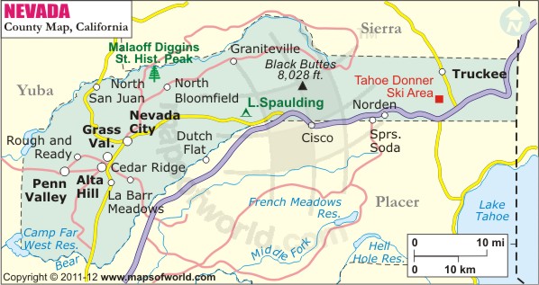
Map of Nevada county showing the major towns, highways and much more.

Map of Nevada County, California
Nevada County Map
Description:Nevada County Map shows the county boundaries, major cities, highways, roads, rail network and mountain peaks. Disclaimer
×

Disclaimer  :  All efforts have been made to make this image accurate. However MapSherpa, Inc, its directors and employees do not own any responsibility for the correctness or authenticity of the same.


Inside the page

Facts about Nevada County

County NameNevada County
Founded1851
Area974 sq mi (2,520 km2)
Land Area958 sq mi (2,480 km2)
Water Area16 sq mi (40 km2)
Population98,764 (2010)
Largest cityTruckee (population and area)
County SeatNevada City
Time zonePacific Standard Time (UTC-8) Summer (DST) Pacific Daylight Time (UTC-7)

Created in 1851, Nevada County is located in the Sierra Nevada region of California. Its name Nevada is Spanish for "snowy." The county seat is Nevada City and the largest city is Truckee. The county was known for its mineral deposits as it is located in the Mother Lode Country, a historic region in California. It encompasses a total area of 974 square miles. Grass Valley, Alta Sierra, Lake Wildwood, and Washington are other populated areas in the county.


The western portion of the county define the course of several rivers. Martis Creek Lake and Dam stands at the southern end of Nevada County. The Martis Valley, which is largely rural and forested, ranges between 5,800 to 8,600 feet in elevation. The county is a popular weekend getaway for visitors from Greater Sacramento and Northern California. South Yuba River State Park in Nevada City offers outdoor recreation in the form of year-round hiking and gold panning. Major tourist attractions in the county include Empire Mine State Historic Park, Nevada County Narrow Gauge Railroad Museum, Castle Peak & Donner Pass, and Sugar Bowl Ski Resort.

Interstate 80, for most of its course, runs along the southern border of the county and passes through the town of Truckee. The Truckee-Tahoe Airport, a general aviation facility, provides access to the North Lake Tahoe region. Amtrak's California Zephyr makes a stop in Truckee and Colfax.

MOW.DT.01.18.17


Cities and Towns in Nevada County


CityPopulation
Alta Sierra6,911
Grass Valley city12,860
Kingvale143
Lake of the Pines3,917
Lake Wildwood4,991
Nevada city3,068
North San Juan269
Penn Valley1,621
Rough and Ready963
Soda Springs81
Truckee town16,180
Washington185


Mountain Peaks in Nevada County


Mountain Peak/HillElevation [Meter]
Alder Hill2,049
Allenwood Hill404
American Ranch Hill749
Andesite Peak2,504
Bald Mountain446
Bald Mountain949
Banner Mountain1,188
Basin Peak2,749
Billy Hill2,043
Black Buttes2,433
Boca Hill2,028
Bowman Mountain2,250
Brady Mountain1,814
Buck Mountain689
Buck Mountain1,071
Bunker Hill794
Burned Hill2,415
Bushy Mountain401
Buzzard Roost2,467
Camel Hump1,090
Castle Peak2,773
Cherry Hill1,580
Clyde Mountain1,846
Cole Hill551
Columbia Hill1,190
Cottage Hill522
Egbert Hill524
English Mountain2,549
Fall Creek Mountain2,255
Fattebort Hill583
Findley Peak2,261
Fir Hill2,113
Fordyce Summit2,196
George R. Stewart Peak2,237
George Washington Hill499
Goat Rock754
Gold Hill752
Granite Hill733
Haney Mountain544
Hartley Butte2,256
Haystack Mountain2,247
Hog Hill501
Iron Mountain472
Iron Mountain566
Juniper Hill2,381
Lucas Hill454
McGlashan Point2,098
McGuire Mountain1,352
Meadow Lake Hill2,382
Montezuma Hill876
Mount Lola2,774
Mount Marliave2,176
Mount Olive785
Mount Stephens2,211
Negro Jack Hill1,401
Old Man Mountain2,362
Ophir Hill836
Osborne Hill933
Peardon Hill386
Pilot Peak663
Pine Hill555
Pine Hill649
Pinoli Peak2,213
Piper Hill544
Prosser Hill2,181
Pyramid Peak1,796
Quaker Hill1,126
Quartz Hill2,122
Rattlesnake Mountain2,118
Red Hill2,145
Red Mountain2,388
Red Mountain2,404
Remington Hill1,477
Rock Mountain426
Round Mountain1,004
Signal Peak2,374
Sonntag Hill929
Sugar Loaf Mountain441
Sugarloaf Hill338
Sugarloaf Mountain928
Sugarloaf Peak967
The Beartrap1,766
Trailer Hill626
Vandervere Mountain559
Wolf Mountain802
Zion Hill1,890


Airports in Nevada County


Airport Name
Alta Sierra Airport
Grass Valley Service Center Heliport
Jackson Lake Heliport
Limberlost Ranch Airport
Nevada County Air Park
Old Aerodrome
Shaws Hill Heliport
Sierra Nevada Memorial Hospital Heliport
Tahoe Forest Hospital Heliport
Truckee Tahoe Airport

Golf Courses in Nevada County


Name of Golf CourseLatitudeLongitude
Alta Sierra Country Club Inc-Grass Valley39.135097-121.048564
Coyote Moon Golf Course-Truckee39.333898-120.213977
DarkHorse Golf Club-Auburn39.025886-121.045721
Lake of the Pines Country Club-Auburn39.040683-121.067123
Lake Wildwood Country Club-Penn Valley39.223419-121.199169
Martis Camp Club-Truckee39.326283-120.179286
Nevada County Country Club-Grass Valley39.229808-121.049969
Old Greenwood Golf Club-Truckee39.347134-120.143957
Ponderosa Golf Course-Truckee39.324302-120.167504
Quail Valley Country Club-Grass Valley39.189186-121.082671
Tahoe Donner Golf Course-Truckee39.352746-120.232327
The Golf Club At Gray's Crossing-Truckee39.347123-120.167814


County Maps of California

Alameda County MapMarin County MapSan Luis Obispo County Map
Alpine County MapMariposa County MapSan Mateo County Map
Amador County MapMendocino County MapSanta Barbara County Map
Butte County MapMerced County MapSanta Clara County Map
Calaveras County MapModoc County MapSanta Cruz County Map
Colusa County MapMono County MapShasta County Map
Contra Costa County MapMonterey County MapSierra County Map
Del Norte County MapNapa County MapSiskiyou County Map
El Doredo County MapNevada County MapSolano County Map
Fresno County MapOrange County MapSonoma County Map
Glenn County MapPlacer County MapStanislaus County Map
Humboldt County MapPlumas County MapSutter County Map
Imperial County MapRiverside County MapTehama County Map
Inyo County MapSacramento County MapTrinity County Map
Kern County MapSan Benito County MapTulare County Map
Kings County MapSan Bernardino County MapTuolumne County Map
Lake County MapSan Diego County MapVentura County Map
Lassen County MapSan Francisco County MapYolo County Map
Los Angeles County MapSan Joaquin County MapYuba County Map
Madera County Map 


Map of Cities in California

Long Beach city MapOakland city MapAnaheim city Map
Santa Ana city MapRiverside city MapStockton city Map
Chula Vista city MapFremont city MapIrvine city Map
San Bernardino city MapModesto city MapOxnard city Map
Los Angeles city Map San Francisco city Map Sacramento city Map
San Jose city Map Bakersfield city Map Fullerton city Map


Last Updated Date: January 18th, 2017