logo


Napa County California Map

Below is County Map of Napa in California showing the boundaries, roads, highways, towns and much more.

Map of Napa County, California
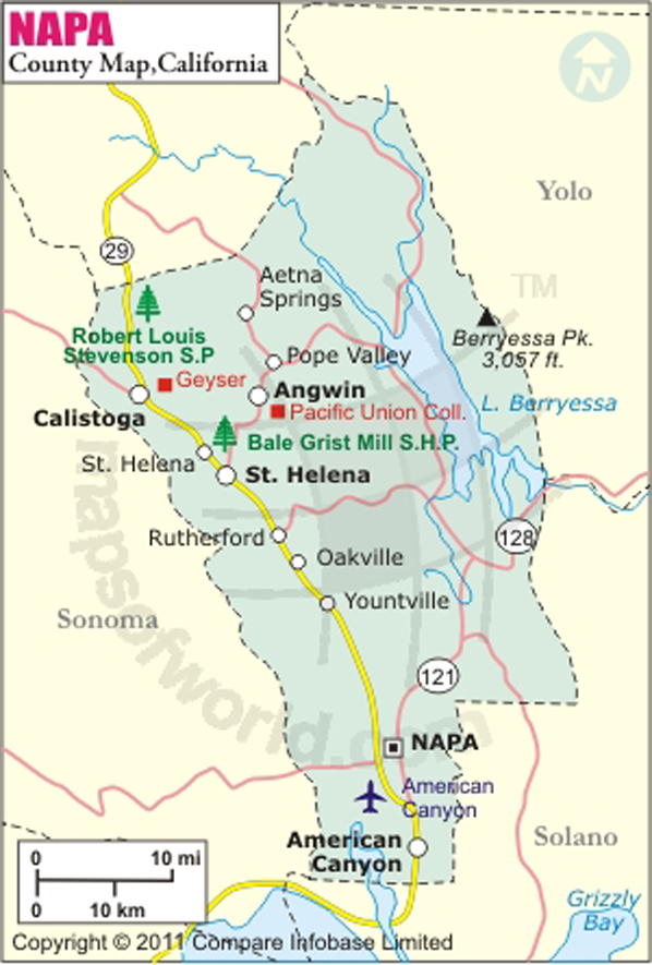
Napa County Map
Description:Map of Napa county showing the major towns, highways and much more. Disclaimer
×

Disclaimer  :  All efforts have been made to make this image accurate. However MapSherpa, Inc, its directors and employees do not own any responsibility for the correctness or authenticity of the same.


Napa County in California


With a total area of 789 square miles, Napa Valley lies north of San Pablo Bay in Northern California. Founded in 1850 with the statehood of California, it is one of four North Bay counties in the state. Due to Mediterranean summers, the county is a popular region for wine-making. Napa is the county seat and most populous city of the county. American Canyon is the second largest city in Napa County.

One sip of Cabernet Sauvignon is enough to tempt anyone to travel to Napa Valley vineyards that are widely considered as the most productive American Viticultural Areas in California. Castello di Amorosa, Bale Grist Mill State Historic Park, Lake Berryessa, Robert Louis Stevenson State Park, and Mount Saint Helena are prominent points of interest in the county.


California-based airline Surf Air provides regular flights to and from Napa County Airport (APC). International airports in Oakland and Sacramento are within two-hour drive. State Route 12 and SR 29 are major intercity routes in Napa County. The Napa Valley Wine Train operated by NVRR runs between Napa and St. Helena via region's vineyards and wineries.

MOW.DT.01.04.16

Inside the page

Facts about Napa County

County NameNapa County
FoundedFeb 18, 1850
Area789 sq mi (2,040 km2)
Land Area748 sq mi (1,940 km2)
Water Area40 sq mi (100 km2)
Population138,088 (2011 est.)
County SeatNapa
Time zonePacific Standard Time (UTC-8) Summer (DST) Pacific Daylight Time (UTC-7)

Cities in Napa County


CityCountyPopulation
  • American Canyon city
  • Napa19,454
  • Angwin
  • Napa3,051
  • Calistoga city
  • Napa5,155
  • Deer Park
  • Napa1,267
  • Moskowite Corner
  • Napa211
  • Napa city
  • Napa76,915
  • Oakville
  • Napa71
  • Rutherford
  • Napa164
  • Silverado Resort
  • Napa1,095
  • St. Helena city
  • Napa5,814
  • Yountville city
  • Napa2,933


    Airports in Napa County


    Airport Name
    Angwin Parrett Field
    Lake Berryessa Seaplane Base
    Mysterious Valley Airport
    Napa County Airport
    Pope Valley Airport
    Queen of the Valley Hospital Heliport
    River Meadow Farm Heliport
    St. Helena Fire Department Heliport

    Mountain Peaks in Napa County


    Mountain Peak/HillElevation [Meter]
    Anderson Mountain552
    Atlas Peak814
    Bald Hill509
    Bald Mountain688
    Baldy Mountain626
    Barton Hill316
    Browns Hill825
    Buck Mountain619
    Bull Hill210
    Castle Peak392
    Coyote Peak345
    Devils Head Peak269
    Elkhorn Peak366
    Ephlin Hill291
    Flat Top832
    Glass Mountain184
    Grassy Hill736
    Greeg Mountain554
    Haystack474
    High Point824
    Home Hill22
    Howell Mountain568
    Inspiration Point662
    Iron Mountain694
    Jackson Peak552
    Lemon Hill318
    Little Sugarloaf Peak491
    Lookout Point665
    Milliken Peak220
    Mount George572
    Mount Saint John713
    Mount Vaca857
    Mount Veeder817
    Oat Hill80
    Oat Hill635
    Okell Hill342
    Old Baldy836
    Potato Hill771
    Red Hill650
    Red Mountain417
    Scribner Mountain580
    Sentinel Hill576
    Signal Hill726
    Snell Peak548
    Sugarloaf499
    Sugarloaf Mountain906
    Sugarloaf Peak568
    Table Mountain857
    Table Rock722
    The Beehive833
    Three Peaks872
    Turner Mountain545
    Twin Peaks833
    Veterans Peak356
    Windy Point865


    Golf Courses in Napa County


    Name of Golf CourseLatitudeLongitude
    Aetna Springs Golf Course-Pope Valley38.654218-122.481737
    Chardonnay Golf Club-American Canyon38.21624-122.235209
    Eagle Vines Golf Club-American Canyon38.33428-122.297518
    Meadowood Napa ValleyResort-Saint Helena38.519041-122.46147
    Mount Saint Helena Golf Course-Calistoga38.586127-122.584198
    Napa Golf Course At Kennedy Park-Napa38.268967-122.280173
    Napa Valley Country Club-Napa38.323582-122.246174
    Silverado Country Club & Resort-Napa38.348537-122.267201
    Vineyard Knolls Golf Club-Napa38.262178-122.341968
    Vintner's Golf Club-Yountville38.396198-122.358669


    Map of Cities in California

    Long Beach city MapOakland city MapAnaheim city Map
    Santa Ana city MapRiverside city MapStockton city Map
    Chula Vista city MapFremont city MapIrvine city Map
    San Bernardino city MapModesto city MapOxnard city Map
    Los Angeles city Map San Francisco city Map Sacramento city Map
    San Jose city Map Bakersfield city Map Fullerton city Map


    Last Updated Date: September 20th, 2021