logo


Mono County Map

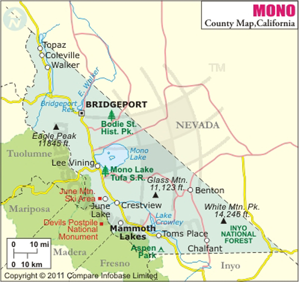
Below is County Map of Mono in California showing the boundaries, roads, highways, towns and much more.

Map of Mono County, California
Mono County Map
Description:Map of Mono county showing the major towns, highways and much more. Disclaimer
×

Disclaimer  :  All efforts have been made to make this image accurate. However MapSherpa, Inc, its directors and employees do not own any responsibility for the correctness or authenticity of the same.


Inside the page

Facts about Mono County

County NameMono County
Founded1861
Area3,132 sq mi (8,110 km2)
Land Area3,049 sq mi (7,900 km2)
Water Area83 sq mi (210 km2)
Population14,202 (2010)
Largest cityMammoth Lakes (population and area)
County SeatBridgeport
Time zonePacific Standard Time (UTC-8) Summer (DST) Pacific Daylight Time (UTC-7)

Founded in 1861, Mono County is located east of the Sierra Nevada in central California. It is the fifth least populous county in California. Bridgeport is the county seat and the county's only incorporated town is Mammoth Lakes. About 3,132 square miles of the county's area stretches between Yosemite National Park and the state border with Nevada.

Bodie, the famous gold rush ghost town 12 miles southeast of Bridgeport, is now preserved as a California State Historic Park emphasizing its eerie nature. Mono Lake, a shallow alkaline lake, is a vital habitat for migratory and nesting birds. The Mammoth Mountain Ski Area in the Inyo National Forest is a popular ski destination during the winter months.

Bridgeport lies at the juncture of U.S. Route 395 and State Route 182. Eastern Sierra Transit Authority operates intercity bus service in the region.

MOW.DT.01.17.17


Cities and Towns in Mono County


CityCountyPopulation
Aspen SpringsMono65
BentonMono280
BridgeportMono575
ChalfantMono651
ColevilleMono495
Crowley LakeMono875
June LakeMono629
Lee ViningMono222
Mammoth Lakes townMono8,234
McGee CreekMono41
Mono CityMono172
ParadiseMono153
Sunny SlopesMono182
Swall MeadowsMono220
TopazMono50
WalkerMono721


Mountain Peaks in Mono County


Mountain Peak/HillElevation [Meter]
Aeolian Buttes2,183
Anderson Peak2,102
Antelope Mountain2,322
Bald Mountain2,769
Black Mountain2,698
Black Mountain3,584
Black Point2,111
Blacktop Peak3,881
Blanco Mountain3,420
Bloody Mountain3,825
Bodie Mountain3,101
Brawley Peaks2,806
Bucks Peak3,309
Buscones Peak2,099
Bush Mountain2,696
Campito Mountain3,522
Carson Peak3,312
Casa Diablo Mountain2,404
Cedar Hill2,570
Center Mountain3,410
Cirque Mountain3,217
Copper Mountain2,881
County Line Hill3,426
Cowtrack Mountain2,698
Crater Crest3,478
Crater Mountain2,786
Crown Point3,444
Crystal Crag3,141
Deer Mountain2,666
Diana Peak2,161
Dome Hill2,467
Dome Hill2,445
Dome Two2,539
Donohue Peak3,651
Dry Creek Knoll2,695
Dunderberg Peak3,774
Eagle Peak3,603
Earthquake Dome2,850
Ehrnbeck Peak3,428
Epidote Peak3,338
Flatiron Butte3,453
Gabbro Peak3,340
Gaylor Peak3,351
Gilbert Peak2,611
Gilcrest Peak3,528
Glass Mountain3,395
Granite Mountain2,720
Grizzly Peak3,114
Grouse Mountain3,271
Hanna Mountain3,491
Hawksbeak Peak3,385
Headley Peak3,858
Hunewill Peak3,562
Indian Peak3,443
Indiana Summit2,496
Iron Mountain2,895
June Mountain3,084
Juniper Mountain2,394
Kettle Peak3,341
Koip Peak3,954
Kuna Peak3,958
Laurel Mountain3,604
Lee Vining Peak3,565
Lookout Mountain2,543
Lost Cannon Peak3,355
Mammoth Knolls2,675
Mammoth Mountain3,355
Masonic Mountain2,809
McGee Mountain3,305
Middle Sister3,306
Middle Sister3,287
Minaret Summit2,824
Modoc Peak2,100
Mono Dome3,235
Mono Jim Peak3,252
Montgomery Peak4,098
Mount Aggie3,520
Mount Andrea Lawrence3,727
Mount Baldwin3,838
Mount Barcroft3,979
Mount Biedeman2,736
Mount Dubois4,126
Mount Emma3,211
Mount Hogue3,884
Mount Huntington3,766
Mount Jackson2,858
Mount Lewis3,765
Mount Morgan3,962
Mount Morrison3,731
Mount Olsen3,368
Mount Patterson3,552
Mount Scowden3,385
Mount Stanford3,908
Mount Warren3,634
Mount Wood3,855
New York Hill2,629
North Peak3,728
Obsidian Dome2,608
Page Peaks3,316
Panorama Dome2,724
Panum Crater2,145
Parker Peak3,919
Pearce Peak2,055
Pinyon Mountain2,669
Piute Mountain3,827
Potato Peak3,113
Red Mountain3,495
Red Mountain2,410
Red Peak3,082
Reversed Peak2,882
Rickey Peak3,063
Robinson Peak3,274
Round Mountain2,326
Round Mountain1,742
Sage Hen Peak2,871
Sagehen Peak2,777
Sheep Mountain3,801
Silver Hill2,645
South Sister3,442
Station Peak3,110
Sugarloaf2,638
The Jumpoff4,057
Tioga Peak3,503
Trafton Mountain2,381
Two Teats3,452
Victoria Peak3,561
Volcanic Butte2,622
Walker Mountain3,515
Wells Peak3,294
Wheeler Peak3,545
White Mountain3,674
White Mountain3,470
White Mountain Peak4,338
White Wing Mountain3,050
Wild Horse Mountain2,639
Williams Butte2,526
Wilson Butte2,562


Airports in Mono County


Airport Name
Bryant Field
Lee Vining Airport
Mammoth Yosemite Airport
Mcmwtc Heliport
Mono County Medical Heliport

Golf Courses in Mono County


Name of Golf CourseLatitudeLongitude
Sierra Star Golf Course-Mammoth Lakes37.639139-118.982291
Snowcreek Resort Golf Course-Mammoth Lakes37.63124-118.972552

National Parks in Mono County


Name of ParkLatitudeLongitude 
Yosemite NP37.848203-119.556299

County Maps of California

Alameda County MapMarin County MapSan Luis Obispo County Map
Alpine County MapMariposa County MapSan Mateo County Map
Amador County MapMendocino County MapSanta Barbara County Map
Butte County MapMerced County MapSanta Clara County Map
Calaveras County MapModoc County MapSanta Cruz County Map
Colusa County MapMono County MapShasta County Map
Contra Costa County MapMonterey County MapSierra County Map
Del Norte County MapNapa County MapSiskiyou County Map
El Doredo County MapNevada County MapSolano County Map
Fresno County MapOrange County MapSonoma County Map
Glenn County MapPlacer County MapStanislaus County Map
Humboldt County MapPlumas County MapSutter County Map
Imperial County MapRiverside County MapTehama County Map
Inyo County MapSacramento County MapTrinity County Map
Kern County MapSan Benito County MapTulare County Map
Kings County MapSan Bernardino County MapTuolumne County Map
Lake County MapSan Diego County MapVentura County Map
Lassen County MapSan Francisco County MapYolo County Map
Los Angeles County MapSan Joaquin County MapYuba County Map
Madera County Map 


Map of Cities in California

Long Beach city MapOakland city MapAnaheim city Map
Santa Ana city MapRiverside city MapStockton city Map
Chula Vista city MapFremont city MapIrvine city Map
San Bernardino city MapModesto city MapOxnard city Map
Los Angeles city Map San Francisco city Map Sacramento city Map
San Jose city Map Bakersfield city Map Fullerton city Map


Last Updated Date: September 20th, 2021